Rated the strongest typhoon since Haiyan, which killed 6,000 people in the Philippines last November, Super Typhoon Vongfong in the extreme western tropical Pacific now has peak winds of 165 mph and ocean swells as high as 50 ft as it moves northward toward Okinawa, Japan.
I put together this NASA MODIS image montage, only a few hours old, which shows the intricate swirling cloud structure within the eye of the typhoon early Thursday afternoon (click for full-size):
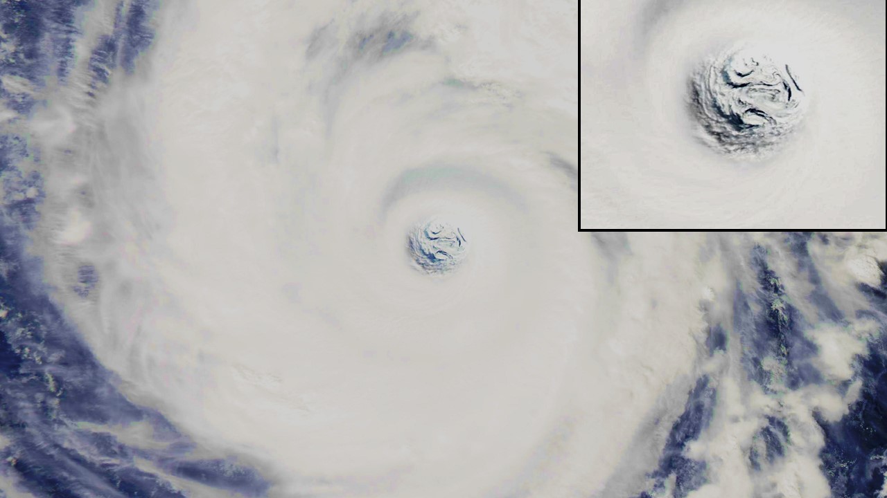
Here are some other great views of Typhoon Vongfong at mashable.com.
The low clouds in the eye seem to show two embedded counter-cyclone rotations. Any idea how big it is across?
they say it’s been fluctuating between 20 and 30 miles in diameter.
embedded circulations have also been seen in the “eye” of very strong extratropical cyclones over the ocean. This is pretty common in systems with strong vorticity, and seems to occur on all scales…such as tornadoes forming within a much larger mesocyclone, and even suction vorticies forming within the tornado.
I’ve seen pictures of tornados with feeders close around the outside. But I guess this is big enough to do whatever it wants. : )
Dah. I didn’t read the text at mashable:
“The eye of Vongfong has fluctuated between about 19 and 30 miles wide. The storm has exhibited spirals of low clouds in the middle of the eye, where the air is sinking and warming, and the winds are comparatively calm.”
They must be fog clouds very close to the surface since I don’t think descending air normally forms clouds.
The “eye” looks like somebody, an old man, I used to know.
And thank you very much for the link to “The 8 Best Views of Category 5 Super Typhoon Vongfong” Dr. Spencer. Great stuff (as long as we are not in it’s path.
Dear Dr. Spencer,
I heard that hurricanes are depressed in a typical El Nino year. Is this true? If so do we know the reason?
Submitted here by mistake, pleases ignore
Thanks, Dr. Spencer.
I found this image: http://www.usno.navy.mil/NOOC/nmfc-ph/RSS/jtwc/ab/abpwsair.jpg
The Western/South Pacific Ocean image came from the Joint Typhoon Warning Center (JTWC) (U.S. Naval Oceanography Portal), at http://www.usno.navy.mil/JTWC/
There is also: http://www.usno.navy.mil/NOOC/nmfc-ph/RSS/jtwc/ab/abiosair.jpg (Indian Ocean).
Looks like the world’s largest heat pipe pumping heat from the water to the upper atmosphere.
Exactly, Dan.
I was wondering that. Guessing from the 20mi dia and the mashable animation, it looks like it goes all the way up to the tropopause (7.5mi). Must be a heck of an organized vertical circulation of moist (high heat content) air.
Yes, Jim, see The Thermostat Hypothesis (Willis Eschenbach, 2009), at http://www.oarval.org/ThermostatBW.htm
That paper sounds like another case for negative feedback (contra-Mann).