Archive for April, 2018

New Lewis & Curry Study Concludes Climate Sensitivity is Low

Tuesday, April 24th, 2018

Global warming “problem” cut by 50%

As readers here are aware, I don’t usually critique published climate papers unless they are especially important to the climate debate. Too many papers are either not that important, or not that convincing to me.

The holy grail of the climate debate is equilibrium climate sensitivity (ECS): just how much warming (and thus associated climate change) will occur in response to an eventual doubling of the CO2 concentration in the atmosphere?

Yesterday’s early online release of a new paper by Nicholas Lewis and Judith Curry (“The impact of recent forcing and ocean heat uptake data on estimates of climate sensitivity“, Journal of Climate) represents one of those seminal papers.

It is an extension of a previously published paper by Lewis & Curry, adding more data, and addressing criticisms of their earlier work. Its methodology isn’t entirely original, since previous (but somewhat preliminary) work along the same lines (Otto et al., 2013) has resulted in observational estimates of relatively low climate sensitivity compared to the IPCC climate models.

But what is notable to me is (1) the comprehensive extent to which methodological and data uncertainties have been addressed, and (2) the fact it was published in the relatively mainstream and consensus-defending Journal of Climate.

Basically, the paper concludes that the amount of surface and deep-ocean warming that has occurred since the mid- to late-1800s is consistent with low equilibrium climate sensitivity (ECS) to an assumed doubling of atmospheric CO2. They get a median estimate of 1.66 deg. C (1.50 deg. C without uncertain infilled Arctic data), which is only about half of the average of the IPCC climate models. It is just within the oft-quoted range of 1.5 to 4.5 deg. C that the IPCC has high confidence ECS should occupy.

The last I knew, Lewis’s belief is that the biggest uncertainty in the ECS calculation is how accurate the assumed forcings are that must be used to make the ECS computation (over the last ~130 years, the climate system has stored a certain amount of extra energy in the ocean, and shed a certain amount of energy to space from increased surface temperatures, in response to assumed changes in radiative forcing…. a big uncertainty in which is assumed anthropogenic aerosol-related cooling).

I’d like to additionally emphasize overlooked (and possibly unquantifiable) uncertainties: (1) the assumption in studies like this that the climate system was in energy balance in the late 1800s in terms of deep ocean temperatures; and (2) that we know the change in radiative forcing that has occurred since the late 1800s, which would mean we would have to know the extent to which the system was in energy balance back then.

We have no good reason to assume the climate system is ever in energy balance, although it is constantly readjusting to seek that balance. For example, the historical temperature (and proxy) record suggests the climate system was still emerging from the Little Ice Age in the late 1800s. The oceans are a nonlinear dynamical system, capable of their own unforced chaotic changes on century to millennial time scales, that can in turn alter atmospheric circulation patterns, thus clouds, thus the global energy balance. For some reason, modelers sweep this possibility under the rug (partly because they don’t know how to model unknowns).

But just because we don’t know the extent to which this has occurred in the past doesn’t mean we can go ahead and assume it never occurs.

Or at least if modelers assume it doesn’t occur, they should state that up front.

If indeed some of the warming since the late 1800s was natural, the ECS would be even lower.

Now the question is: At what point will the IPCC (or, maybe I should say climate modelers) start recognizing that their models are probably too sensitive? Remember, the sensitivity of their models is NOT the result of basic physics, as some folks claim… it’s the result of very uncertain parameterizations (e.g. clouds) and assumptions (e.g. precipitation efficiency effects on the atmospheric water vapor profile and thus feedback). The models are adjusted to produce warming estimates that “look about right” to the modelers. Yes, *some* amount of warming from increasing CO2 is reasonable from basic physics. But just how much warming is open to manipulation within the uncertain portions of the models.

Maybe it’s time for the modelers to change their opinion of how much warming “looks about right”.

The 100th Meridian Agricultural Scare: Another Example of Media Hype Exceeding Reality

Wednesday, April 18th, 2018

A new paper published in the AMS Earth Interactions entitled, Whither the 100th Meridian? The Once and Future Physical and Human Geography of America’s Arid-Humid Divide, Part II: The Meridian Moves East, discusses the climate model-expected drying of the western U.S. and how this will affect the agricultural central- and east- U.S. as the climatological boundary roughly represented by the 100th Meridian moves eastward.

This paper has become a good example of media hype overwhelming actual substance. For example, take this headline from Doyle Rice at USAToday on April 13,

“A major climate boundary in the central U.S. has shifted 140 miles due to global warming”

So, what’s wrong with the headline? Nowhere in the original scientific study can I find any observational evidence of such a shift.

The fact is, the study is a modeling study — not observational. They tell us what might happen in the coming decades, given certain (and numerous) assumptions.

Since I’ve been consulting for U.S. grain interests for the last seven or eight years, I have some interest in this subject. Generally speaking, climate change isn’t on the Midwest farmers’ radar because, so far, there has been no sign of it in agricultural yields. Yields (production per acre) of all grains, even globally, have been on an upward trend for decades. This is fueled mainly by improved seeds, farming practices, and possibly by the direct benefits of more atmospheric CO2 on plants. If there has been any negative effect of modestly increasing temperatures, it has been buried by other, positive, effects.

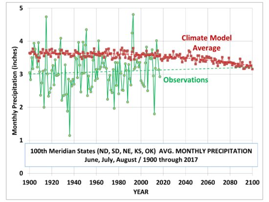
And so, the study begs the question: how has growing season precipitation changed in this 100th meridian zone? Using NOAA’s own official statewide average precipitation statistics, this is how the rainfall observations for the primary agricultural states in the zone (North and South Dakota, Nebraska, Kansas, and Oklahoma) have fared every year between 1900 and 2017:

Jun, July, August average monthly precipitation as observed over 5 U.S. states encompassing the 100th Meridian, and as predicted by a CMIP5 (RCP8.5 forcing scenario) multi-model mean from 35N to 50N, and 95W to 105 W (observational data from https://www.ncdc.noaa.gov/cag/statewide/time-series; model data from https://climexp.knmi.nl/selectfield_cmip5.cgi?id=someone@somewhere)

What we see is that there has been, so far, no evidence of decreasing precipitation amounts exactly where the authors claim it will occur (and according to press reports, has already occurred).

To the authors’ credit, in their final “Discussion and Conclusions” section of the research paper they admit:

“First, we have shown that state-of-the-art models simulate the aridity gradient across North America poorly.”

“Second, while current Earth system models predict widespread declines in soil moisture and increases in continental aridity, they also simulate increases in net primary productivity. This is because, within the models, the beneficial effects on photosynthesis and water-use efficiency of increased CO2 overwhelm the effects of increased temperature and vapor pressure deficit.” (emphasis added)

The positive effects of more CO2 on global agricultural yields have been tallied, as I have previously discussed here.

Yet, the popular press emphasizes the alarmist nature of the article, even going so far as to make as the central claim something that, as far as I can tell, isn’t even in the paper (!)

Midwest’s April chill most unusual on Earth

Monday, April 16th, 2018

If you thought the cold April weather in the U.S. was exceptional, you are correct.

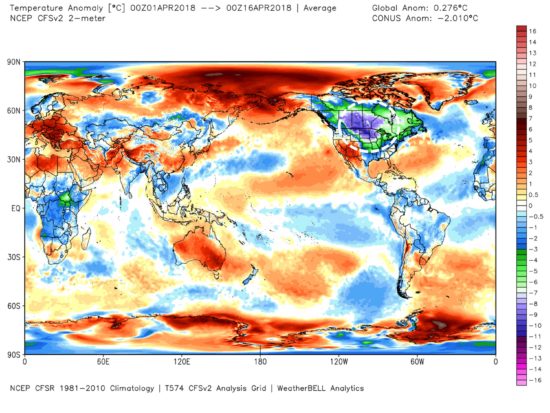
In terms of temperature departures from average so far this April, the U.S. Midwest, Northern Plains, and much of Canada have been the coldest on Earth (graphic courtesy of Weatherbell.com):

Surface temperature departures from normal for April 1 through April 15, 2018.

The areas of green have averaged at least 6 deg. F below normal, the areas in purple have been at least 13 deg. F below normal, and spots in North Dakota and Montana have averaged close to 20 deg F below normal over the last 2 weeks. In contrast, the global average temperature has been running 0.5 deg. F above the 1981-2010 average.

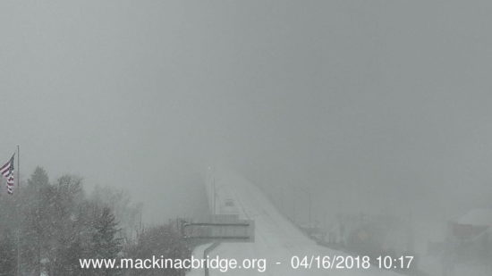
Snow flurries were experienced as far south as Russellville, Alabama yesterday, and flurries are still falling in portions of Tennessee. Green Bay, WI received 2 feet of new snow from the slow-moving snow and ice storm still affecting the Great Lakes region. Northern Michigan is still experiencing heavy snow, with whiteout conditions this morning at the Mackinac Bridge, which connects Michigan’s Upper and Lower Peninsulas:


Stormy April to give snow job to Midwest

Thursday, April 12th, 2018

Friday the 13th is not shaping up to be very lucky for some people, weather-wise.

A strong springtime (or late winter?) storm currently moving across the northern and central Rockies will move east over the next several days with a wide variety of severe weather, including blizzard conditions to the north and severe thunderstorms to the south.

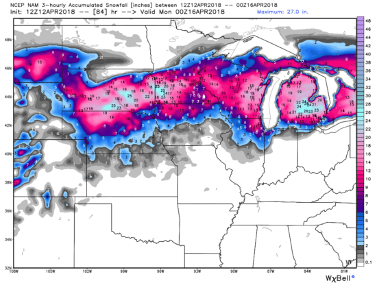
By Sunday evening, a foot or more of snow accumulation is expected over portions of Nebraska, South Dakota, Wisconsin, Michigan, and Minnesota (including Minneapolis-St. Paul). Up to 2 feet is possible in some areas. Chicago and Detroit could see as much as 6-12 inches.

The latest forecast from NOAA’s NAM model is roughly consistent with previous U.S. and European forecast model runs, but the exact path of the heaviest snowfall has been somewhat uncertain, especially for Wisconsin and Michigan (all graphics courtesy of Weatherbell.com):

Forecast total snowfall by Sunday evening April 15, 2018, from NOAA’s NAM forecast model run on Thursday morning, April 12.

By Tuesday, portions of 30 to 35 states will see some snowfall, with flurries extending as far south as eastern Tennessee and central Missouri. It will snow almost continuously for 3-4 days (Friday through Monday) over portions of northern Wisconsin and northern Michigan. I-90 east of Rapid City will probably have to be closed by Friday night.

The unusually large low pressure area extending from the Canadian border to the Gulf coast will produce an array of weird and wild weather.

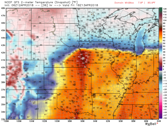
For example, by tomorrow (Friday) afternoon, eastern Nebraska will be in the mid-80s, while heavy snow and blizzard conditions will exist over the western part of the state. Only a few tens of miles will separate summer weather from winter weather across the Midwest and the southern Great Lakes:

Surface temperature forecast for early afternoon Friday April 13 from the GFS model run at midnight April 12.

Severe thunderstorms will move across the Southern Plains on Friday and the southeast U.S. on Saturday as the accompanying cold front moves eastward.

Yes, sometimes it snows in April.

And Friday the 13th might not turn out to be very lucky for you if you plan on traveling in the northern Midwest.

DC Cherry Blossom Peak to be met with Peak Snow?

Wednesday, April 4th, 2018

Tidal Basin cherry blossoms on March 29, 2016 (left); and then on March 14, 2017 after an early blossom then snow (right). Photo by Kevin Ambrose, Washington Post.

After continuing delays due to cold weather, the National Park Service’s daily update for the DC Tidal Basin cherry blosson predicts that the peak blossom time will finally be this weekend.

But you might want to get out the snow shovel if you want to go see this annual event.

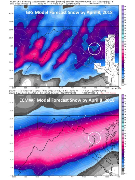
The latest weather forecast models are predicting anywhere from 6 to 18 inches of snow by Sunday morning, beginning late Friday night, April 6 (all forecast graphics courtesy of Weatherbell.com):

Weather model forecasts of total snowfall by Sunday morning, April 8, 2018. The DC metro area is in the circle. All forecast graphics courtesy of Weatherbell.com.

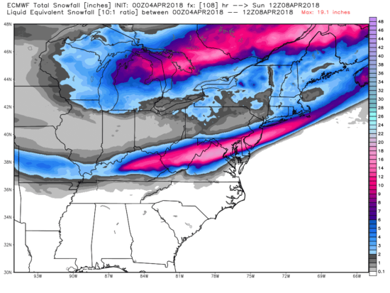
The swath of snow forecast to affect the DC area is unusually far south for April, as seen in the ECMWF forecast ending Sunday morning for the eastern U.S.:

Total forecast snowfall from the ECMWF model as of Sunday morning, April 8, 2018 for the eastern U.S.

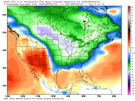
And if you think this is just a temporary cold shot that will immediately give way to warmer temperatures, here’s the GFS model forecast of temperature departures from normal averaged over the next 10 days, which shows a widespread area averaging 10-12 deg F below normal:

GFS model forecast of 10-day average temperature departures from normal for the period April 4 through April 13.

That’s the average over the next 10 days. On most individual days in the period, some areas will be 20-30 deg. F below normal.

UAH Global Temperature Update for March, 2018: +0.24 deg. C

Monday, April 2nd, 2018

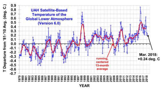
The Version 6.0 global average lower tropospheric temperature (LT) anomaly for March, 2018 was +0.24 deg. C, up a little from the February value of +0.20 deg. C:

Global area-averaged lower tropospheric temperature anomalies (departures from 30-year calendar monthly means, 1981-2010). The 13-month centered average is meant to give an indication of the lower frequency variations in the data; the choice of 13 months is somewhat arbitrary… an odd number of months allows centered plotting on months with no time lag between the two plotted time series. The inclusion of two of the same calendar months on the ends of the 13 month averaging period causes no issues with interpretation because the seasonal temperature cycle has been removed, and so has the distinction between calendar months.

Some regional LT departures from the 30-year (1981-2010) average for the last 15 months are:

YEAR MO GLOBE NHEM. SHEM. TROPIC USA48 ARCTIC AUST
2017 01 +0.33 +0.31 +0.34 +0.10 +0.27 +0.95 +1.22
2017 02 +0.38 +0.57 +0.19 +0.08 +2.15 +1.33 +0.21
2017 03 +0.23 +0.36 +0.09 +0.06 +1.21 +1.24 +0.98
2017 04 +0.27 +0.28 +0.26 +0.21 +0.89 +0.22 +0.40
2017 05 +0.44 +0.39 +0.49 +0.41 +0.10 +0.21 +0.06
2017 06 +0.21 +0.33 +0.10 +0.39 +0.50 +0.10 +0.34
2017 07 +0.29 +0.30 +0.27 +0.51 +0.60 -0.27 +1.03
2017 08 +0.41 +0.40 +0.42 +0.46 -0.55 +0.49 +0.77
2017 09 +0.54 +0.51 +0.57 +0.54 +0.29 +1.06 +0.60
2017 10 +0.63 +0.66 +0.59 +0.47 +1.20 +0.83 +0.86
2017 11 +0.36 +0.33 +0.38 +0.26 +1.35 +0.68 -0.12
2017 12 +0.41 +0.50 +0.33 +0.26 +0.44 +1.36 +0.36
2018 01 +0.26 +0.46 +0.06 -0.12 +0.58 +1.36 +0.42
2018 02 +0.20 +0.24 +0.15 +0.03 +0.91 +1.19 +0.18
2018 03 +0.24 +0.39 +0.10 +0.06 -0.33 -0.33 +0.59

The linear temperature trend of the global average lower tropospheric temperature anomalies from January 1979 through March 2018 remains at +0.13 C/decade.

The UAH LT global anomaly image for March, 2018 should be available in the next few days here.

The new Version 6 files should also be updated in the coming days, and are located here:

Lower Troposphere: http://vortex.nsstc.uah.edu/data/msu/v6.0/tlt/uahncdc_lt_6.0.txt
Mid-Troposphere: http://vortex.nsstc.uah.edu/data/msu/v6.0/tmt/uahncdc_mt_6.0.txt
Tropopause: http://vortex.nsstc.uah.edu/data/msu/v6.0/ttp/uahncdc_tp_6.0.txt
Lower Stratosphere: http://vortex.nsstc.uah.edu/data/msu/v6.0/tls/uahncdc_ls_6.0.txt

Return to Sender? China is Country Most Likely to See Tiangong-1 Burn Up

Sunday, April 1st, 2018

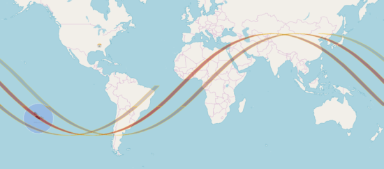
As China’s Tiangong-1 Space Station now rapidly falls to meet its fiery demise in the next several hours, the Aerospace Corporation’s most recent estimate of the potential paths of reentry show that China has the greatest statistical chance of any country of seeing the spectacle, with the longest potential reentry orbit sections:

Aerospace Corp estimate of the most likely orbits which the Tiangong-1 satellite will reenter the atmosphere from. Graphic courtesy of satflare.com.

Of course, the Pacific Ocean and the S. Atlantic have a bigger chance, but it would be fitting if China got a few pieces of their first Space Station returned to them.

The latest estimated reentry time (see updates here) is 8:18 EDT today (April 1), +/-2 hours.