I’ve been getting quite a few e-mails about the data on the UAH/NASA Discover website, which gives daily global average deep-layer average temperatures from the AMSU instruments on the NOAA-15 satellite and NASA’s Aqua satellite (as well as sea surface temperatures from the AMSR-E instrument on Aqua).
I have been advising users that, of all the AMSU channels listed there, to trust only the “ch. 5” (mid-tropospheric) temperatures, since all of the other channels at the Discover website are from the NOAA-15 satellite, which has diurnal drift issues. Hopefully later this week we will transition those other channels from NOAA-15 AMSU to Aqua AMSU, so there will be no long-term drift issues from changes in the satellite observation time. The downside will be that all of the data will only be available since Aqua data started flowing, in mid-2002. (Again, the sea surface temperature variations are very accurate, and come from a completely different instrument using different methods).
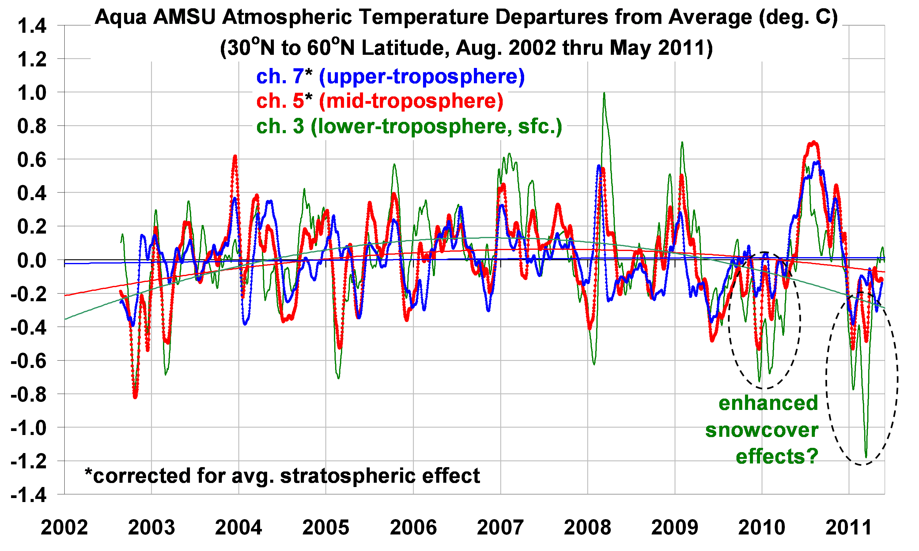
Since there is considerable interest in the subject of “global cooling”, I thought I would give a preview of some of the Aqua AMSU data for the Northern Hemisphere mid-latitudes, which are shown in the following plot…these are daily running 31-day averages, area averaged over the 30N to 60N latitude band (click on the image for the HUGE version):
There are several observations that can be made from the above plot:
1) there has been no significant long-term LINEAR trend in any of the channels;
2) the mid-troposphere and low-troposphere channels show warming early in the record, then cooling late in the record, as indicated by the 2nd order polynomial curved fits shown;
3) Late summer 2010 was, indeed, quite warm in the NH mid-latitudes.
Note that, in general, ch. 3 should not be relied upon to infer temperature changes, due to it’s sensitivity to a variety of non-temperature effects from the surface. This is especially true over the ocean, where low clouds produce an anomalous warm signature against the radiometrically cold ocean background (I will show an example later).
But since we are looking at a primarily land-covered latitude band, we only need to be concerned with a different non-temperature effect: snowcover. The particularly strong late-period cooling seen in the channel 3 data is likely the result of volume scattering by enhanced snow cover in 2010 and 2011. This is a known issue with passive microwave measurements, and is the basis for snow cover, snow depth, and snow water equivalent retrievals which are used by NASA and NOAA, primarily from the AMSR-E instrument.
Note that the polynomial fits I have applied to the data are only meant to show what happened during this period…I am not suggesting they have any forecast value for the future. I will let others discuss that. Nevertheless, I think the data are useful for getting some idea of what has happened over the last decade in the region where most people live. I think the bottom line from a global warming perspective is that there has been no obvious sign of warming in the last 9 years.
The Arctic Since 2002
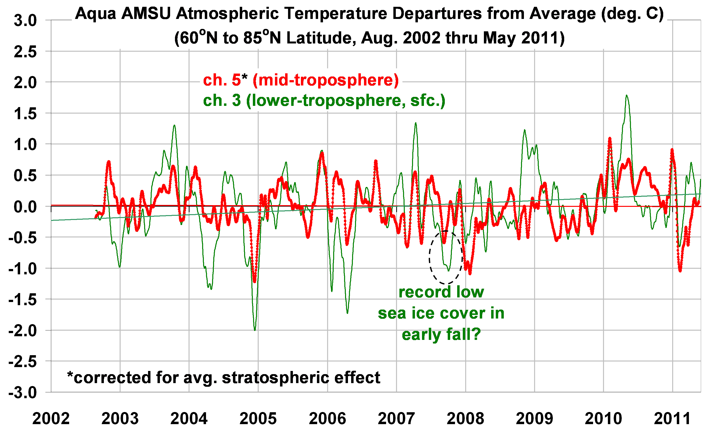
Here are the results for the Arctic region, 60N to 85N, but without channel 7 which has a large stratospheric contamination in Arctic air masses:
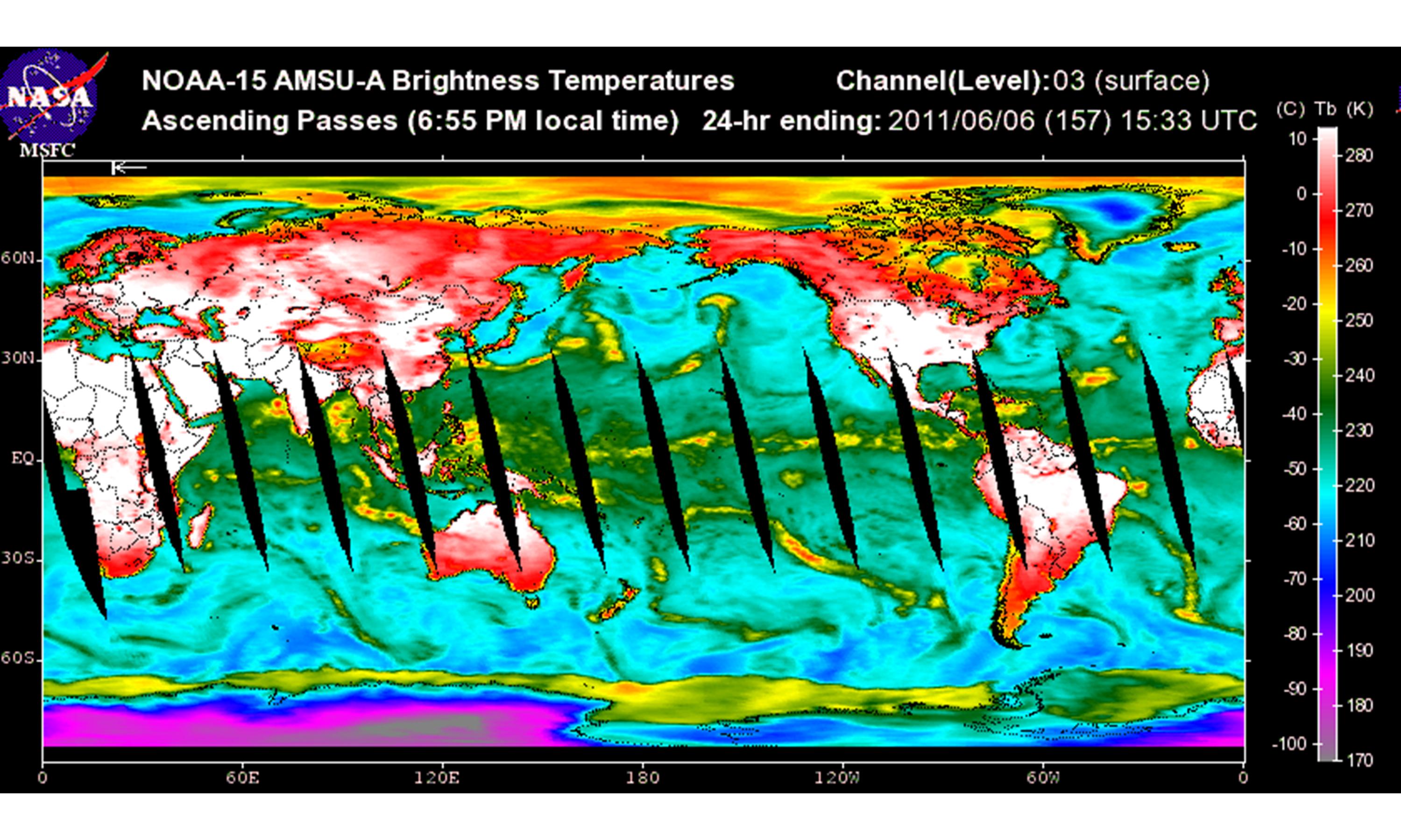
The tropospheric temperatures show no trend, while the channel 3 data shows an upward trend. In the Arctic, the channel 3 data now also become sensitive to sea ice, which causes a warm signature compared to the cold ocean background. If you don’t believe ice can cause a “warm” signal, check out today’s NOAA-15 channel 3 imagery, which shows warm signatures in the Arctic ocean and in the sea ice area surrounding Antarctica:
This is because microwave radiometers measure brightness temperature, which is a product of the temperature of an object and its microwave emissivity (1 minus its reflectivity).
To make things even more difficult in the interpretation of ch. 3, more snow cover on sea ice will cause an anomalously cold signal, rather than warm signal, just as it does over land — unless the snow is melting, in which case it switches to an anomalously warm signal. The point is that it is difficult to interpret what the upward trend in the Arctic channel 3 data is due to. Stratifying the data by season would probably give some insight.
For now, though, I think the tropospheric (AMSU ch. 5) data are pretty clear: there are no signs of warming in the last nine years in those regions where the strongest warming in the last 30 to 40 years has occurred, that is, in the Northern Hemisphere mid- and high-latitudes. And, there might even be signs of recent cooling over the last few years in the mid-latitudes, but whether this will persist is anyone’s guess.

 Home/Blog


