Here’s a satellite view looking south across the Caspian Sea today, October 11, 2014, from the MODIS instrument on NASA’s Terra satellite (click for full size):

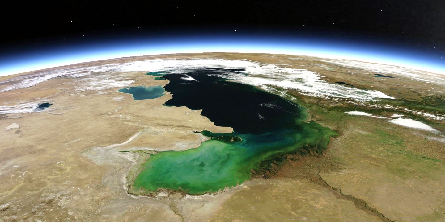
The Caspian Sea on October 11, 2014, as seen by the MODIS instrument on NASA’s Terra satellite, remapped into Google Earth.
The Caspian Sea is the world largest enclosed inland water body, and is bordered by Kazakhstan, Russia, Azerbaijan, Iran, and Turkmenistan. It is one-fourth as salty as the ocean. Also seen is the Volga River.
Thanks, Dr. Spencer. Fantastic picture!
MODIS was passing north of the Caspian Sea, but not enough, it just missed Volgograd, it seems to me.
Andres, I’m showing a remapped subset of the MODIS data in Google Earth with a limited perspective.
Hello Roy,
Thank you for learning how to access the satellite images and giving them to us. They are more than beautiful.
They document the fact that the lower troposphere always contains some particles whose diameters are at least equal to the wavelength of red visible light. For the visible sunlight scattered by these particles just above the earth’s limb is a continuous white ‘layer’ all around the globe. And just above this white layer is a milky blue color which transitions into a vivid blue one, due the scattering of the sunlight by the atmospheric molecules, which in turn gradually transitions to black as the density of these atoms and molecules decreases.
And the image of the Caspian Sea and your commentary about it prompted me to first study my globe, and then to go wikipedia to quickly learn more, like about its elevation. Imagine my surprise when I discovered that its surface elevation was about negative 28 meters.
Then even more surprising was that its surface elevation was known to be not at all constant. Surprising because I have never read (heard) of what I read (Wikipedia): “Over the centuries, Caspian Sea levels have changed in synchrony with the estimated discharge of the Volga, which in turn depends on rainfall levels in its vast catchment basin. Precipitation is related to variations in the amount of North Atlantic depressions that reach the interior, and they in turn are affected by cycles of the North Atlantic Oscillation. Thus levels in the Caspian Sea related to atmospheric conditions in the North Atlantic thousands of miles to the northwest. (citation needed)
“The last short term sea-level cycle started with a sea level fall of 3 m (9.84 ft) from 1929 to 1977 followed by a rise of 3 m (9.84 ft) from 1977 until 1995. Since then smaller oscillations have taken place. (19)”
And because of studying the globe (an old one) I saw I might see the Aral Sea to the east of the Caspian. After I got myself orientated to the image, I finally saw some water to the east but it did not appear near as large as that on my globe. Again I went to wikipedia for quick information and discovered that by 2007 the Aral Sea had shrunk to a tenth of its 1960 size. Which was when the river water that fed it began to be diverted to irrigation projects. And I quote wikipeidia: “The retreat of the sea has reportedly also caused local climate change with summers becoming hotter and drier, and winters colder and longer. (7)” Now, I am not surprised with the latter because I have always speculated that if one wants to find man-made climate change, look at large irrigation projects in a formerly desert-like regions. And because it had been considered common knowledge that large bodies of water moderated the temperature (and weather) of the surrounding land, especially that downwind of the prevailing winds, the reported change was not surprising. Had been because I do not know if this is still common knowledge.
Another comment I have about this image is that if I had not looked at my globe I would have known the likely cause of the extensive clouds just to the southwest of the Caspian Sea. The Caucasus Mountain Range, whose highest peak is 18,510 ft above sea level, extends from the Black Sea to the Caspian Sea.
I draw attention to all these factors because I believe they all, plus some I have not addressed because this might be considered too long already, are factors having influence upon weather and climate.
Have a good day,
Jerry L. Krause
Great image.
“The Caspian Sea is the world largest enclosed inland water body,…”
I wonder why the Black Sea is not included in this comparison. Black Sea is about a sixth larger in surface area. Not enclosed, maybe?