Winter has gotten an early start in Russia, with much of the expansive country already covered in snow (even though it’s only mid-October) and temperatures running well below normal.
The immediate future looks worse. The GFS model forecast from last night shows temperatures over the next 7 days running 10 to 20 deg. F below normal, and a rapid buildup of the snowpack (click image for full size, based upon graphics from WeatherBell.com):

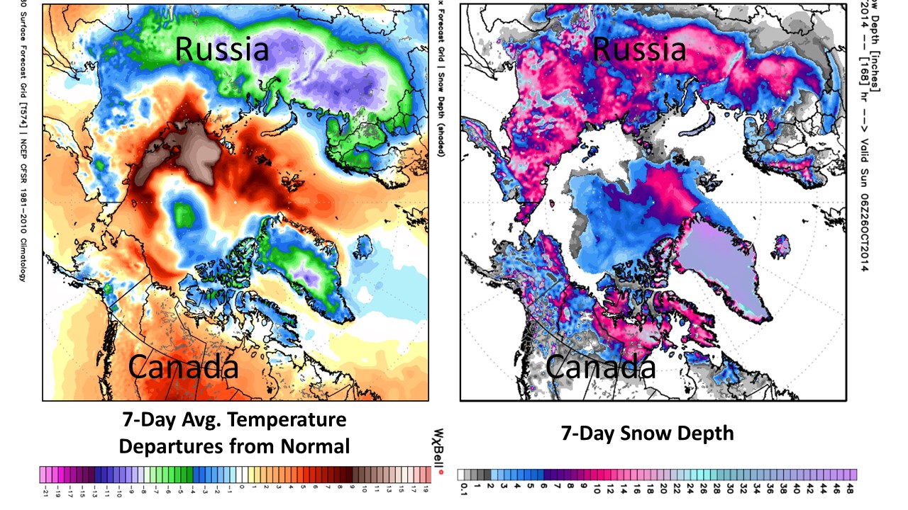
GFS 7-day forecast of average temperature departures from normal (deg. C), and snow depth (inches) by the end of the 7 days, ending Sunday, Oct. 26, 2014.
Individual days and locations are forecast to be 40 deg. F below normal, with some places reaching 40 deg. below zero, more typical of mid-winter.
The very warm spots over the Arctic Ocean are where there is less sea ice cover compared to the 30-year mean (1981-2010).
As reported by The Moscow Times, Russian forecasters like those elsewhere are projecting an unusually cold and snowy winter. Whenever the “Siberian Express” kicks in this winter, it could mean some bitterly cold outbreaks for North America and even the U.S.
Very confusing. Landmasses are colder, but Arctic sea is warmer. Where does the warm water come from?
I thought that sea was pretty much stagnant water.
WATER at the North Pole cannot ever get much below 0 Centigrade. Therefore, until the surface freezes, winter doesn’t get a real grip in open Arctic water. Continental climate is always more extreme than maritime.
OK, the sea air is warmer this year because there is less sea ice to insulate it from normal water temperature. And the adjacent land masses are colder this year. Like the doctor said, “rocket science is simpler”.
It was explained in the post — these are deviations from the 30 year average so the ice-free ocean appears warm relative to average:
“The very warm spots over the Arctic Ocean are where there is less sea ice cover compared to the 30-year mean (1981-2010).”
I don’t get it. What you’re saying is that the underlying water is warmer (than normal) while the air above is colder (than normal). Yet the water is isolated (except from the air and radiation (away from the earth)). The Bearing Straight is almost blocked due to its shallowness and the northern branch of the Gulf Stream sinks before it gets there. (Think Black and Mediterranean)
It has a low salinity which means not a lot of evaporation (?), a net outflow of water (due to river feed), is almost cut it two by an underwater ridge (not a lot of internal circulation?), and isn’t all that deep (Wikipedia says 1000m average) (how many years of heat can it store?).
Oops, low evaporation means less heat loss. OK, is that enough?
Just a thought, did you look into ocean currents?
No, do you know where?
Wikipedia only offers:
It is classified as a mediterranean sea, which as “a part of the world ocean which has only limited communication with the major ocean basins (these being the Pacific, Atlantic, and Indian Oceans) and where the circulation is dominated by thermohaline forcing”.[15]
Because of this, it is influenced by the Coriolis force, which concentrates outflow to the East Greenland Current on the western side and inflow to the Norwegian Current on the eastern side.[15]
As noted, the process of ice formation and movement is a key driver in Arctic Ocean circulation and the formation of water masses.
http://bobtisdale.wordpress.com/
Bob Tisdale has a wealth of info on ocean currents.
“What you’re saying is that the underlying water is warmer (than normal)…”
No, the underlying water is its normal almost constant temperature. But it is exposed for a while, whereas “normally” it is already covered up by colder ice at this time of year.
Does anyone know if this cold weather will affect the UK? Please tell me it is so. The drama greens think we’re going to be wearing shorts all winter. The must be silenced. Thanks.
Why?? Let them think it and not prepare. Only getting caught out with frozen bits has a chance of penetrating the propagandized brains.
The Rutgers Snow lab http://climate.rutgers.edu/snowcover/chart_vis.php?ui_year=2014&ui_month=9&ui_set=2
also has interesting graphical pages, including historical comparisons of months etc.
NOAA and NASA both report that, globally, this is the warmest September and the warmest Jan-Sept on record, and you’re reporting on cold weather in Russia?
Dave is great!
In Amsterdam, Holland (gulf stream climate) it has insanely hot. 75 Fahrenheit this past weekend…normally around 45. August I believe was colder than October?
In the north goes cold.
http://earth.nullschool.net/#2014/10/25/0300Z/wind/surface/level/overlay=temp/orthographic=34.55,82.49,454
Here in Montana we’ve already had an early taste of the “Siberian Express” — snow in August and temps down to the teens, capping off a “year without a summer”. The wheat harvest ran over a month late due to a never-ending monsoon and summer temps around 10 degrees below normal.