The early season polar outbreak continues over most of the U.S., with snow advisories (purple), winter storm warnings (pink), or lake effect snow watches (light blue) covering portions of at least 24 states:
The geographic extent and longevity of the current cold wave is unusual, with temperatures averaging 10 to 20 deg. below normal over most of the country for the coming work week:

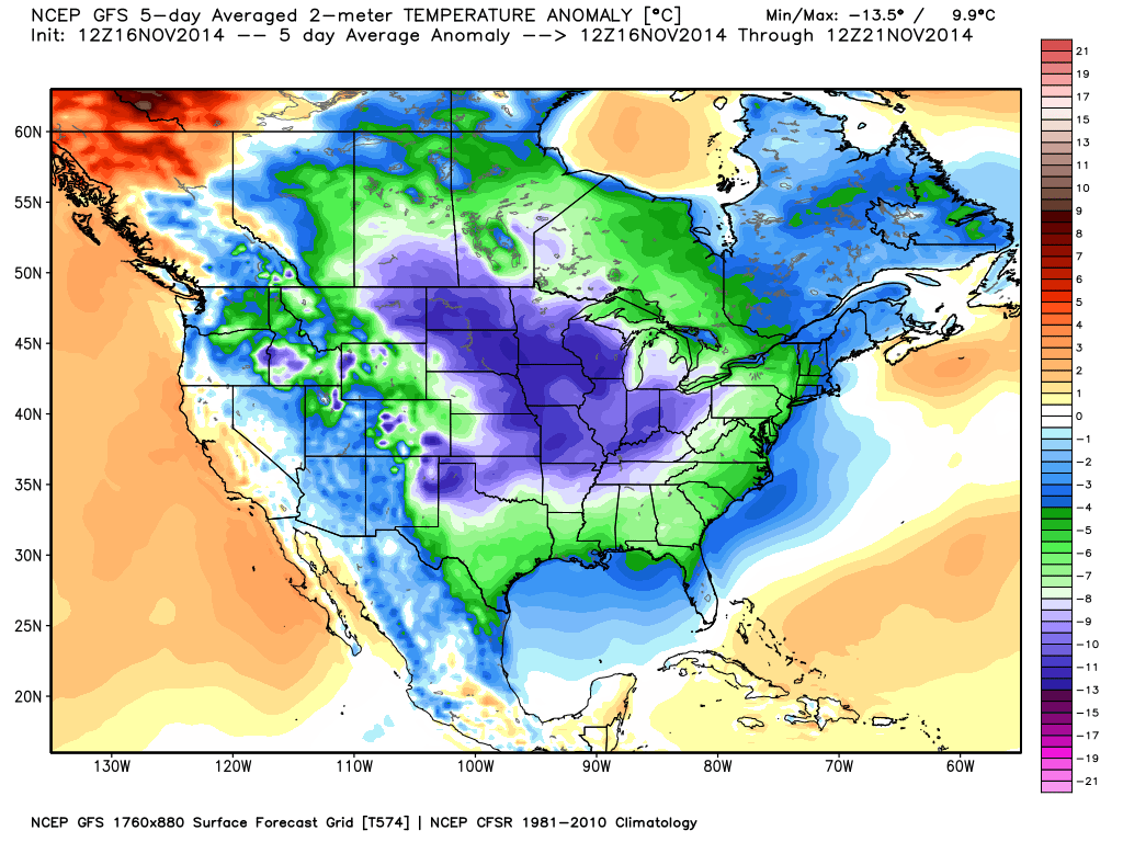
GFS model forecast of 5-day average temperature departures from normal through Friday, Nov. 21, 2014 (Weatherbell.com graphic).
Heaviest snow amounts over the next 5 days will be to the lee of Lakes Ontario and Erie in the lake effect snow belts, where 1-2 feet of snow is possible mainly Wednesday through Friday:
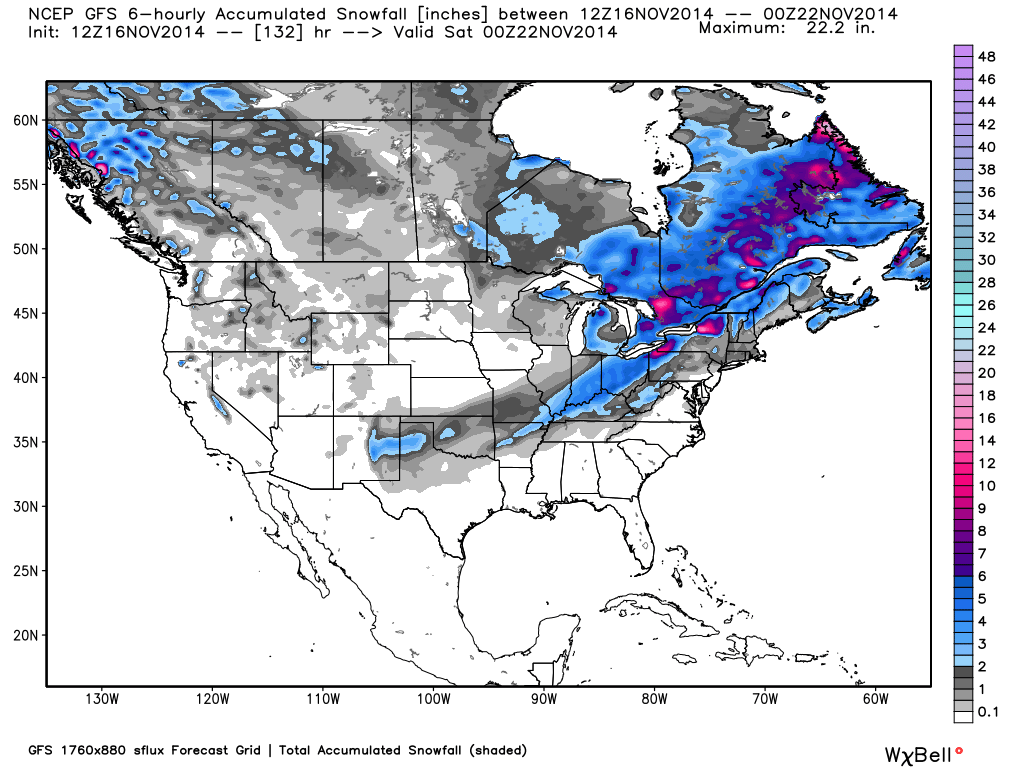
With repeated reinforcements of cold air rotating through the U.S. out of Canada, relief from the winter-like weather is at least a week away.
Here in southeast Alabama the Wednesday morning low is forecast to be 21 F(-6 C) which is only 3 degrees F above our November record low of 18 degrees F(-8 C).
In the stratosphere can see the beginning of the next wave, which pushes south the jet stream.
http://www.cpc.ncep.noaa.gov/products/stratosphere/strat-trop/gif_files/time_pres_WAVE1_MEAN_OND_NH_2014.gif
There has been also an increase in cosmic ray (GCR).
http://cosmicrays.oulu.fi/webform/monitor.gif
In Butte, Montana this is a very early for a cold wave of this extent. We have had lows of; -19, -18, -18, +9, -17 and -12 this morning. Thankfully it will warm up this week.
Amsterdam in Holland, Europe is still warm after a ridiculously hot October. Weather talk…
Ansgar, I bet you will not be here to report when the cold hits Amsterdam.
Hey, Ansgar buddy, turn off the heat in your quarters for the winter. I’m sure “global warming” will save your (insert body part of your preference).
There will be no warmth in the Netherlands and Europe.
http://www.cpc.ncep.noaa.gov/products/precip/CWlink/daily_ao_index/ao.obs.gif
Ren,
A brief description of what the graph is detailing would help us lay folk. Thanks.
This is weather, but it is more relevant to climate than Europe bc much of the European climate is modulated by the gulf stream that strengthens when North Atlantic Deep Water gets more dense by cooling or salty. Thus your weather is not a function of global processes and is difficult to understand. If it warms in the tropics NADW gets saltier Europe warms, if it gets colder in the north atlantic water is denser it warms. If it warms globally and ice melts to the north then fresh water inputs reduce density and you get cooling. In other words European weather is very difficult to interpret in relationship to global climate change. But i can assure you last time we hit a major solar minimum (Maunder) the priests eventually had to come out and throw holly water on the advancing glaciers to save valley cities. Just like the 8.2k event was a time of rapid warming and ice melting and for a time europe was counter trend and started getting cold again bc the NADW slowed subsidence and the gulf stream weakened. Point is not all weather is related to climate but some is more than others.
The “Obama effect”?
Temp here was 15° F this morning – central Washington – but all we get on the map is a stinking air stagnation advisory. Thanks a lot.
If it is 10 to 20 degrees below normal here, because this polar air isn’t where it normally is, wouldn’t it be 10 to 20 degrees above normal in those areas?
http://earth.nullschool.net/#2014/11/21/0900Z/wind/isobaric/70hPa/orthographic=-81.61,77.14,365
http://abcnews.go.com/US/ice-visible-lake-superior-weeks-ahead-schedule/story?id=26939239
First ice already forming on Lake Superior over the weekend weeks ahead of schedule