UPDATED 11 a.m. EST with GFS model forecast.
There is no question the snowstorm just entering New England will be a big one, and that local snowfall totals will set daily records in many locations.
But are we looking at an all-time storm snowfall record event?
There have been only a couple of New York City storm snowfalls which have exceeded 2 feet (24 inches). This one looks like it might exceed that, but with every 6-hourly weather forecast model cycle the story has changed from an epic storm, to a noteworthy one, then back to epic.
For example, last night’s GFS model run looked like maybe a foot or so of snow for NYC. A major inconvenience, but not an all-time record-setter.
Then, this morning’s higher-resolution NAM model is giving Long Island as much as 3 feet of snow by Tuesday evening, and at least 2 feet in NYC (first two graphics courtesy of Weatherbell.com):

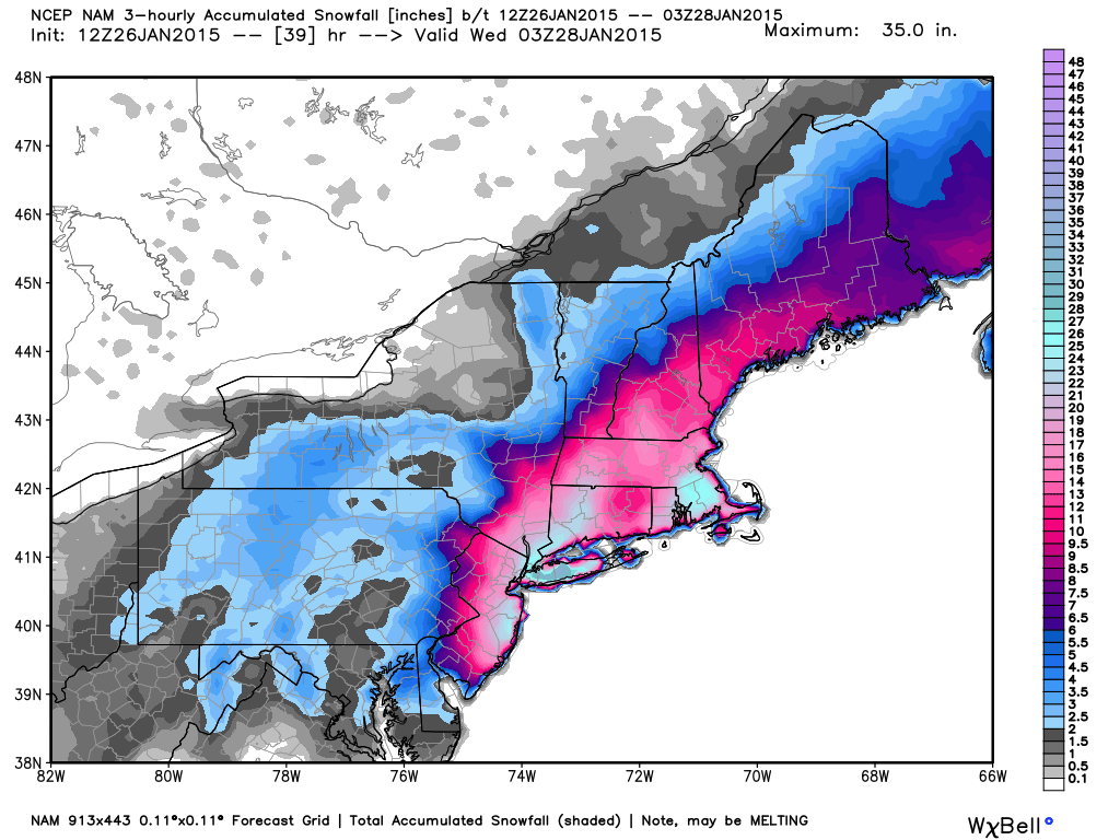
Total accumulated snowfall by 10 p.m. Tuesday (Jan, 27, 2015), forecast by the NAM model on Monday morning.
Then, the GFS model came out with only 6-12 inches for the NYC area.
This indecision by the computer models has been going on for the last few days. All we know for sure is that the most recent forecast is usually the most accurate, but we now have wildly conflicting forecasts from the two most recent model runs. The GFS model has the heaviest snow total — approaching 2 feet — over southeast Massachusetts. Much of the rest of coastal New England is forecast to get about 1 foot of snow:
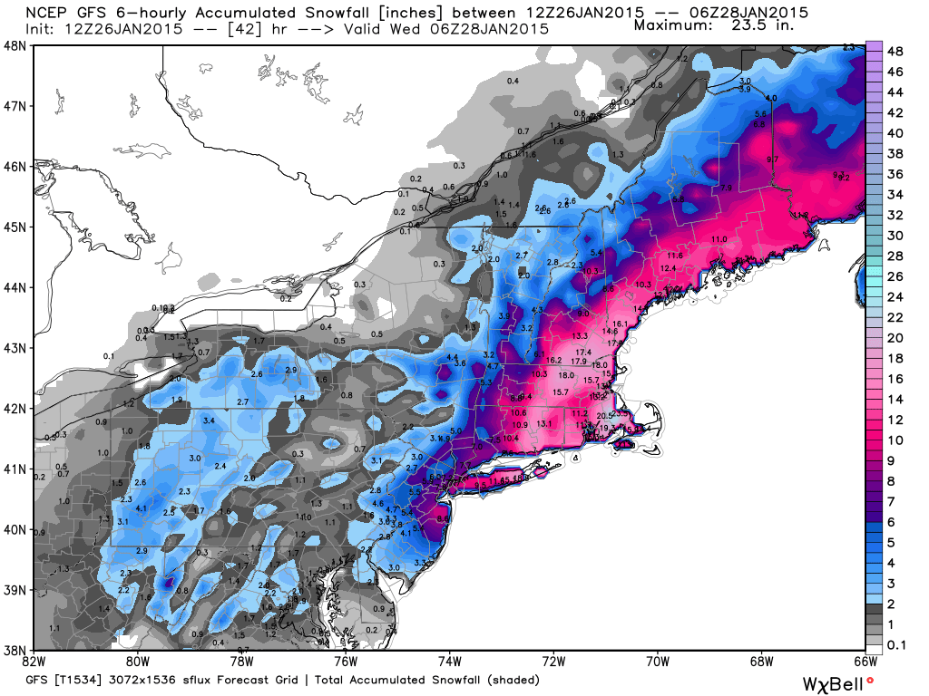
Which model is usually better? For this kind of event, the GFS model (less snow) is usually (but not always) more accurate.
Finally, we have the NWS multi-model product (using over 50 different models and model ensemble members…even using ECMWF) which comes up with sort of a best-estimate of the total snowfall (click for full-size):
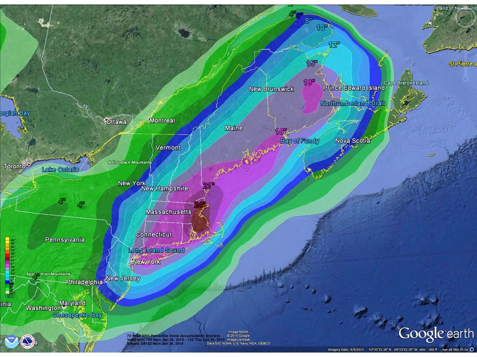
Note that it is calling for 15-18 inches for the NYC-Long Island area, increasing to 2 feet around Boston.
The Long Island snowfall record was smashed on Dec. 20, 2009 when just over 2 feet of snow piled up.
In New York City, many snowstorms have produced 15 inch snowfalls, but only a couple have produced 2-foot snowfalls. In Feb. 2006, the all-time record was set at just under 27 inches. In 2nd place, December 26-27, 1947 saw a 26 inch snowfall.
High winds will make the current storm worse than normal for a snowstorm, with winds easily gusting over 30 mph in NYC, but Long Island and portions of coastal New England can expect 50+ mph gusts. In this kind of weather situation, it is also likely that lightning and thunder will occur in some locations. Most of the snow will fall tonight and early tomorrow.
What I’m dreading is for the next week reporters are going to be asking me about the role of global warming in all of this. Well, if the weather conditions were only 5 deg. or so warmer, we would be talking about a wind and rain non-event. But with colder air, it will be a major snowstorm.
Now, if you really believe global warming causes colder conditions, I have a snow-covered bridge in Brooklyn I’d like to sell you.
With the media now in full-panic mode, over three thousands flights cancelled, and Connecticut banning all auto travel after 9 p.m., it will be interesting to see how all this plays out. Say, with tomorrow’s photos of the stranded cars:
Is someone selling your one-dimensional model?
http://phys.org/news/2015-01-peer-reviewed-pocket-calculator-climate-exposes-errors.html#firstCmt
http://www.scibull.com:8080/EN/abstract/abstract509579.shtml#
No, from a quick perusal of their paper it appears their model is zero-dimensional…just the surface temperature. I still need to find a day to program it up and see what kinds of numbers it spits out.
Seems to come up with similar answers as in your “Blunder” book.
GFS model has been quite bad. The recent forecast of 6to 12 inches is absurd. For my money New York City will receive over 20 inches from this event.
It is not only the snowstorm in New York, where the model forecasts are variable. There will be also a possible snowstorm in the middle Europe on Thursday, where the snow forecasts range from just one to several tenths of inches for lower levels (between weather models and all other available forecasters). There you can see, how precise weather forecasts are just a few days in advance.
The bottom line is the models still DO NOT have the ability to forecast with any consensus or precision even one day before a major event because the atmospheric processes are to complicated even over this length of time.
Seasonal forecast are worse and future climatic forecast are useless.
warmer climate=more water vapour
more water vapour= more precipitation
winter+more precipitation=more snow
sergei, pay attention to the AGW “science”: Children just aren’t going to know what snow is.
https://www.yahoo.com/news/severe-la-nina-weather-events-pacific-may-double-161250881.html
Global cooling via global warming is a interesting topic. Its almost like the modellers are priming the public for cooling to protect their dogma. Of course this model in the paper represents one groups work and in reality there is no union or grand plan
To get an idea how they put together their forecast, here’s a portion of the forecast discussion local NWS mets put out at 10 am EST.
http://forecast.weather.gov/product.php?site=OKX&issuedby=OKX&product=AFD&format=CI&version=1&glossary=1&highlight=off
NWP GUIDANCE HAS SHOWN A LITTLE MORE SPREAD THAN ONE WOULD LIKE TO
SEE AT SUCH A SHORT RANGE. MUCH OF THE 00Z GUIDANCE LOWERED QPF
AMOUNTS FOR MUCH OF THE REGION…WHICH WOULD MEAN LOWER SNOW
TOTALS. HOWEVER…THE 00Z ECMWF REMAINED VERY CONSISTENT WITH ITS
PREVIOUS RUNS. IT DID LOWER QPF SLIGHTLY…BUT THE OVERALL EVOLUTION
OF THE SYSTEM REMAINED SIMILAR TO ITS 12Z RUN. DID NOT WANT TO MAKE
DRASTIC CHANGES TO THE EXPECTED SNOW AMOUNTS AND HEADLINES WITH
JUST ONE MODEL CYCLE. IN FACT…THE LATEST 06Z NAM HAS COME INTO
CLOSER AGREEMENT WITH THE 00Z ECMWF. THE 21Z AND 03Z SREF MEANS
REMAINED SIMILAR TO THE 00Z ECMWF AND 06Z NAM.
THE 00Z GFS APPEARS TO BE A FAST NE OUTLIER. IT MAY ALSO BE
SUFFERING FROM CONVECTIVE FEEDBACK AS THE SURFACE LOW FOLLOWS QPF
MAXIMUM OFFSHORE…AND DOES NOT SEEM TO GET FULLY CAPTURED BY THE
UPPER LOW.
STILL ANTICIPATE THE LOW TO UNDERGO RAPID INTENSIFICATION AS THE
PARENT UPPER LOW CUTS OFF ALOFT NEAR THE MID ATLANTIC COAST
TONIGHT. THE LOW STALLS SE OF MONTAUK LATE TONIGHT INTO TUESDAY. A
PROLONGED PERIOD OF MODERATE TO HEAVY SNOW IS EXPECTED ON THE NW
FLANK OF THE LOW…IN THE DEFORMATION ZONE. THE MID LEVEL LOW
CENTERS AND INTENSE MID LEVEL FRONTOGENESIS WILL PROMOTE HEAVY
SNOW BANDS…BUT IT IS IMPOSSIBLE TO PREDICT THEIR LOCATION THIS
FAR OUT. MODELS ALSO HAVE A TENDENCY TO NOT SPREAD THE BEST LIFT
FAR ENOUGH NW IN INTENSE CYCLONES.
WITH ALL OF THIS IN MIND…DID LOWER SNOW TOTALS SLIGHTLY IN
COLLABORATION WITH SURROUNDING OFFICES AND WPC…BUT WE ARE STILL
EXPECTING AN OVERALL 18 TO 24 INCHES…LOCALLY HIGHER WHERE BEST
MESOSCALE SNOW BANDING SETS UP. SNOWFALL RATES OF 2-4 INCHES PER
HOUR EXPECTED LATE TONIGHT INTO TUE MORNING.
thanks, this is useful input.
To add a little perspective, Long Island is a terminal moraine.
A portion of the forecast discussion by local NWS mets on this storm at 10 am EST.
http://forecast.weather.gov/product.php?site=OKX&issuedby=OKX&product=AFD&format=CI&version=1&glossary=1&highlight=off
NWP GUIDANCE HAS SHOWN A LITTLE MORE SPREAD THAN ONE WOULD LIKE TO SEE AT SUCH A SHORT RANGE. MUCH OF THE 00Z GUIDANCE LOWERED QPF AMOUNTS FOR MUCH OF THE REGION…WHICH WOULD MEAN LOWER SNOW TOTALS. HOWEVER…THE 00Z ECMWF REMAINED VERY CONSISTENT WITH ITS PREVIOUS RUNS. IT DID LOWER QPF SLIGHTLY…BUT THE OVERALL EVOLUTION OF THE SYSTEM REMAINED SIMILAR TO ITS 12Z RUN. DID NOT WANT TO MAKE DRASTIC CHANGES TO THE EXPECTED SNOW AMOUNTS AND HEADLINES WITH JUST ONE MODEL CYCLE. IN FACT…THE LATEST 06Z NAM HAS COME INTO CLOSER AGREEMENT WITH THE 00Z ECMWF. THE 21Z AND 03Z SREF MEANS REMAINED SIMILAR TO THE 00Z ECMWF AND 06Z NAM.
THE 00Z GFS APPEARS TO BE A FAST NE OUTLIER. IT MAY ALSO BE
SUFFERING FROM CONVECTIVE FEEDBACK AS THE SURFACE LOW FOLLOWS QPF MAXIMUM OFFSHORE…AND DOES NOT SEEM TO GET FULLY CAPTURED BY THE UPPER LOW.
Sorry for the double post. Thought I lost the first one.
As one can see from those discussions, they take many models into account when making a forecast, as well as determinations from experience with them. There are still levels of uncertainty they have to deal with, but they do their best.
Here’s the top 10 24hr snows for NYC.
26.9 FEB 11-12 2006
25.8 DEC 26-27 1947
21.0 MAR 12-13 1888
20.9 FEB 25-26 2010
20.2 JAN 7-8 1996
20.0 DEC 26-27 2010
19.8 FEB 16-17 2003
19.0 JAN 26-27 2011
18.1 JAN 22-24 1935 AND MARCH 7-8 1941
18.0 DEC 26 1872
Not 24hr snows, but snowstorms. Oops.
To add to the mix, the Canadian models are advertising around 25-30 cm of snow for the NYC-Long Island area by Wednesday morning. I have been forecasting for more years than I care to remember. Welcome to the real world of forecasting…things are seldom a sure bet. That is why we advertise probabilities.
Thanks, Dr Spencer. Nice models.
How much are you asking for that bridge?
I’m sure global warming will clear it up for April, March at the latest. Then I’d flip it!
No sale, I guess?
I just saw Bill Nye on MSNBC saying that this snowstorm was probably caused AGW and would be incredibly expensive! 😉
Ninety seven percent of science guys agree. Actually it would have be 3 feet, but diminished by global warming (see today’s headlines).
Snow-Covered NYC Deserted, Streets And Sidewalks Passable
Your average models appear more accurate than the 3′ warnings. As they say, bad news sells.
This is my first visit to your website and I appreciate finding this information online. I have been somewhat a follower of Richard Lindzen and heard him recently on a radio interview. I was very interested to hear him explain how rising sea levels are probably due more to shifting and moving land mass than by melting sea ice, etc. I would like to learn more about that.
Also, having little or practically no understanding of the sciences and how they might be impacting our weather, I am not sure how world wide temperatures are collected. Is all temperature information compiled from satellite data? Is any climate data still processed by local observation?
I also wanted to point out that John Kerry who is circling the globe like Paul Revere telling all nations that “warming is coming” had an embarrassing run in with the City of Boston Streets Department. It seems that John forgot to clear approximately 2 feet of freshly fallen snow from the sidewalk in front of his Beacon Hill Mansion. He’s a busy man you know!
>Now, if you really believe global warming causes colder conditions, I have a snow-covered bridge in Brooklyn I’d like to sell you.< (Dr. Spencer)
Not possessing a scientific mind I have to resort to my own view of common sense. It seems to me that the climate change proponents want to have it both ways. Global warming causes less or no snow or global warming causes more snow events. It is like saying, "heads I win, tails you lose". It seems to me that part of their science is based on their own qualifications that assure that they are right no matter what the evidence is.