
 Home/Blog
…but the approaching La Nina might extend the global warming pause to 20 years.
Even though global average tropospheric temperatures are rapidly falling now as La Nina approaches, it is usually the second calendar year of an El Nino event that is the warmest, especially in the satellite record of tropospheric temperatures. This is because it takes a couple of months for all of the unusually warm Pacific surface water to transfer its extra heat to the atmosphere, pushing peak atmospheric temperatures into the second calendar year of an El Nino event.
While 2015 was only the 3rd warmest year in the satellite record (since 1979), 2016 might well beat out 1998 as the record warmest.
I computed just how fast average cooling must be for the remainder of this year for that to happen (or not happen), at least in our UAH dataset; the RSS satellite dataset would give somewhat different results. The following graph shows that if steady, linear cooling occurred from the May 2016 value of +0.55 deg. C to reach +0.20 deg C in December, then 2016 would edge out 1998 for a new record warm year (ignoring measurement uncertainty).
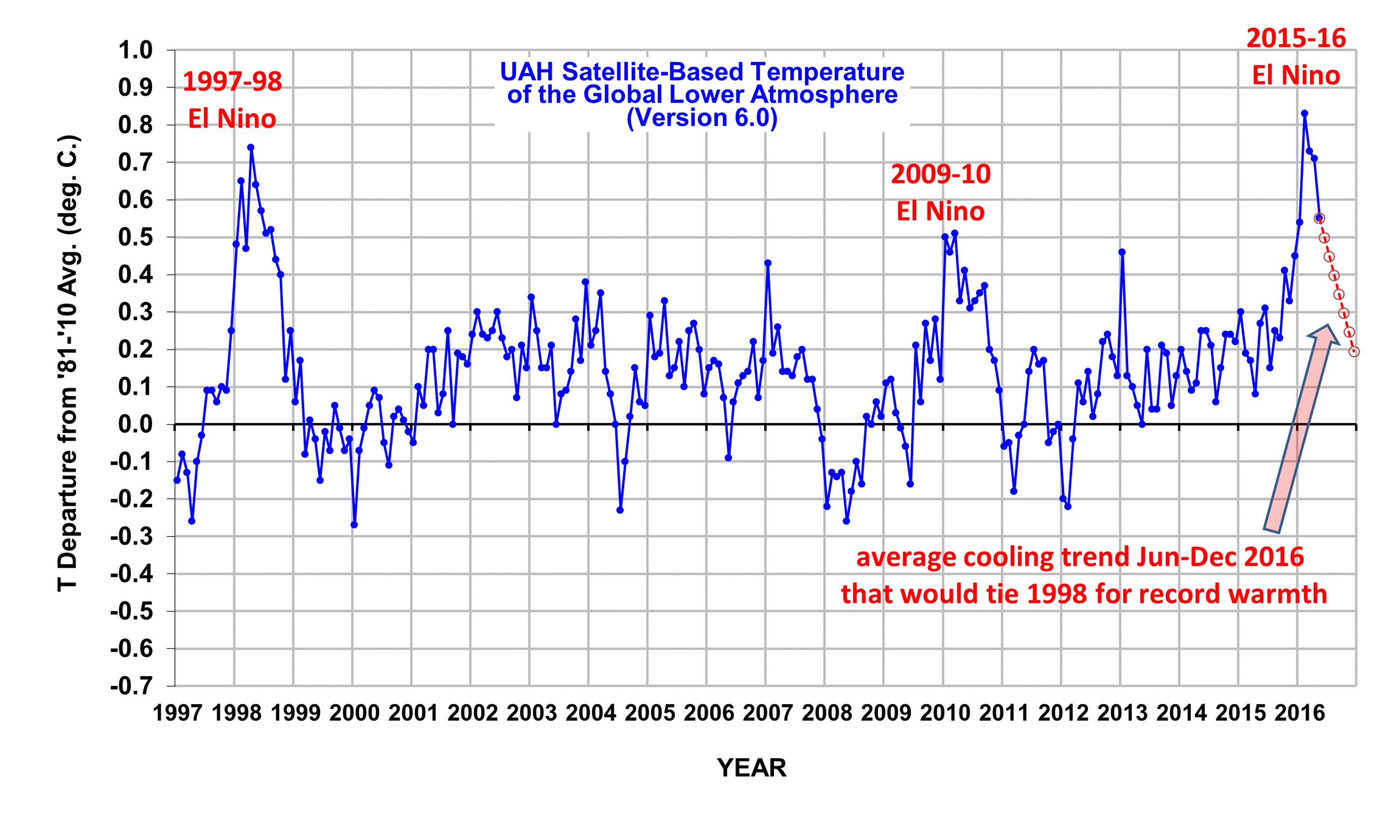
If linear cooling ended up resulting in +0.19 deg. C in December, then we would avoid a new record warm year.
How likely is it that cooling will progress at such a fast rate? Examination of previous El Nino-La Nina transitions suggest it would be unusual, but not out of the question. The latest La Nina forecast suggests fairly rapid onset of La Nina conditions, possibly by next month.
Nevertheless, if I had to make a prediction one way or the other, I would bet that 2016 will not experience that rapid of a rate of cooling, and will edge out 1998 for record warmth. I’d be happy to be wrong, though.
And, of course, if we go into prolonged La Nina conditions for the next 2-3 years, we might well be debating the meaning and significance of a 20-year pause in global warming in another year or two.
For the reminder of the year, I will try to include updates to this graph in my usual monthly global temperature updates. This will provide a visual guide to how we are progressing toward a possible new record warm year.


