The last couple of days have not made me very confident in the predictions of engineers associated with the Oroville Dam.
While I am a climate researcher, and not hydrologist, it took me less than an hour midday yesterday (see comments here) to estimate that the emergency spillway would be breached around 9 a.m. PST this morning. I was off by an hour…it was breached at 8 a.m.
But engineers were leaning toward the lake level never getting that high (901 ft.)
This kind of calculation isn’t rocket science. As long as inflow into the lake exceeds outflow (both of which are monitored hourly), the lake level will rise.
Why were engineers reluctant to predict the (admittedly historic) event?
Now let’s talk about something that is much more uncertain…the damage now occurring as water continues to erode the dam under the gaping hole which has split the main concrete spillway:
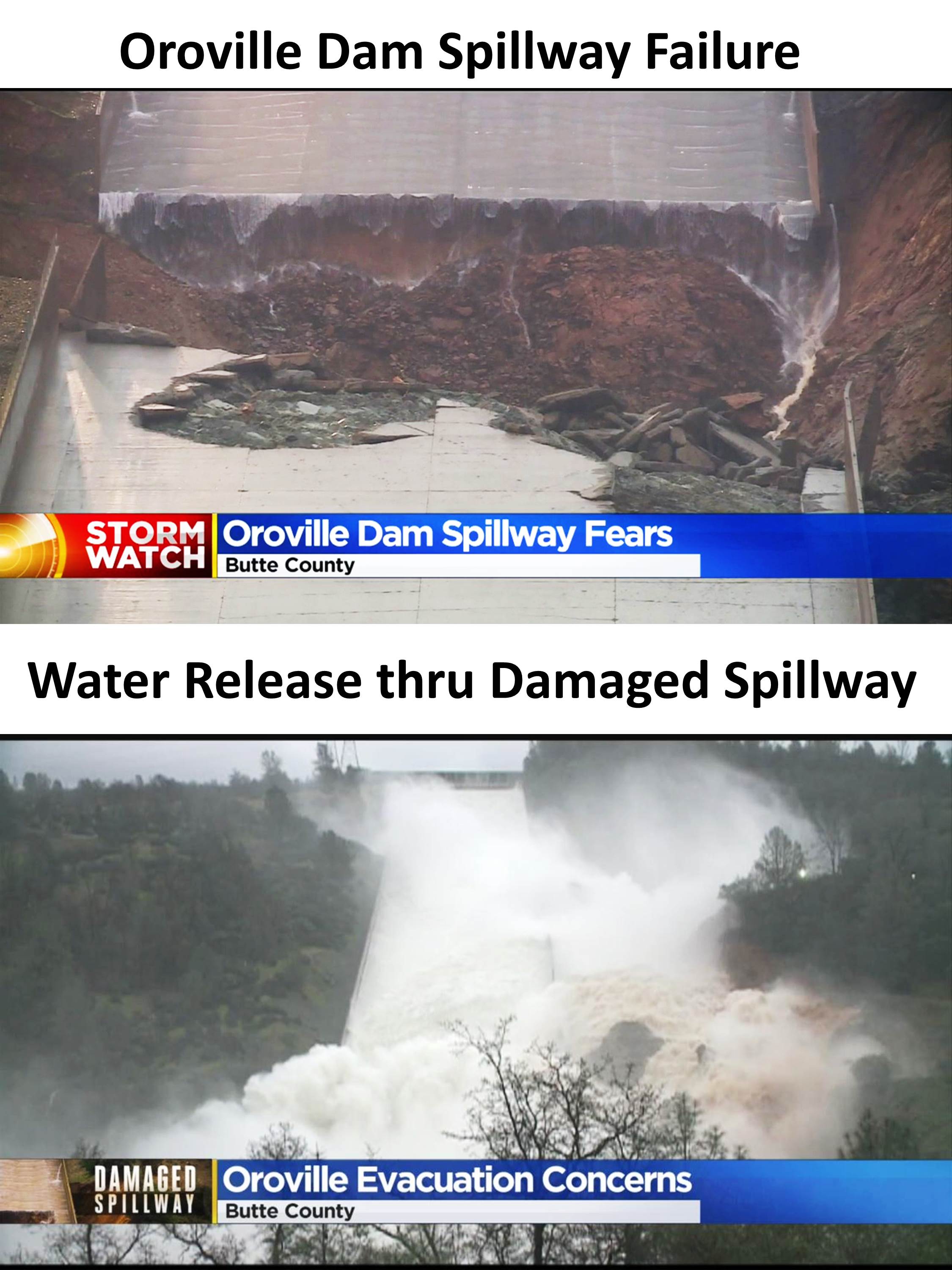
One dam engineer who has worked on similar dams is worried that this is a structural threat to the dam.
Furthermore we haven’t even entered snow melt season yet, and already Lake Oroville has exceeded its 100% capacity (here’s yesterday’s plot, at 97%):

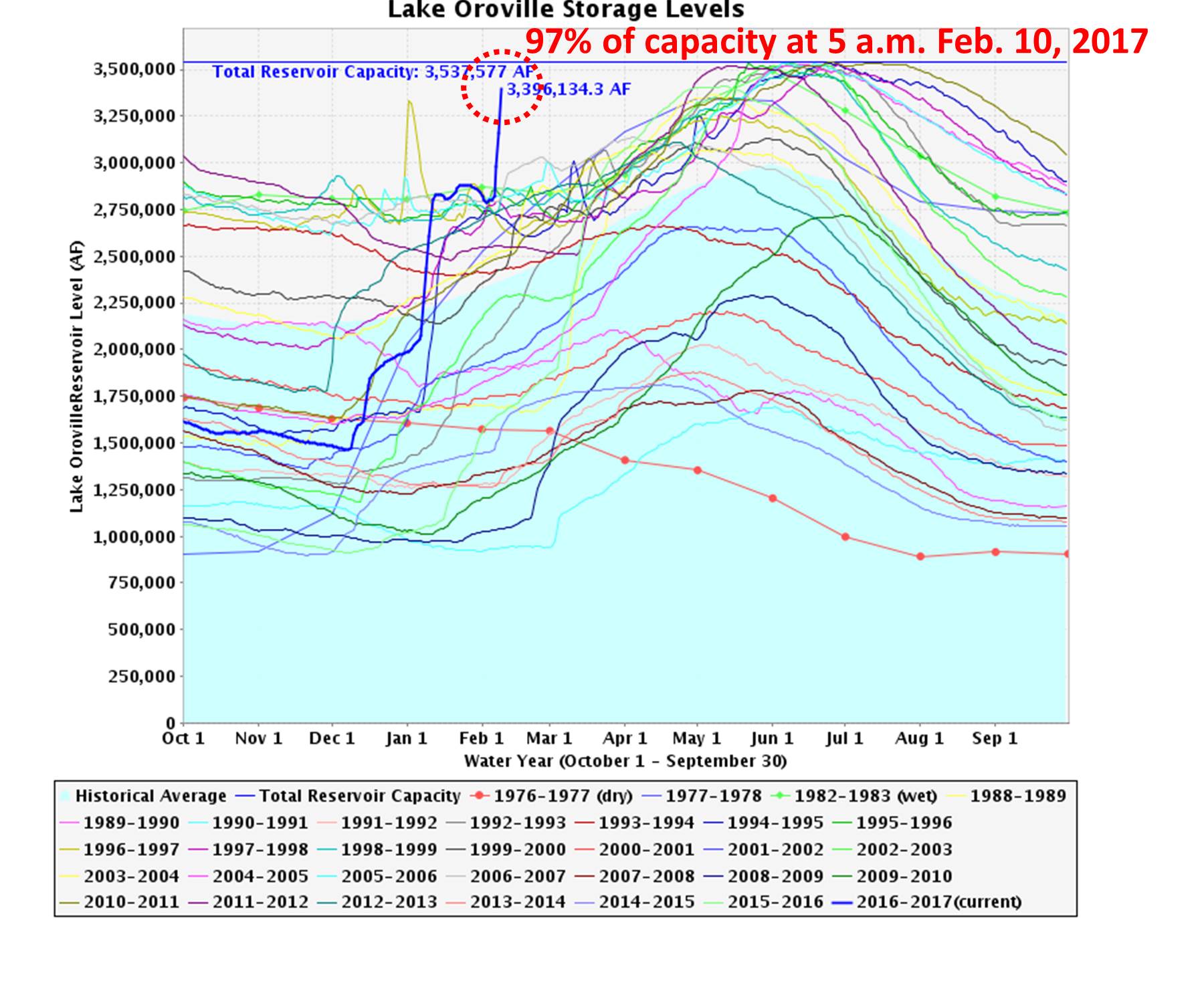
Lake Oroville water levels in different years, showing the current level is unprecedented for so this date, and rapidly approaching a 100% full state.
So, I am merely raising the question: if engineers were reluctant to predict the current topping of the emergency spillway — a relatively benign event that was rather easily predicted — how much confidence can we have that the damage to the main spillway won’t compromise the dam?
I think engineers are going to have to be a little more forthcoming about whether such a failure — which threatens thousands of people immediately downstream — is indeed possible in the coming weeks and months as the massive mountain snowpack melts and continues to fill the lake — and continues to erode the spillways.
It makes one wonder if the internal reports by the engineers to the management made it out to the public.
Runing the numbers from the plots on the graph “Lake Oroville Storage Levels” and knowing that the current discharge from the damaged spillway is 100,000 cubic feet / second. The entire contents of Lake Oroville could be emptied in about 18 days at this rate. Mid-week another 5-7 inches of rain are going to make another near vertical spike on the plot like the first three, those took 68 days from Dec.7th or so till Feb.12th to add about 2,121,577 acre feet to put us over the top. Seems to me there will be a short window of time after this next storm to effect necessary repairs to the washed-out section of spillway and secure it to bedrock (or tree stumps)and prepare defences for flood control over and above all historic levels downstream. Just get rid of as much water now, during and after this next storm, do a new spillway and let the lake fill some, test the spillway and get ready for three months of snow melt. Impose a tax on No. Cal water to So. Cal consumers and use the money to build a real dam. Reminds me of making dirt dams in the street gutter to try and block run-off.
Engineers originally predicted it would be used actually.
Then they said it may not be used bease they increased the release amount and weather was scaling back.
They then had to scale back the release of the spillway so to be extra careful of erosion from the failure to not affect the power line infrastructure.
If you’re really watching there are almost no questions to be asking
Only 24 hrs in advance should have been an almost certain prediction of breaching the emergency spillway. Doesn’t matter that it stopped raining, it takes time for runoff from the watershed to slow down. Do the math.
Yah, they knew 4 days ahead that they would use it. Correct. They announced it.
Check the facts and time line.
They also reannounced that the emergency spillway would be used well ahead of your blog entry. Well ahead.
You got no story
Not *my* story, Brian…9 a.m. Friday: “At this point in time, with the amount of inflow compared to the outflow and Mother Nature holds fast and theres no precipitation the next several days, theyre predicting the emergency spillway will not have to be used”
Read more here: http://www.sacbee.com/news/state/california/water-and-drought/article131941279.html#storylink=cpy
Whenever they say a dam won’t break believe the opposite and prepare. I was I Baldwin Hills dam break in 1963 in Los Angeles. They left choice to evacuate up to the Los Angeles police chief. They weren’t sure if it was going to break or not. We would’ve all died had the police chief not evacuated the neighborhood
Levee in New Orleans just after Hurricane Katrina is another great example.
You just said;
“Only 24 hrs in advance should have been an almost certain prediction of breaching the emergency spillway. ”
Here’s 30 hours ahead, by UK media mind you. Local media was calling it with state officials days ahead.
https://www.google.com/amp/www.dailymail.co.uk/news/article-4209546/amp/Nations-tallest-dam-Lake-Oroville-damaged-amid-storms.html?client=ms-android-uscellular-us
I don’t have to answer anymore obviousness. Plz research more b4 putying out erroneously titled blog entries full of redundant questions
Sorry to pick on u, but the most obvious example of you being wrong here is that they brought in heavy equipment 4 days ago to start clearing trees in the path of water downstream of the emergency spilkway runoff. They wanted to have as little dirt, trees and depris go into the Feather river as possible.
This is evidenced in articles and pictures from days ago.
Yes, I’m fully aware of that, Brian. So why then 24 hrs in advance would they be backing off? You do realize a 1 day prediction will be more accurate than a 4-day prediction? I’m suggesting that politics are involved in what the public is being told. -Roy
We’re watching the beginning phases of a catastrophic failure. The dam will erode and fail.
“For a successful technology, reality must take precedence over public relations, for Nature cannot be fooled.”
Richard Feynman.
How can we know? What is the bedrock and how porous is it? How much water is going to end up going over this thing? Nobody knows the answer to question #2 being weather dependent. But how about question #1?
Yep. How that area at the spillway breech erodes seems to be an area of massive uncertainty. I for one would not be sitting around taking pictures downstream. Reminds me of Mt. St. Helens. Best off to be far away or to be prepared to move at a moments notice at least.
there is no bedrock. Oroville is an earthfill embankment dam, which is why the concrete spillway failure is a concern due to headcutting and upstream progression of the erosion.
Bedrock is visible in photographs.
Earth filled does not mean they built all the hills surrounding the dam
yes, you’re correct, it will depend upon how high up the headcutting erosion extends before it hits the artificial fill.
Looking at the construction site,
https://books.google.com/books?id=9yADAAAAMBAJ&lpg=PA86&dq=huge%20tentacled%20scar%20on%20the%20forested%20surface%20of%20the%20feather%20river&pg=PA86#v=onepage&q=huge%20tentacled%20scar%20on%20the%20forested%20surface%20of%20the%20feather%20river&f=false
it appears as if all the area to the right of the spillway was construction fill?
I agree. The area to the right of the dam face is likely graded and filled. The emergency spillway will erode that area severely if it is not directed to the new cut. I am more concerned about erosion due to the failed main spillway and having it erode across the face of the dam.
Brain (Brian), R U still awake. Remember saying “You got no story”
Evacuation orders issued….seems what doctor Spencer was saying was right on target.
No apologies necessary….we always consider the source of nonsense utterances.
Download the USGS geology map of the dam area.
There is, of course, bedrock…there is bedrock everywhere in the world if you go deep enough.
The dam itself is fill of course, but that is not threatened.
The concrete structures of the spillway and the entire dam are actually build upon metamorphic volcanic rock, which is solid as a….well a rock.
But there is a layer of topsoil and overburden that we’ve seen erode heavily where the main spillway has been breached but once it’s down to the metamorphic volcanic rock, it wont go further
I don’t think it’s time to panic yet. (However, if I lived downstream, I’d probably be loading the car with all the stuff I’d rather not get washed away and go visit my brother in Oregon for a week.)
The spillway washout is quite a ways from the dam, so there’s a good chance the dam isn’t in trouble yet. As long as the washout doesn’t creep uphill, it may stay serviceable, though I think they shouldn’t increase its flow until it is time to panic.
The dam is under maximum pressure, but its not being rained on. It’s probably okay. I read something about the construction yesterday, apparently a coffer dam that was built early in construction is still there under the read dam. That may or may not be useful, I’d have to read things in more detail.
The emergency spillway is further away than the main spillway. It will be interesting to see how that holds up.
All in all, I’m sure glad I don’t operate that dam!
It’s interesting to read about recent dam failures, although I suppose how a dam fails would depend on the type of dam. I do suppose there will be some sort of problems/warnings in the case of a failure.
https://en.wikipedia.org/wiki/St._Francis_Dam
https://en.wikipedia.org/wiki/Teton_Dam
I was in the 1963 Baldwin Hills dam break. The engineers failed to put in a thicker lining to consider grouping movement from earthquakes and nearby oil wells. We were barely evacuated in time due to overconfidence in the dams state of the art trumpeting
Glad you made it out Cheryl! California has a number of challenges regarding building dams.
The below Popular Mechanics (page 87) describes how the Oroville dam has a system of monitoring devices to measure settlement and water pressure. Let’s hope they are still functional. Perhaps they are a reason for the confidence in the integrity of the dam.
https://books.google.com/books?id=9yADAAAAMBAJ&printsec=frontcover#v=onepage&q&f=false
The Teton Dam should never have been built. The surrounding rock is extremely porous and would be difficult to seal. The leakage through it caused the failure.
not time to “panic yet”? I totally agree. But notice how officials keep saying the dam is in no danger of “imminent” failure. OK, how about in the coming weeks and months? I wouldn’t want to be living near that river.
Being a government project no one will be held responsible. Imagine if it was privately owned. All h would break loose.
The South Fork Dam, whose failure that caused the Johnstown Flood, was privately owned. The owners of the dam were never held legally responsible; the court ruled its breach was an Act of God. There was no legal compensation for the survivors. 2,209 dead.
With today’s population, that number of deaths would be equivalent to 11,600.
Almost four 9/11s.
https://en.wikipedia.org/wiki/Johnstown_Flood#/media/File:Johnstown_flood_debris.jpg
Roy, are you implying that State-funded “scientists” could be wrong?
Because private industry has never caused any problems, right?
Today’s feature article in the Los Angeles Times starts out with:
Looks like the CA State Department of Water Resources didn’t consult with Roy.
Gary, you draw a conclusion by ignoring more your LA Times article – right after the bit you decided to stop the quote at:
“Though optimistic that dam operators wont have to use the emergency spillway over the weekend, crews continued to prepare the area just in case.
Workers with the California Department of Forestry and Fire Protection used heavy equipment to clear trees and brush from the hillside route the water would take if it overflowed the 1,700-foot-long top of the emergency spillway.
Utility workers were preparing to move transmission poles out of the way. Booms and boats were brought in to collect debris and keep it from clogging the pool at the base of the dam and downstream diversion gates.”
Spencer is a researcher dealing with satellite microwave sensors. California Department of Water Resources has been dealing with their geology, hydrology and development patterns for quite some time.
One might also note that the ’emergency spillway’ is not hardened. Could potentially be a serious erosion issue here.
“When will we, at last mandate proper maintenance and inspection of these high hazard and medium hazard dams? Why are we willing to suffer a loss of hundreds of millions of dollars to save a couple of dollars on proper and responsible dam safety and repairs?
Whatever you may hear, this is a significant event which could be horrible in its scope and its magnitude. Let us pray that it does not breach, and let us hope that, at last people are sufficiently concerned to act.”
Scott Cahill
American engineers are good in cleaning up the mesh.
Dutch engineers are good in preventing the mesh.
It’s a way of living.
That’s why our dikes are designed tot withstand a once in 10000 years extreme whether event.
That’s why we pray:
“Lieve Heer geef ons ons dagelijks brood en af en toe natte voeten.”
“Dear Lord give us our daily bread and once in a while wet feet.”
just to remind us to build better dikes.
My thoughts are with those living beneath the dam.
I mean weather event
sh*t I mean mess
Fulco – we knew at once what you meant.
The capability of Dutch engineering in past centuries has always amazed me.
My experience with dam design indicates that the 10,000 year flood scenario is a standard criterion. But…where do you get the data? In the low head designs I dealt with in Michigan it was based on a worst possible case storm sitting directly over a catchment basin. The worst possible case scenario was predicated on climate modelling…so much rainfall, so much humidity, wind currents etc. Then everything is artificially scaled up and the 10,000 year flow becomes the design criterion. The trouble comes from things like concrete rot/cancer, piping at concrete interfaces, void formation, ephemeral springs etc. Concrete is frequently subject to rot because of excess glass in them. If limestone, for example, has volcanic ash…bad. If the sand has lots of quartz with undulatory extinction patterns, the quartz is considered weak. Neither of these issues were well recognized when the dam was constructed.
Next, the dam was undoubtably not designed with good synthetic drainage layers in the base and subgrade lifts. Geotechnical engineering did not include much in the line of what we now call geo-synthetics. So…even if the soil was properly graded and the dam was well constructed and well located the designers of the past were not in a position to know the amount of local-head seepage infiltration, soil subgrade piping and concrete rot that would affect their final product. they might monitor for settlement or whatever but it is not likely that anyone hunted for voids below the concrete or ran IR images over the dam during wet season to predict seepage flow pathways. But what do I know…I only built landfills and cried for 10,000 design criteria…and the engineers all shook there heads…and the townspeople all said they didn’t want those stinking things nearby…so all the designs in the world and all the site studies possible are pretty much lost on both managers and the public. Whatever actually gets built is a miracle onto itself. I satisfied my worries by helping to rebuilding dams that were on the verge of failing. Too bad there are so many and there isn’t money to do anything. Remember…polygonal cracking in your concrete is not a good sign…8-10 years is how long it takes to form.
Talk about alarmists!
You guys are predicting doom and gloom based on dodgy predictions.
There is no evidence that the dam will fail.
This whole story is simply more evidence of a conspiracy by the UN/muslims/communists to institute world government and take away our firearms.
The rains will stop, the flows will decrease and the dam levels fall – just as they always have and always will – just as the good lord above planned.
After all, water is what we need and makes life possible on earth.
Stop trying to scare us.
Northern California has been hit by one front after another. Not only has that brought the current flooding it has brought massive snows in the mountains. So the situation is that the reservoirs are at or above their high levels during the spring thaw when they usually peak and the snow pack hasn’t even started to melt and in fact will be added to some more if things keep up as forecast. Who knows what will happen?Whistling by the grave yard is certainly not indicated because nobody can predict what is to come and how long this situation will last nor how long or strong the flow will be in the long run.
Now this Hoosier has not a lick of skin in this game but I sure know that if I lived nearby down stream from that dam within the possible danger zone I would have my bugout kit ready and think any neighbor that did not a fool.
During WW II a Priest the who’s Parish was downstream from the great Mohne continued to write letters to the local Nazi authorities about how vulnerable the Dam was until they less than politely wrote him back and told him to shut the hell up. One night in May of 1943 when the water behind the dam was near it’s peak his fears were realized. The Father died ringing his church’s bell to warn his flock in a prearranged signal to head for the high ground.
Is suspect somewhat ironically that if the Barnes Wallace, the scientist and engineer who conceived of the idea of bombing that dam and others, and developed the weapon and technique to do so, had been in charge of the construction of the primary spillway at Oroville, we wouldn’t be posting on the subject now.
Ex-NSA whistleblower Jim Stone Freelance, in his blog yesterday: “All the maintenance records on the dam show that the spillway was in perfect condition. Since the initial rupture video shows concrete flying high in the air, I still think the spillway was blown up or sabotaged. This dam has had recent outflows through that spillway of 170, 000 cfs (double Niagra Falls) without issue. For it to self destruct with only 60-70, 000 is a serious reach, I do not believe this was any sort of mishap. Obviously I have no proof of explosives destroying the spillway, or of intentional digging under it by a sabotage crew happened, but can say that is a perfectly rational explanation. Even the engineers are wondering how this happened. That means a LOT.
I have my doubts that this will end well, but also have a fair amount of hope that it will. But this year outflows are likely to reach 300, 000 cfs and with no control over what is going on, well, what can be said? Can the mountain side handle 3-4X Niagra falls? Your guess is as good as mine.”
That is not in fact “a rational explanation”.
and yet, over the years, dams have failed catastrophically and killed thousands of people. It will probably be OK. But if you lived below it would you not be nervous?
yet, heat waves are catastrophic and have always occurred. Just look at todays headlines:
“The New South Wales Rural Fire Service (RFS) is urging residents to prepare for catastrophic fire conditions before it is too late as temperatures across the country are set to break records.
Conditions in parts of NSW could be worse than those preceding Black Saturday
“This is as bad as it gets,” Rural Fire Service warns
Parts of QLD could experience nearly 50C
The RFS said the extreme fire conditions could start from about 11:00am on Sunday and last for up to six hours.
More than 1,000 RFS firefighters are battling seventy-six fires across the state, with 26 of those not yet contained.
http://www.abc.net.au/news/2017-02-12/fire-heatwave-worst-possible-conditions-for-nsw/8262774
This is happening now.
Why should we panic about a theoretical dam collapse when there is obviously no need to panic about a theoretical increase in heat waves (sarc.)?
Double standards at work methinks.
I am a hydropower engineer with a special interest in the safety of spillway gates and a general interest in the safety of large dams. I also know quite a lot about nuclear power stations.
Failures of large dams have killed more than 200,000 people last 50 years. I think they are among the most dangerous things that mankind makes. Failures of nuclear power stations have killed about 50.
Safety requirements for dams and spillways vary from country to country and some of them are, quite obviously, inadequate. Most large dams Including Oroville have radial spillway gates that require a power supply for lifting and can only be raised if an operator presses a button. In my opinion, most power supplies for gate lifting are inadequately secure and all dams should have an overriding system that raises the spillway gates if the water reaches a dangerous level. They don’t. In fact, the US Army Corps of Engineers won’t accept such a system. In many cases, USACE and USBR spillway gates can only be lifted one by one by a gantry crane and a team of experienced operators. I would not assume that they would always be available into the foreseeable future.
At Oroville safety now depends on the rock conditions beneath the emergency spillway and the service spillway. It is most unlikely that the rock is inadequate. But the emergency spillway may become seriously damaged and cut down for a few metres thereby increasing the amount of water being discharged. Judging by Google earth a very large amount of rock (or whatever) would have to be washed away before the situation became really dangerous. The failure of the main spillway chute should should not have happened and might be more serious because it is closer to the dam.
In my view, the chances of a major dam failure somewhere around the world that could kill hundreds of thousands of people are much greater then they need to be. But nobody wants to know.
Every year there are sinkholes…in roads…along gutters. The gutters leak, the sewer pipes below them crack a bit…there is freeze thaw…pretty quick there is a seepage path right at the soil concrete boundary. That boundary is a known preferential seepage pathway by all geotechnical engineers involved in constructing fluid retention systems out of soil or in soil. Nowadays, that pathway is reinforced considerably by using various geo-fabrics-nets or whatever. They work. The use of graded soils against impermeable barriers that are subject to point fluid failures is old technology. The resulting seepage pathways from such a design resembles the networks made by pine beetles chewing the cambium layer below bark. You won’t see it until too late but it is there.
Curb and gutter and dam spillway/raceway design have a lot of parallels. Ever notice where road potholes form…where there is standing water and there is traffic that squeezes the flexible asphalt or rocks the slabs. Little “soil” volcanoes develop over time and the roadway degrades. Notice how much water there was behind Oroville Dam the last week or so? Standing water for a week after a long dry spell when the subgrade has fully consolidated to its minimum void ratio is plenty of time for water to find preferential new seepage pathways that nobody knew about.
For example, the Finwall failures along the crest the levees of New Orleans were only designed for a few hours of submerged conditions. Trouble was…it was high tide and tidal surge. The water stood on one side of the finwalls for too many hours…seepage under the footings and hydraulic overturning stresses distributed along the finwalls finally won out.
Dynamite…gimmie a break…
So…just how different is that roadway pothole example or the finwall example from Oroville whose spillways were laid out over rough volcanic sequences that probably had to be sealed a lot to prevent seepage pathways between the cleavage joints and whose soil compaction standards were designed for one compaction scenario…over or under the Optimum Soil Moisture (OMC) peak…for wet or dry conditions but not both! So how many hours could the soil joints all plugged up with fines stand seepage forces from new cracks in the dam joints from last week’s highwater…remember…dams do creak a bit when they have to withstand high water conditions. So…they make water. Anyway…after some time, undoubtably piping started and it was just a matter of time until the graded soil system failed in a distributed manner…and developed piping pathways…just like the pine beetles. In fact, void spaces develop all the time from natural runoff or high water conditions. They probably developed all along the raceway and particularly over the sharp bends. Those are the weak spots. You can see in pictures the rock and the soil in the “voids” folks were photographed peeking into was red and oxidized. That means it…meaning the soil itself is NOT WATERTIGHT and has probably leaked and oxidized for a long long time before or after being installed. It takes time, oxygen, water and permeablily to achieve a red color. In some places such soil is called an “ultisol” or a “thermisol” if I recall from my work in North Carolina landfills. Maybe it’s good enough…but I would be a bit suspect that red soils are questionable for critical situations.
The red color is due to entry of oxygen into the subgrade as a result of water in the base and subgrade draining away. In order for colored ultisols to develop hosted soil moisture must drain and allow soil voids to develop so oxygen gets in and reacts with the soil minerals. Eventually the soil becomes red. Then when engineers come to use it…well…likely they just run a few tests. But indeed that color by itself is pretty good proof that either the rocky subgrade is not well sealed in long term geological terms….or that somebody thought red soil was ok to use in shorter term engineering terms because of soil testing. In my book redness it is always a sign of a potential drainage and subgrade stability problem. Folks…there is a reason soil is red…it is because it is “rotten”..and water drained from or still drains through it. If water drains and voids fill with air there is a good chance fines will have been piped off. Oh well….somebody probably ran an infiltration test on it and proved it is OK. Sigh.
Thanks for writing this Steve. The risk of “piping failure” on an initial filling of an embankment dam is always there.
This weeks event was an “initial filling” that is: it is the first time water has reached the level of the auxiliary spillway. It then exceeded this level by 1.5 feet. So pore pressures in the main dam are higher than ever before. The other thing I would be asking about is how far the core and filters extend, in the main dam, above the auxiliary spillway crest level.
Also as the erosion from the failure in the main spillway shoot has partially eroded the toe of the area beween there and the main dam, how stable is this area?
Yes, I’d be nervous, and, depending on my homes’ exact altitude above the floor plain, would consider leaving until the situation was clear that there was no danger.
Nice analysis, Roy.
Dr. Spencer,
Can you please try and find out how bad the flooding would be in Sacramento? The press here are out to lunch talking heads. Also if the dam fails how long until the surge hits downtown Sacramento.
Thanks
There is a lot of overbank storage capacity between that dam and Sacramento. Not much head would be left after all those miles.
What about Biggs (not East Biggs)? I’ve read about the time it might take to get here. Any ideas about how high the water could possibly get here in the center of town? We’re trying to get things in our house higher off the ground long term (I worry about the future). I’ve been trying to read as much as I can find on it, but can’t figure it out (although I know it can’t be figured for sure ahead of time). We’re just trying to get a general idea of the possibilities and planning from there. Thank you.
We were told before we had to evacuate by someone in Gridley (5 miles south of us) that we could get 4 or 5 feet in our homes. I don’t know if that was rumor or they heard it from a reliable source. Our elevation is 93′.
Not preparing for the worst is at best foolish. It’s called an “Emergency Spillway” for a reason.
Is preparing for the worst also true for AGW?
Like a moth to a flame eh David? Let’s go down that road a bit. Max Temps are slightly decreasing worldwide, Min Temps are increasing in cities and the Arctic. Sea level is steady at 3mm/yr, increased CO2 is making plants more resilient to drought and agricultural production is at an all time high. Hurricanes are practically non-existent in the Atlantic and never-ending droughts would appear to be at an end. So 100 years from now when me, my wife, kids and probably some of my grand children are dead, we will probably be better off thanks to CO2. The only thing I worry about is the ability of snake oil salesmen to strip ordinary people of their last dame on the flimsiest of excuses.
Yeah I didn’t think so either, but then I saw a video from 1963 when they built that sucker. It’s landfill. Landfill earthen dam, staying put due to it’s weight. Landfill transported by train to the site, tipped over and dumped, then patted down right in place.
You know what else is held in place just by it’s weight? The mountain side underneath that damaged spillway.
And yet there it is with a growing sinkhole.
One gopher hole shy of disaster.
Built on the quick and cheap. (Wanted it done before the friscan’s could organize a Sierra Club).
Another fronts are dangerously close to California.
http://pics.tinypic.pl/i/00869/9gv7b9miegi2.png
Hi – what site is that from, if you would pls? Thanks
http://www.intellicast.com/Local/WxMap.aspx
Oh thanks . . I had that link. Just have too many and forgot.
The dam will fail sometime this week, get your loved ones out of the area immediately.
Alarmist!
Best I can see….only the Spillway is on the verge of failing….check the photos…another couple of feet and the pothole/erosion points will meet the glacis/slope of the spillway. When that happens the spillway is being undermined. The rock base on which the spillway is built is not obviously in danger. It may leak but that’s all. The Dam…not so much. Just watch for seepage spots or dirty geysers/bubbles from below the dam.
Anyway, if the spillway goes there will be a lot of water coming over the subgrade rocks in a short time. The rocks look pretty strong.
What worries me is what happens when the Sierra snow pack starts to melt. I think the way they normally operate the dam is to keep it at 80% capacity until they can no longer do so without causing flooding downstream. Then they keep it at maximum outflow (150,000 cubic feet per second, according to Wikipedia) and the water level rises as long as inflow exceeds maximum outflow. Once the reservoir is filled, it is no longer useful for flood control.
But if they can only let out 55,000 cubic feet per second, the reservoir will fill much faster and, once it fills, they will be a huge flow down the emergency spillway. Major flooding downstream and major erosion of the emergency spillway. Maybe they can draw the reservoir way down before the big melt starts in April?
Hi Mike,
Even though it’s on bedrock, isn’t there a danger of the spillway being undercut further up the hill? There’s an enormous amount of water there and depending on how it flows, after that initial failure would determine how and where erosion occurs.
The emergency spillway is already being used and it is eroding fast. They are telling you not to panic so they can get out before the roads jam. Don’t wait, get out now, It is not worth losing your life over. Dr. No is obvious damage control.
Trust in the good lord!
He/she will decide what should happen, just as in the case of climate change!
The Italian newspapers reported the same thing after Vajont Dam failed….spare us the piety.
The influx is reduced, but the level is growing.
https://cdec.water.ca.gov/cgi-progs/queryF?s=ORO&d=11-Feb-2017+13:34&span=25hours
Whether it was possible prevent overfilling of reservoir?
http://pics.tinypic.pl/i/00869/3fs68zcjrc0l.png
I do not know whether the dam is in danger or not, but I am familiar with the area. I also have noticed that other dams in the Sacramento River basin have stopped releasing.
http://cdec.water.ca.gov/cdecapp/resapp/getResGraphsMain.action
Shasta is the biggest. It appears they want to limit flow in the Sacramento River. Look at at map. If this thing goes, there will be millions, not just thousands of people affected. The city of Sacramento has some protection from a diversion that releases water to farmland to the west of the city, but guess what, it is already in use. The levee system in Contra Costa County to the east of San Francisco is notoriously unstable, so that would be a concern as well. The Carquinez Strait where the bridge for US 80 is located at Crockett is a natural pinch point that could cause major flooding to the east.
I think the damaged spillway is on bedrock and not a problem. The emergency spillway is further north and away from the dam so it is less of a threat, but the damaged spillway is not likely to be repaired until this summer, so there could be some nervous people during the spring snow melt.
Sure. That little lake is going to washout the SF bay.
Cheese -n- rice ! We will never get that lucky.
Only seems like a matter of time til that access road is wiped out…
https://www.youtube.com/watch?v=u7dM_s7UdJ8
That road embankment just below the emergency spillway is a bit worrying. It is bound to cause pooling and waterlogging of the ground. That is pretty steep slope and a big mudslide that blocks the river below is exactly what you don’t want at this time. They should have blown or bulldozed a hole in it before leaving.
Yeah. Doesn’t seem like there are a lot of good options. They’ll never be able to repair the spillway during this melt season and it seems like the snow is destined to go over the emergency spillway unless they have a drought for the next couple of months. Hopefully there are no major disasters.
Eric … the damage to the main spillway has largely stopped. Once the soil was washed out of the breach and it was down to bedrock the damage stabilized.
Officials will take into consideration the restricted flow rates of the damaged spillway and be more aggressive in reservoir draw downs going forward to allow more capacity for storms and to address spring melt
I also believe – looking at the damage progression and spillway performance as the damage expanded, that with the expansion of damage slightly downslope as bedrock rose under spillway to nearly the surface – it eliminated the “wall” effect perpendicular to the flow – replacing it with a smoother, less turbulent ‘ramp’ …
I suspect official could crank in back up to 100,000cfs if needed in main spillway … might be some addtle damage but it would handle it
The road below the emergency spillway is a positive, not negative.
The flow over the spillway is moderated by its length. As water flows over the spillway the road acts as a holding pool … stopping the water and releasing it over the top of the road.
Water is directed to the natural swale below the road which becomes a narrower ravine as it moved downhill.
The data (again see vido) shows the relatively small 12,000 cfs outflow from the emergency spillway was well accommodated by the ravine …some surface soil erosion but despite a failrly concentrated flow in the smallish ravine no significant damage – mostly I presume due to it being mostly bedrock.
As can be seen in this video:
https://www.youtube.com/watch?v=mQkVr98xai0
And even at
Isnt it possible to organise a very quick emergency repair? Something that stops the fast erosion?
I am thinking about the following:
1. The Dutch ever used concrete blocks of around 1 cubic meter (2,5 tons of concrete) to fill the sandy sea arms they wanted to close. They used a temporary cable car. You dont have the time to build such a thing but you can use Chinooks to put big concrete blocks (plus smaller ones) on the right place to temperary close the hole. When the erosion of the landfill is stopped, water again can rush down.
For an image of the cable car: slide 9/47
http://www.deltawerken.com/modules/mediagallery/popup.php?id=702&style_root=/home/deltawerken.com/public_html/styles/blauw&style_root_http=http://www.deltawerken.com/styles/blauw&language=nl
More information (in Dutch) http://www.deltawerken.com/De-kabelbaan/195.html
2. In Japan they were able to repair a vast sinkhole in 2 days. That the repair wasnt good enough doesnt prove that it is not possible to organise a very quick repair. Even if the temporary repair is not perfect you can continue to let water flow through the spillway during the next melt season. Perhaps less than you would like to, but more than nothing. And diminish the danger. For the Japanese decisiveness, see: http://edition.cnn.com/2016/11/15/asia/fukuoka-sinkhole-filled/
Sorry for the typo’s
The plural of typo is typos.
Another alarmist screaming for money to spend on engineers!
Engineers build power plants.
How many power plants have Warmists built?
Who discovered electromagnetism and how it works?
Scientists.
Not engineers.
There is a clear need in the world for both.
Faraday I would say was closer to and engineer then a scientist. He was a experimentalist with not much formal education and limiter math skills. Yet Faraday launched the fields of electromagnetism and electrochemistry. Maxwell sure did a great job on the math part.
I love Roys back of the envelope calculations for things. Too many people make things overly complicated that do not need to be. Keep up the good work Roy.
Michael Faraday, originally trained as a bookbinder, discovered the principles of electromagnetism.
Maxwell’s equations, as we know them today, are due to Oliver Heaviside, telegraph operator and electrician.
Yet, apparently,
“Failures of large dams have killed more than 200,000 people last 50 years. I think they are among the most dangerous things that mankind makes.”
Why don’t the engineers who build these dams learn from their mistakes?
Why do we keep paying them if they have such a bad record?
At least Warmists have not built anything that killed anybody.
Dr No: Your insults aren’t needed or wanted here.
David, you may like to indicate who I have insulted here.
Robust jibes with interlocutors in a generic sense do not count.
You seem to be a polite person – but I think you may be a bit naive.
Being polite, patient, and informative may be how we deal with each other as scientists, but is a waste of time otherwise. Believe me – I have been involved in this space probably longer than you.
I see you have been blogging for about 10 years but, do you really imagine all your words have changed a single denier’s point of view?
I refer you to the Climate Debate Daily web site:
“The aim of Climate Debate Daily has always been to put the two sides next to each other and let readers decide for themselves which side is strongest. Has the website been a success? It is hard to be sure, but our impression, based on reader feedback, is that it hasn’t. Few, if any, minds have been changed, in either direction. Confirmation bias is a powerful force, and we think that many people no matter what their beliefs simply read what they agree with and ignore or dismiss what they don’t. For the record, none of the three editors of the website have been in the least bit persuaded by the climate sceptics’ arguments despite the many hundreds of hours we have spent reading them. We note that after the website started its life on January 1, 2008, new global temperature records were set in 2010, 2014, 2015, and 2016, and that a new record for the Arctic sea ice area minimum was set in 2012 (and almost matched in 2016). These, however, are not the sorts of facts that will change minds!”
You may believe that facts and logic will win in the end, but surely you must see that
.. is wishful thinking in this case.
The damage started out fairly minor. Initially it was just a hole on the floor inside the walls causing the water to spray upward, but the walls were intact. For reasons known only to the dam operators, they chose to test the damaged area rather than fix it. The test proved that the damage needs to be repaired, and also damaged the walls making it now so bad that it is going to be very difficult to repair. I saw an estimate of $200 million.
I agree. Any attempt at strengthening /bolstering the original spillway is better than just letting ‘er rip. They just need to buy some time until permanent repairs can be made this summer.
Here’s the link you need.
https://www.metabunk.org/oroville-dam-spillway-failure.t8381/
There is a ridge between the spillways and the dam. Water going down the spillways can’t reach the dam.
Scroll down further, and you’ll see a picture with no water at the intake of the spillways. You can see that there is bedrock there, and there seems to be a ridge of bedrock between the spillways and the dam. Even if one or both spillway were removed, there’s a hill of bedrock which will act as a spillway. The water would have to erode the bedrock back to the dam, and that should give enough eons to deal with the problem.
Thanks RogerDodger. That is an interesting and informative link. It does seem convincing that the dam is safe.
Care to comment on Mr. Cahill’s analysis?
https://www.linkedin.com/pulse/oroville-dam-failure-scott-cahill
See the link provided by RogerDodger.
Yep. I only read the head post, but following down it seems to answer all those questions. I still wouldn’t sleep comfortably in Oroville.
Eric … read my comments in his thread for a reply to Cahill. I find his claims truly surprising if indeed he actually does have the dam expertise he claims.
The SCOURING EFFECT will be irreversible. The earthen dam will be susceptible as it is merely joined at the existing hills which are NOT engineered for this constant hydro assault. The Concrete Spillway failed. How long will it take to erode the earthen joinery to the dam? More H2O to come. ie: The watershed of the Plumas National Forest and the four rivers draining into the Lake. If it stops raining, the rivers are still being fed from the upper Sierra. BTW. this is LA water source. The water goes to LA from N. California.
Not remotely accurate Terry. The area is largely bedrock. The spillways are separated from the damn by a large area of high ground. There is no possibility of scouring getting anywhere near the dam structure it self.
And regardless, the dam is much more than a pile of dirt. It is extensively engieered including interanl reinforced componenents.
From a CA DWR geo-enginner post in the Scott Cahill articel:
“Keith Millard
Engineering Geologist at California Department of Water Resources
Mr. Cahill, I cannot take your article seriously.
You pontificate about dams but never once mention GEOLOGY. Many of the photos and videos of the damaged spillway reveal the underlying material. It is not soil, as you suggest; it is rock, meta-sedimentary bedrock.
After 26 years of making a living as a CA Certified Engineering Geologist in the Sierra Nevada foothills, I can assure you that the hill underlying the spillway, the hill which lies between the spillway and the dam, the hill which makes up the north abutment of the dam, and the hill which underlies the ravine below the emergency spillway (all the same hill), are not going anywhere soon.
Google Earth reveals bedrock outcrops throughout this area.
Two years ago I toured the Oroville Dam and saw the abutments beneath the dam with my own eyes: rock, very hard rock, drilled and blasted with explosives.
Today, beneath the eroded [main] spillway concrete, I can see hard, unweathered bedrock unaffected by two days of 50000-65000 cfs releases, and small pockets of weathered bedrock with moderate erosion. Conditions and geography would have to be much different for the Oroville Dam to be in jeopardy.
I would feel perfectly at ease sleeping in Oroville tonight.
Regarding the annual State and Federal inspection and evaluation of California’s dams, I feel you have some homework to do.
Please stop your long-distance fear mongering.”
https://www.linkedin.com/pulse/oroville-dam-failure-scott-cahill#pulse-comments-comment-urn:li:comment:(article:8178233988135800054,6236420056167911424)
So are you going to sleep there? Will law enforcement let you Scott?
Thanks for this information.
Why was there not any rebar used in the concrete pour on the spillway
They did use rebar. the ground beneath the spillway gave way.
There was no structurally meaningful rebar used in the section that failed. That is obvious from the exposed rebar seen in certain images. It didn’t snap – it pulled out. There were no concrete anchors on any of the exposed rebar.
Another point – many videos and images show jets of water entering the spillway from the sides. There’s only one way water can come from the other side of those barriers – the rip rap is full of water. This is above the break – so where is all that water coming from? The dam is leaking and there is water under the spillway. That is how artesian wells work. Water pressure under a barrier will shoot up from any puncture in that barrier, and that artesian spring will be stronger down slope because the water is contained like it is in a pipe. I believe it was hydraulic pressure from below that allowed the patched sections of the spillway to lift into the down slope flow and that plus the artesian pressurization from below ejected concrete blocks from the spillway bed. Erosion of the fill dirt was immediate. I would expect the filler under the rest of the lower spillway is going to fail from a combination of hydraulic pressure from below, liquifaction of the filler material, lateral force of the water flow, and good old relentless gravity.
It isn’t very different from the collapse of glacier dams.
The “jets of water” out the sides comes from water in the spillway hitting the restriction and being ejected outward
can someone who has the much needed knowledge calculate how long would take the water to reach most towns downstream from Oroville to Sac…a time table to each town?
if dam breaks
I Would Say Maybe 1 Hour At Best.
I am a contractor who lives 32 miles downstream. The dam is in no danger of failing. The actual dam houses 2 concrete impervious zones which are covered with dirt. The base of the dam is approximately 3/4 mile thick. The damaged spillway is almost one mile long with the damaged part more than 1/2 mile away from the dam.
The greatest danger is the erosion caused by the damaged spillway and the emergency spillway bringing debris downstream. This can destroy levees if the river levels get high whitch they are not. Current releases are around 55-60K. River levels won’t rise until we are over 110K. Let’s not pack bags just yet. I was up at the dam on Friday evening. Lots of work to be done this summer.
To answer your question- First town downstream is 15 miles with approx 8,000 people. Yuba city metro is 32 miles with 110,000 people. Sacramento metro is 68 miles with almost 1,000,000 people. Depends on amount of water as to how fast it will travel.
Why before the winter level in the reservoir was not brought back to the the average? It does not raining? Another front will be warm and will cause the melting of the snow.
http://expert-images.images-weatheronline.com/daten/proficharts/en/cfs/2017/02/12/basis00/namk/prec/17021800_1200.gif
The guideline is that the reservoir is held at 80% during the winter to accomodate flood control. And it was. I imagine during El Nino winters they might aim for a bit lower.
Why would you want to aim for the “average” level? That seems entirely unworkable. During a year with flood storage, that would raise the average, and that could cause trouble in later years. Or in drought years, that would lower the average, which would cause serious trouble during multi-year droughts.
The water level is still growing. The situation is similar in SHASTA.
https://cdec.water.ca.gov/cgi-progs/queryF?s=ORO&d=12-Feb-2017+01:50&span=25hours
http://cdec.water.ca.gov/cdecapp/resapp/getResGraphOiginal.action?resid=SHA&waterYears=1976&waterYears=1977&waterYears=1982&waterYears=2016
Why so little water was discharged from the reservoir?
http://cdec.water.ca.gov/jspplot/jspplotservlet
Sorry.
http://cdec.water.ca.gov/jspplot/jspplotservlet
Dr. Roy Spencer very sorry.
https://cdec.water.ca.gov/cgi-progs/plotDaily2?staid=SHA&end_date=12-Feb-2017+03:12
https://cdec.water.ca.gov/cgi-progs/reservoirs/RES
Does anyone in California tracks the weather?
https://earth.nullschool.net/#2017/02/17/0000Z/wind/isobaric/700hPa/orthographic=-119.52,33.04,1369
To February 21, 2017 in California will receive a lot of water.
https://www.ventusky.com/?p=37.0;-123.5;5&l=rain-ac&t=20170221/18
The dam will probably survive the current problem. But another major storm is due late Wed. Met people are calling it a river of water in the sky. Several more such storms are likely before this season is over. Then begins the high mountain melt. At roughly double normal snowpack. If it comes fast game over. Either way soon that dam is likely to go. Maintence and or construction were poor despite much money set aside for same. Get out or die. God Bless.
If the snowpack is double in depth, but the area stays the same, the snowmelt should last longer, but only increase in magnitude if it lasts into hot weather.
You seem to be implying that double the snowpack means double the flow.
Exactly Ric … so much fear mongering … so little facts …. 🙁
Predictive programing. Watch the movie, “Evan Almighty (2007)”. Decipher the movie. Ten year anniversary of the movie. The movie said September 22. But encoded sign the dam in Oroville will fail on February 22nd.
All things made by man fails eventually.
Just something to remember.
This is an earth filled dam and very dangerous. When it does fail the contents of the dam will travel downstream and destroy everything in it’s path.
Brother retired from Bureau of Rec. Bureau has nothing to do with Oroville so brother has no direct knowledge of situation. He says best scenario is no significant rain events or rapid warm up over next few weeks. Gives engineers chance to lower lake water levels & briefly shutdown spillway to check for degree of backwash & compromise from main spillway back to dam base. Once emergency spillway stops flowing and if there is drying weather, suspects there will be major effort to reinforce the drainage area from emergency spillway to prepare it for much bigger flows than currently experiencing. This might become necessary if inspection of main spillway shows substantial compromise backwards in direction of dam base and main spillway either needs to be closed or flows substantially reduced. He thinks the situation is manageable unless there is major rainfall events or a rapid warmup in the next 3 to 4 weeks. All bets off if that were to happen.
Looks like at least a couple major precip events in the next 2 weeks for the area.
If that happens (major rainfall in next few weeks), then the problems with main spillway needs to be localized and not migrated toward dam base. In any event, as soon as feasible engineers will need to briefly shutdown main spillway for a thorough inspection. It may be possible to do very small bore core sampling without shutting down main spillway.
The spillway was shut down last week and the damage inspected. Officials have been on the ground next to the damaged section every day since – on both sides – observing.
They have noted no additional significant damage – which is what was expected … once the dirt in the breach was scoured away it was down to bedrock – which isn’t going to erode.
Watch recent videos of the main spillway flow – water is largely clear now …
My comment is please read my comments in Cahills post.
He is a self proclaimed expert, who has and continues to make alarmist comments, while admitting he has not even looked at the simplest topos and photos which show his claims to be silly
I find all these facts very interesting. I live in Oroville near Nelson School which is suppose to be a safe area if the dam does go. I work at Ishi School which is right in the danger zone. All schools were cancelled Friday, February 10 due to dangerous conditions of water. I am very wary of the dam and would like to move away from Oroville but I work here and care about the students I work with. My husband had moved our motorhome out of town, and we are packed and ready to go if time is given to us. I to believe the main spillway is closer to failing than we are led to believe. I drive to work right through downtown Oroville and wonder how long before the big gusher happens?
Gosh, maybe we had better start relying on oil company funded science instead.
Well, all you experts, Oroville is now under order for immediate evacuation.
The auxiliary spillway has suffered severe erosion which could lead to failure of the structure. Failure of the structure will result in an uncontrolled release from the lake.
This is the orders wording, not mine.
They’re probably just fear mongering right? Don’t think so…
ALL Yuba County now ordered to evacuate. The fear mongering continues and the authorities are having a good laugh at our expense… IF you choose to believe the highly educated and informed opinions by the experts on this page.
Well, there were a lot of self proclaimed experts who espoused with certainty the folly of Dr. Spencer’s hypothesis. They look rather silly now!
Not fear mongering. Water is really hard to control. Evacuations were done in abundance of caution with a couple tricks still up their sleeve. Latest is those final desperate attempts of putting more water down the damaged spillway is taking pressure off the emergency spillway. Still if I am in Oroville I am looking for someplace else to spend the night.
In 1976 I lost my home in the Teton Dam Flood. It was also an earthen filled dam. They thought they could save it but could not. When it finally went it was quick. It was catastrophic. If they tell you to leave then heed the advice and get as far away as possible. Better to be safe.
With another series of storms predicted to hit on Thursday, 16 Feb, it all will depend on whether it falls as rain and melts the Sierra snowpack, or as snow, kicking the can down the road for a while. With both the spillways compromised, now is a good time to visit Phoenix, Arizona… Best of wishes to all the downriver folks.
I study hydrology, soils and geomorphic processes. I was curious about tree integrity of the dam due to the erosion being so close to the dam. I found your article and couldn’t agree more.
Could it be the illuminati playing card showing a wall of water is what of things to come pertaining to the emergency spill breach? Google the illuminati playing cards.
Nah.
We might see two side by side spillways become one large spillway. Hopefully there is alot of solid rock under there. It almost needs to spill to fast because it is way to slow for what’s coming. Very scary that it would very likely erode the dam itself. Or just make a large new river bed next to a solid dam. Would be mercy if nature did it slow for us pray I have been Jesus Lord hear our prayers Amen
If the dam breaks, how far south will people be in danger?
You cannot just consider the people in danger or the water, you have to consider the chaos, vandalism, looting and relocation. This area will return as a depressed area for an extremely long time. Real estate surrounding the diameter of impact will be hurt, including their economies, and markets. Marshall law in the area will probably be instilled.
But to answer your question, it depends on the geographical layout and where (in terms of elevation) is everyone residing. I would say that anyone 20+ miles downstream will without a doubt be having flooding issues and will physically see the remnants of the event. The first 5-10 miles will be crushed with water and debris, but after that, whoever lives next to a river will want to camp up the hill because that steam that runs through their back yard will soon be a very big river for a couple of days/weeks.
If the dam doesn’t hold which direction will it go?
Depends what kind of break. If it is total collapse it will travel via river and land,… if the dam holds but the ground underneath it erodes, there will just be minor flooding for miles.
http://www.mercurynews.com/2017/02/12/oroville-dam-feds-and-state-officials-ignored-warnings-12-years-ago/
With that being said California and DWR will be sued by many this is negligence on their part if I loose my brand new home there will be a lawsuit period!
D, a lawsuit may leave you swimming upstream. The Ca Govt. Code provides to public employees/entities (DWR is one) immunity for, e.g., design, exercise of discretion, failure to inspect, negligent inspection, and others. And, living in the shadow of the USA’s tallest dam, surely you have flood insurance?
Back when the dam was built, two diversion tunnels were built to direct the river water from the site. Per Wikipedia, One at river level and one much higher up for flood control. Together they flowed 157,000 CFS as proven during the ’64 Christmas flood. they were subsequently ‘sealed’ when the dam was finished with the upper one being tapped to provide water for the turbines from what i’ve read. The question is ‘how were they sealed?’. That is information I have yet to find. IF they could be unsealed, that would provide the necessary flow to get around their current problems.
Southfork Dam in Johnstown, PA – 1889 killed approximately 2,209 people. It was an engineering failure, and none of the Hunting and Fishing club (Elites such as Carnegie’s, Mellons, Huff, Brown…etc.) or individual members of that ‘man-made’ dam were held lawfully accountable. It was ultimately considered just an an “act of God”.
Gentlemen;
I am a civil engineer specializing in dams. I have 24 years experience in design, inspection, plan and specification review (including hydrology and geology), etc. ad nauseum.
Please understand that the DAM is in no danger whatsoever of failure, is completely undamaged and is functioning perfectly.
Please also understand that comparing ANY dam designed and built prior to the design and construction of Oroville Dam is comparing apples to oranges. The engineering community, your public oversight and dam owners are all constantly modifying practices in response to new studies, investigations and, yes, failures. We have come a VERY long way since South Fork, Baldwin Hills and Teton. I can assure you every modern dam design takes into account the lessons learned there and in the analysis of hundreds of other failures worldwide.
For instance, South Fork (failed 1889) was designed and built 1838 and hydrology was not really considered. It passed though several owner’s hands and it was modified by various owners in that interval… like removing the outlet pipes and selling them for scrap! Hydrology is very carefully considered today. The “large storm” mentioned by a poster above varies in recurrence interval based on size and potential effects of failure (hazard). An Oroville would (today) be subject to a PMP – type storm which is the theoretical maximum amount of precipitation that could EVER be produced given perfect conditions… call it a “once in 500,000 year” storm. There are several other factors (local vs area wide storm, timing of peak, rain-on-snow, etc) that require further analysis to determine and then choose which one is most applicable to a particular dam. Insofar is no one was held responsible, well, liability law was much different back then.
Baldwin Hills was a problem in design detail not allowing proper inspection of the embankment leading to a progressive failure that could have been noticed/remediated had the upstream concrete lining not been in place. Dams are not designed like this any more.
Teton was a failure of sufficient curiosity and exploration of site conditions, massive hubris on the part of the Bureau of REclamation and money (they had already spent twice their budget on grouting the foundation). Dam sites are far more heavily explored for issues that they were then and the potential problems with certain conditions encountered (and proven solutions) are far better understood. Yes, Teton failed 8 years AFTER Oroville was built.
Now, the sticky part…
The design of anything takes into account (1) economics (2) ability and (3) economics.
An engineer when presented with a problem first ascertains if it is solvable with the knowledge and techniques currently available. Then an estimate of the cost is prepared and the client then determines if they still want to do it.
Once the client agrees a preliminary design is made based on the available knowledge. This design then allows a tighter cost estimate and reveals deficiencies in the site conditions or gaps in the data that MUST be filled prior to final design.
Once those hurdles are cleared a cost-engineering phase is initiated in which the design and construction methods are analyzed to determine the most efficient use of resources.
It is at this point that decisions like “what kind and size of spillway do we need” are made. This is in conjunction with local regulation/law, needs of the client and anticipated future conditions and on top of state of the practice and politics.
Once all these CONFLICTING parameters are satisfied to the satisfaction of the client and the regulatory body (and quite often the local political forces) a plan is made, finalized and set for construction…
Then there is contractor qualifications, duties, oversight, and unforeseen conditions. A whole ‘nother area of potential difficulty, human error, cost overruns and opportunity to hide/not recognize deficiencies.
If you are still reading, a mention was made of geosynthetics phrased like ” proper synthetic materials were not used” or somesuch. I will let you know that issues have been identified with geosynthetics in dam and embankment applications so they are NOT widely accepted for water retention structures like they may be for little “burrito” drains, building foundations, road embankments or the like. Robust and resilient zoned earth filter and drains are the most effective means of controlling seep water to date.
“Inadequate rebar in the spillway” Yup, it may well appear so. But spillways are VERY large flat and thin concrete structures. They are prone to large expansion and contraction forces and potential (usually minor) settlement of underlying fill in addition to hydraulic forces both on top of and from underneath.
As a result, the slabs are constructed akin to a fusion of concrete pipe (with lips and seals) and road pavement (in individual sections “pinned” together, sometimes. This allows movement without unwanted and dangerous cracking. Upshot? you cannot tell if the rebar was adequate from the photos without much more intensive investigation.
Spillway design. This is the biggest by far cost in dam construction. Spillways are expensive to build and often massive. Therefore reduction of cost for these structures is a major component in actually bringing a dam to fruition.
The service and auxiliary (emergency) spillway concept has been around a long time and is very cost effective. for “normal” high flow you use the smaller more robust service spillway and for “unusual” events you call upon the auxiliary spillway. VERY OFTEN the auxiliary spillway is much less robust and is INTENDED to be allowed a certain amount of damage that will be repaired upon cessation of the triggering event.
So, damage to the auxiliary spillway is in no way remarkable. What is concerning is that the underlying geologic formations were not adequately understood so as to have a higher certainty of performance. “Irreparable?” Not at all. But the level of repair will undergo an analysis similar to the original dam design and MAY NOT MAKE IT ANY MORE DURABLE under similar circumstances. Why? Because in the post-mortem analysis it may be found that, although frightening looking at the time, it was actually in no true danger of complete failure. This will be determined later once the immediate concerns are dealt with.
The failure of the service spillway is also concerning and I expect new methods will be implemented in future inspections of such structures as a lesson learned. sub surface conditions are extremely difficult to predict with great certainty. Until and unless the entire area is excavated (expensive and typically unnecessary), the natural variability of the earth and variance in the texture of the rock will make such predictions impossible. Instead, systems are designed and constructed to mitigate for uncertainty. In this case a failure occurred somewhere in the process and, again, post event investigation should reveal the why and provide data for ensuring such problems are minimized in the future.
I survived the one hour evacuation that was thrown out on our cell phones….a strange long beep and a message that said, local flooding possible. My daughter said, “The spillway is coming apart and we have to evacuate, we have one hour.” I live near Nelson School which is suppose to be a semi safe zone but as we jumped into our cars to head North to Chico, all the area was bottle necked with hundreds of cars…we couldn’t move but three inches every twenty minutes. I saw law enforcement going house to house banging on people’s doors yelling get out this is not a drill…evacuate!! I thought if the dam it self went, we would all be drowned sitting in our cars because no one could get to safety in one hour. I could see the Northbound freeway and it was bumper to bumper for miles…my daughter said we were going to have to go South on the freeway on ramp if we could get to it. We decided to drive one the shoulder of the road passing all the cars and made it to the Southbound freeway on ramp. We drove several miles and outside of Marysville we were stopped by CHP and all the traffic was being diverted to back roads. I didn’t know what was happening and we were again crawling a few feet at a time. Hundreds of cars in a line trying to find safety. We made it to a gas station outside of Marysville and my daughter said she had to get gas…almost empty. She sat in her car for an hour before a gas pump was available, but she got gas. I drive a Prius so I waited in the parking lot but got out to buy food in the gas station store. People were milling around and told me it was closed…not open. I noticed a car with three women in it with blankets wrapped around their shoulders…we are staying here they said, our car won’t make it any further. I then heard a loud slam..like a dumpster lip coming down hard..it was a head on collision right in the road in front of the station. Police were on the scene immediately and they were trying to remove people from the cars. A white dog had gotten away from one of the cars and was running in circles not understanding what had happened to his master. I felt so bad for them. My daughter and I headed toward Thousand Trails near Collins Lake…it is a safe place being on the back side of Oroville Dam. We arrived after being on the road three and a half hours…thirty five miles from Oroville. I am now back in Oroville collecting important papers and renting a storage shed in Chico. Another big storm is coming next week, schools are not is session until late this month, and I hope people here are taking advantage of this small window of time to prepare to leave early.
ShaAnn,
This is my biggest concern – getting out. I haven’t heard any coverage on how horrible the evacuation situation is. I live in Marysville and made it as far as my parent’s house in Hallwood – where we waited out the emergency, knowing we were close to higher ground if we needed to get out. We watched ambulance after ambulance make their way up Hwy 20, and later heard about at least 3 separate accidents with the cars overturned. My friend left her home in West Yuba City and made it a couple of miles in 2 hours, then gave up, turned around and went home until things calmed down. In that short time she witnessed 2 accidents.
I am staying in Chico the next week…I just do not feel safe in Oroville right now….I am putting some things in storage also in Chico. I think a one hour notice to run for your lives or drown was horrible. People panic and drive into each other. I am on edge at all times.
How many feet of water would marysville be under if the dam were to break? 🙁
I understand about 50 feet here in Oroville….I have a two story home and my rooftop may be under…..I am leaving Monday the 20th of February….
‘Dr’ Spencer. Stop your completely uniformed and under-educated fear mongering. Perhaps you can multiply a precipitation depth by a watershed area, but you have no clue about dam design and dam safety management. You are not an engineer. Stop pretending to be one!!