
 Home/Blog
UPDATE: (10/3/2019, 4:55 p.m. CDT): We have discovered that the last 1-2 months of LT data could be biased high. This is based upon a quick analysis of tropical temperatures where our mid-tropospheric (MT) and upper-tropospheric product (TP) anomalies are usually in good agreement. September 2019 is a clear outlier, with TP much too cold compared to MT. MT was cooler in the tropics in than in August, but because TP fell so much more, their weighted difference produced a spuriously warm result for LT. Furthermore, the tropical LS (lower stratospheric temperature) is at a record low in the tropics, a result which I do not believe. I will provide an update when we figure out the problem.
The Version 6.0 global average lower tropospheric temperature (LT) anomaly for September, 2019 was +0.61 deg. C, up considerably from the August value of +0.38 deg. C.
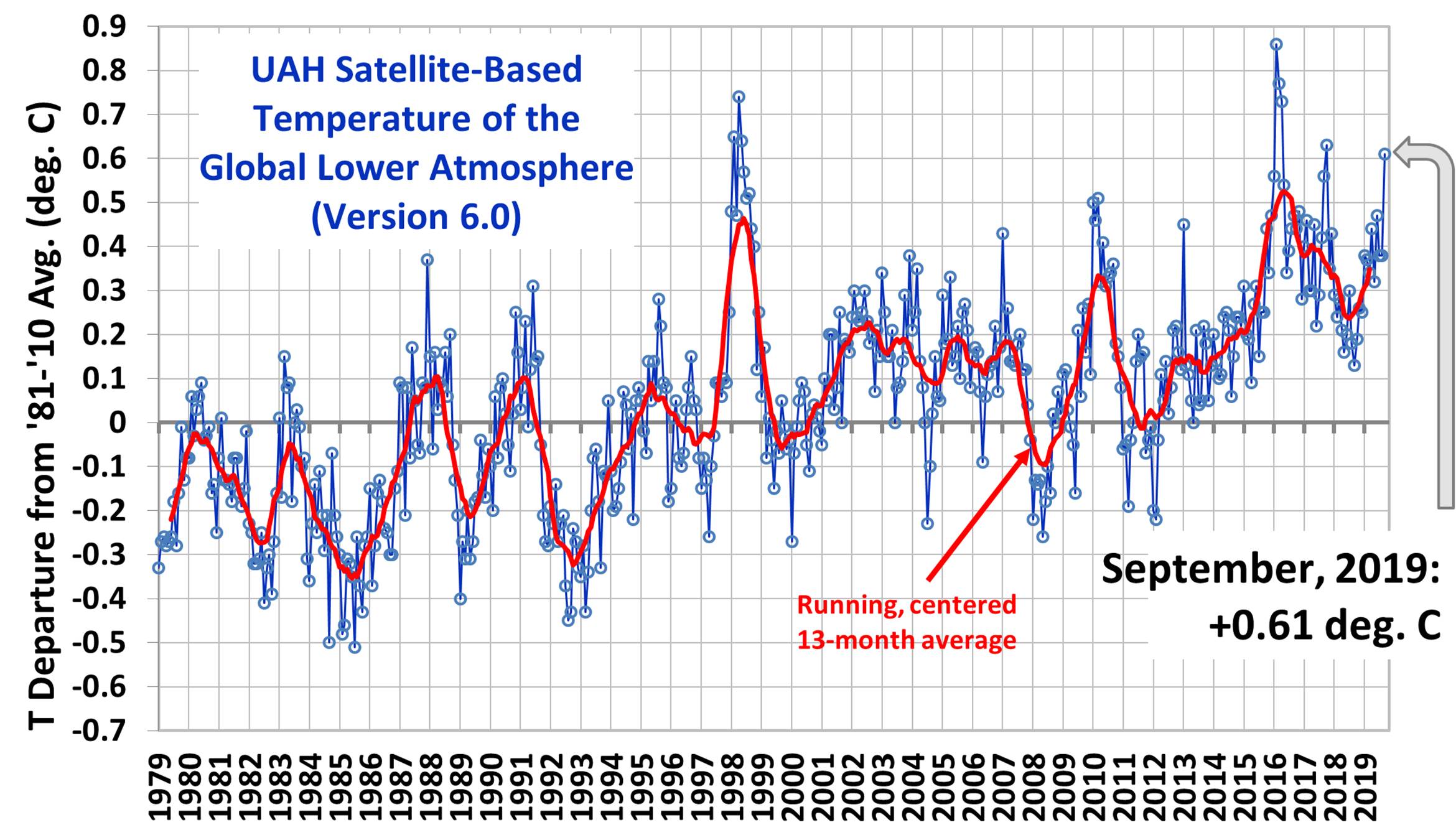
The linear warming trend since January, 1979 remains at +0.13 C/decade (+0.11 C/decade over the global-averaged oceans, and +0.18 C/decade over global-averaged land).
Various regional LT departures from the 30-year (1981-2010) average for the last 21 months are:
YEAR MO GLOBE NHEM. SHEM. TROPIC USA48 ARCTIC AUST
 2018 01 +0.29 +0.51 +0.06 -0.10 +0.70 +1.39 +0.52
 2018 02 +0.24 +0.28 +0.21 +0.05 +0.99 +1.22 +0.35
 2018 03 +0.28 +0.43 +0.12 +0.08 -0.19 -0.32 +0.76
 2018 04 +0.21 +0.32 +0.09 -0.14 +0.06 +1.02 +0.84
 2018 05 +0.16 +0.38 -0.05 +0.01 +1.90 +0.14 -0.24
 2018 06 +0.20 +0.33 +0.06 +0.11 +1.11 +0.76 -0.42
 2018 07 +0.30 +0.38 +0.22 +0.28 +0.41 +0.24 +1.48
 2018 08 +0.18 +0.21 +0.16 +0.11 +0.02 +0.11 +0.37
 2018 09 +0.13 +0.14 +0.13 +0.22 +0.89 +0.23 +0.27
 2018 10 +0.19 +0.27 +0.12 +0.30 +0.20 +1.08 +0.43
 2018 11 +0.26 +0.24 +0.27 +0.45 -1.16 +0.68 +0.55
 2018 12 +0.25 +0.35 +0.15 +0.30 +0.25 +0.69 +1.20
 2019 01 +0.38 +0.35 +0.41 +0.35 +0.53 -0.15 +1.15
 2019 02 +0.37 +0.47 +0.28 +0.43 -0.02 +1.04 +0.05
 2019 03 +0.34 +0.44 +0.25 +0.41 -0.55 +0.96 +0.58
 2019 04 +0.44 +0.38 +0.51 +0.53 +0.50 +0.92 +0.91
 2019 05 +0.32 +0.29 +0.35 +0.39 -0.61 +0.98 +0.38
 2019 06 +0.47 +0.42 +0.52 +0.64 -0.64 +0.90 +0.35
 2019 07 +0.38 +0.33 +0.44 +0.45 +0.11 +0.33 +0.87
 2019 08 +0.38 +0.38 +0.39 +0.42 +0.17 +0.44 +0.23
 2019 09 +0.61 +0.64 +0.58 +0.60 +1.21 +0.75 +0.57
This makes September, 2019 the warmest September in the 41 year satellite record.
The UAH LT global anomaly image for September, 2019 should be available in the next few days here.
The global and regional monthly anomalies for the various atmospheric layers we monitor should be available in the next few days at the following locations:
Lower Troposphere: http://vortex.nsstc.uah.edu/data/msu/v6.0/tlt/uahncdc_lt_6.0.txt
Mid-Troposphere: http://vortex.nsstc.uah.edu/data/msu/v6.0/tmt/uahncdc_mt_6.0.txt
Tropopause: http://vortex.nsstc.uah.edu/data/msu/v6.0/ttp/uahncdc_tp_6.0.txt
Lower Stratosphere: http://vortex.nsstc.uah.edu/data/msu/v6.0/tls/uahncdc_ls_6.0.txt


