Record Cold Upper Mesospheric Temperatures Suggest Another Good Noctilucent Cloud Viewing Season

May 31st, 2020 by Roy W. Spencer, Ph. D.

Noctilucent clouds (NLCs) are often visible in the extreme upper atmosphere (80-85 km altitude) well after sunset in the late spring and summer at high northern latitudes. They form from ice condensing on meteoric dust at extremely cold temperatures (below 150 Kelvin or -190 deg. F). The cold temperatures are due to adiabatic cooling from dynamic uplift combined with little ozone to absorb the sun’s ultraviolet radiation.

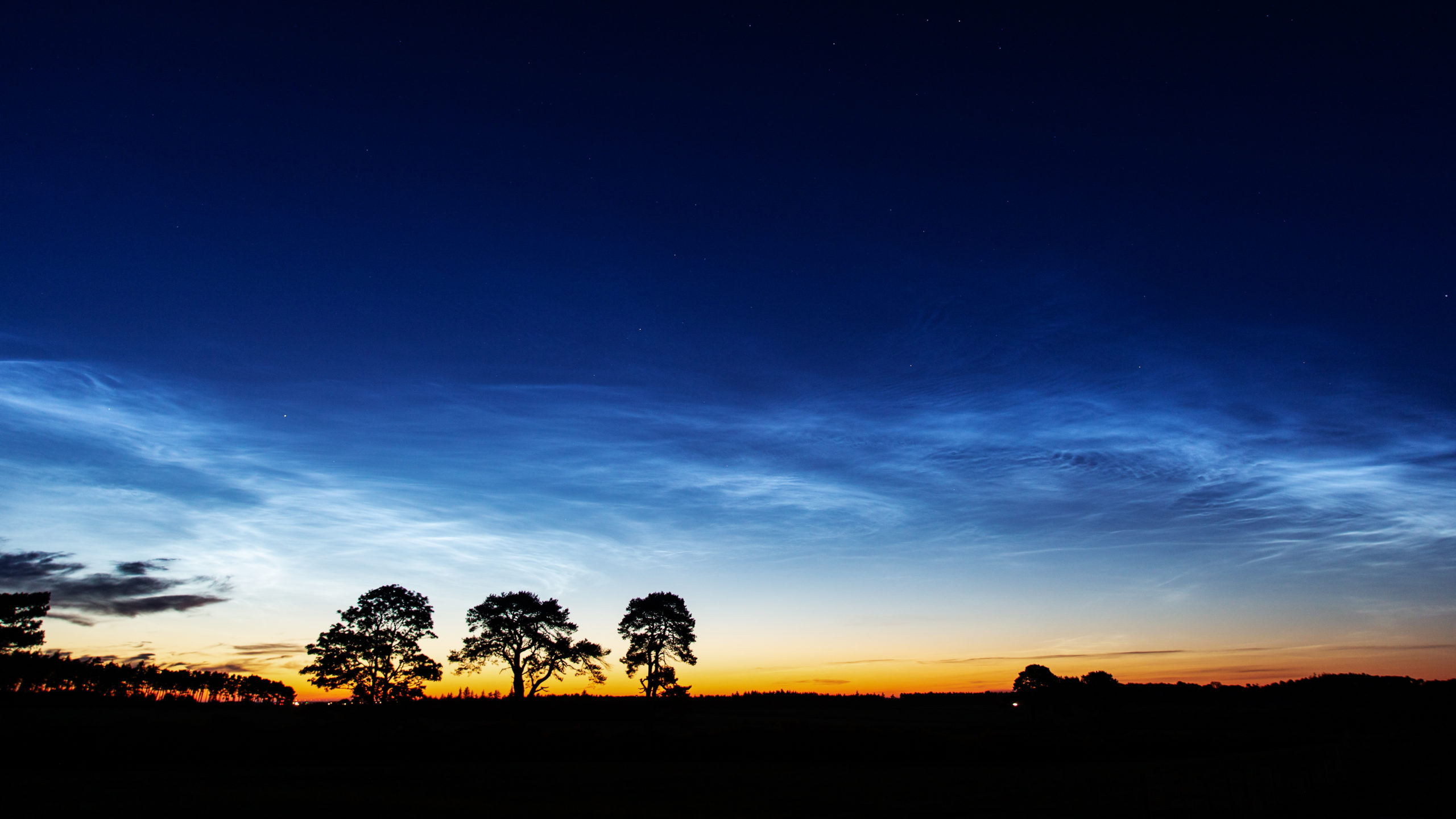
Noctilucent clouds on May 31, 2020 (Alan Tough, Scotland)

With current solar minimum conditions reducing solar heating by ultraviolet radiation, and slowly increasing CO2 in the atmosphere causing enhanced infrared cooling to outer space, record low temperature are occurring. This has extended the southernmost viewing opportunity for NLCs from the usual ~60 deg. N latitude to as low as 35N latitude last year, with NLC sightings near Los Angeles and Las Vegas in 2019.

This recent article by Dr. Tony Phillips suggested that 2020 is shaping up to be another good NLC viewing season. An earlier article by Tony included this nice plot of April-May temperatures at 80 N latitude from this year compared to previous years, showing the general cooling trend during the current solar minimum conditions.

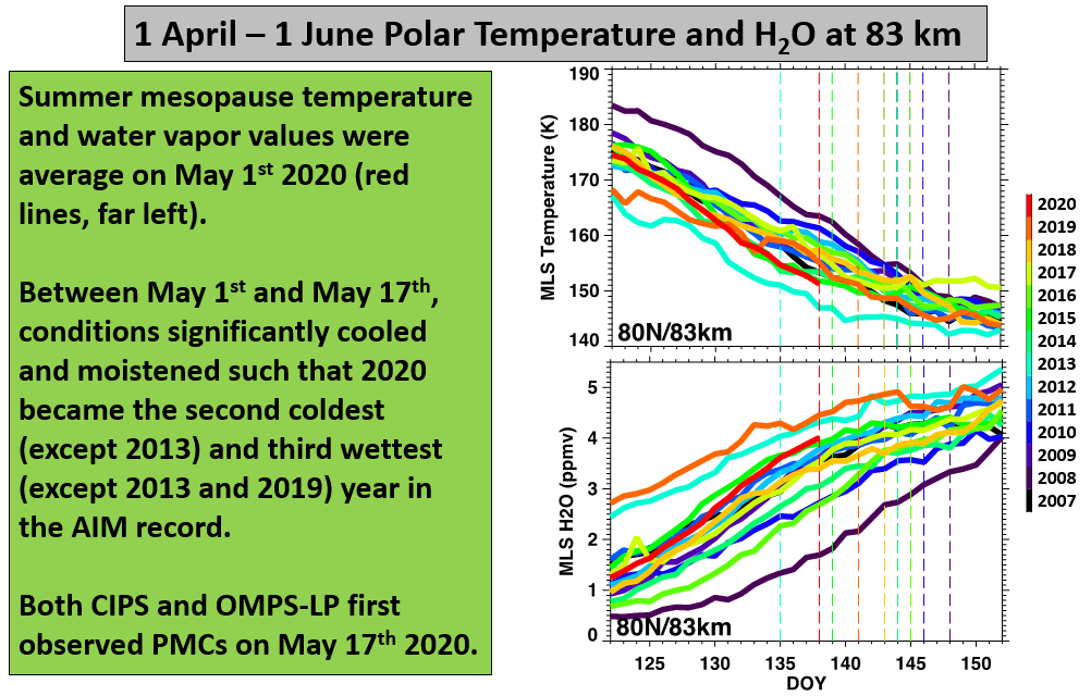
Data plot courtesy of Dr. Lynn Harvey, U. of Colorado.

We downloaded some more recent Aura satellite Microwave Limb Sounder data, and plotted it as a function of latitude. Note how fast temperatures dropped in only 6 days… 1-2 deg. C per day depending upon latitude.

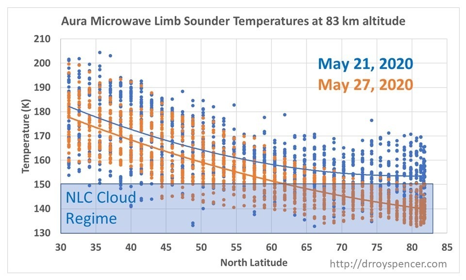
Upper mesospheric temperatures at 83 km altitude on two different days in May, 2020 as a function of latitude. Lines are 2nd order polynomial fits to the data, providing average temperatures as a function of latitude.

The 141 K average temperature on May 27 (Day 148) at 80N latitude appears to be a new record low if we compare it to the data in the previous plot by Dr. Harvey.

I will try to keep track of these temperatures as the NLC season progresses in the coming weeks. So far, NLC sightings have been mostly in northern Europe and the UK.


20 Responses to “Record Cold Upper Mesospheric Temperatures Suggest Another Good Noctilucent Cloud Viewing Season”

Toggle Trackbacks

  1. Charles says:

    Dear Dr Spencer

    I’d be very interested to hear your thoughts on the lockdown and its impact on weather / climate.

    Here in the UK since the lockdown we have had an exceptional run of crystal clear blue skies and dry weather. The BBC has confirmed it has been the sunniest Spring on record and the driest May on record, I believe.

    Both during the lockdown and the disruption to air traffic during the 2010 Icelandic volcanic eruption, I noticed the same ultra clear cloudless blue skies and a feeling of increased sun power.

    The lockdown may have had two key impacts across the whole northern hemisphere; (1) an unprecedented drop in air travel and hence a drop in contrails (2) a massive drop in emissions of all kinds of particles from transport and industrial activity which may have reduced cloud formation

    Is there any evidence of an effect from this on temps? Have day and night temps diverged unusually?

    • Chip Tasso says:

      Here in Chicago we had the wettest May on record.

      Out West there was record breaking heat on some days in May.

      C.T.

      • Charles says:

        I don’t know how concentrated aircraft contrails and industrial pollution are in that part of the US. Maybe the decline in those things wasn’t as severe there.

        Certainly a quick look at a map of the flight paths of aircraft across the world show a huge concentration over Europe, north east United States and Asia.

        So although Chicago is a very busy airport, the criss-crossing of flights seems much heavier in the north eastern part of the United States.

        Industrial pollution can also be surprisingly patchy. I know that northern Italy for example has really quite bad pollution.

        • Chip Tasso says:

          So by your logic, if there had been more flights over Chicago before the corona virus then we would have had clear weather instead of the rainiest May ever?

          I was just trying to point out that you can’t draw conclusions by looking out your window, or even considering the weather of a area 0.024 percent of the world. Illinois is roughly the same size as England, and is the 25th largest state in the US.

          • Charles says:

            Chip, I am not drawing conclusions, I am pointing out an observation which is valid. Given that we are talking about weather I would have thought that observations were rather important, wouldn’t you?

    • tim wells says:

      I remember a few years ago in the Uk where we were in the middle of a drought. It then went to the other extreme.

  2. ren says:

    The increase in geopotential height in the stratosphere over the polar circle is related to the escape of water vapor into the stratosphere.
    https://www.cpc.ncep.noaa.gov/products/stratosphere/strat-trop/gif_files/time_pres_HGT_ANOM_AMJ_NH_2020.png
    However, this does not mean that the temperature in the stratosphere increases.
    https://www.cpc.ncep.noaa.gov/products/stratosphere/strat-trop/gif_files/time_pres_TEMP_ANOM_AMJ_NH_2020.png

  3. Mark Wapples says:

    You mentioned less heating of the upper atmosphere from less UV.

    Is the same effect leading to less heating of the surface?

    Anecdotal evidence for Charles the heat in Yorkshire appears to be dissapearing as soon as the sun goes down. Very warm days much cooler nights.

    • Charles says:

      Hi Mark,

      Yes, that is, purely anecdotally, the feeling I get here too. More powerful more intense sun during the day but cooler at night.

      I await with interest any input from Roy.

      Many thanks

      • Carbon500 says:

        Hi Mark and Charles – I’ve found this book to be a fascinating historical account:
        https://www.amazon.co.uk/Weather-Britain-Robin-Stirling/dp/1900357062
        It’s entitled ‘The Weather of Britain’ by Robin Stirling. The first edition came out in 1982.
        In it, he refers to the hot and dry UK summer of 1976 – he comments: ‘the dry air allowed intense radiative cooling at night, particularly in the country. Ground frosts were even reported at a number of valley sites and at Kew.’

  4. CM says:

    This NL cloud pic was posted today on a Facebook page from British Columbia:
    https://www.facebook.com/109315035764459/posts/3482106121818650/?d=n

  5. ren says:

    A tropical storm will develop in the southeastern Gulf of Mexico.

  6. gbaikie says:

    Spotless Days
    Current Stretch: 30 days
    2020 total: 121 days (79%)
    2019 total: 281 days (77%)
    2018 total: 221 days (61%)
    2017 total: 104 days (28%)
    2016 total: 32 days (9%)

    https://www.spaceweather.com/
    Thermosphere Climate Index
    today: 2.93×10¹⁰ W Cold
    Max: 49.4×10¹⁰ W Hot (10/1957)
    Min: 2.05×10¹⁰ W Cold (02/2009)

    Do think add another 150+ days of spotless in
    2020?
    Or less than 50?

  7. Aaron S says:

    Are these clouds reflective to the incoming light spectrum?

  8. PhilJ says:

    This should result in an increase of infalling O and thus increase ozone production.
    I anticipate continued recovery in ozone layer levels.
    .

  9. HDBD says:

    Thanks a lot for the post.
    Your small article helps me to move forward with my research work.
    Please keep on posting this type of informative post.
    Let’s hope for the best.

  10. This is a good article. You’ve done great work!

  11. mario games says:

    I recall that the UK was experiencing a severe drought a few years ago. Then it took a turn for the worst.

Leave a Reply