40 deg. Temperature Drop for Deep South

March 4th, 2015 by Roy W. Spencer, Ph. D.

A strong cold front is forming today and will plunge through the Deep South, bringing a 40 deg. F temperature drop.

Here’s a time lapse video of hourly temperature forecasts from the WRF high resolution model, showing just how abrupt the temperature change will be as the front passes (original graphics from Weatherbell.com):

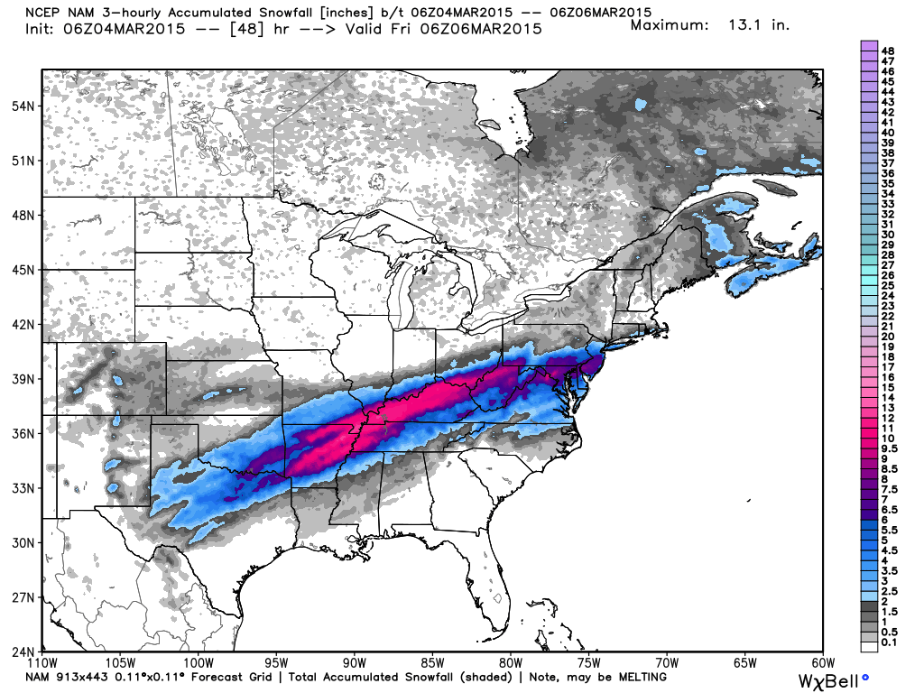
Winter storm warnings have been issued for northern portions of the South where up to a foot of snow is expected, mainly through the Ohio River Valley:

nam_3hr_snow_acc_east_17


5 Responses to “40 deg. Temperature Drop for Deep South”

Toggle Trackbacks

  1. Lewis says:

    What, weather again! Didn’t we have some yesterday?

    For an observer, and consumer of weather, it is almost, but not quite, amusing to see how weather has become a partisan issue.

    For those, like Dr. Spencer, who are directly involved in the arguments, I don’t expect it is amusing at all.

  2. Alick says:

    When you give your temperature update, is there any significance to what average baseline you choose to compare it to?

    Also on those updates, when you write +.25 degrees for a zone and then it is +.25 degrees the next month, doesn’t that mean there was “no change”? People like me see all the (+) signs and think, “boy, the earth is really been warming.”

    Since it is only a mile away, I like when you talk about Lake Superior.

    I’m learning from other websites just how hated you really are by the man-made CO2 induced global warming crowd. Keep up the good work.

  3. geran says:

    40 degree drop!

    Likely more new temp records.

  4. Slipstick says:

    Meanwhile, in other news, the start of the Iditarod Race has been moved due to snow accumulation in Alaska about 1/3 of normal, during a winter with an average temperature departure of +6 – +8 deg, depending on location. Also, ice fishing tournaments in Wyoming last month were cancelled because of dangerous ice conditions due to the unusually warm winter.

    While land surface temperatures over about 5% of the globe were below average over the last 30 days, about 20% of the globe was above average (via “eyeball integration” of the latest NCEP operational data global 30-day anomaly map).

Leave a Reply