Oroville Dam Emergency Spillway Repairs Starting

February 13th, 2017 by Roy W. Spencer, Ph. D.

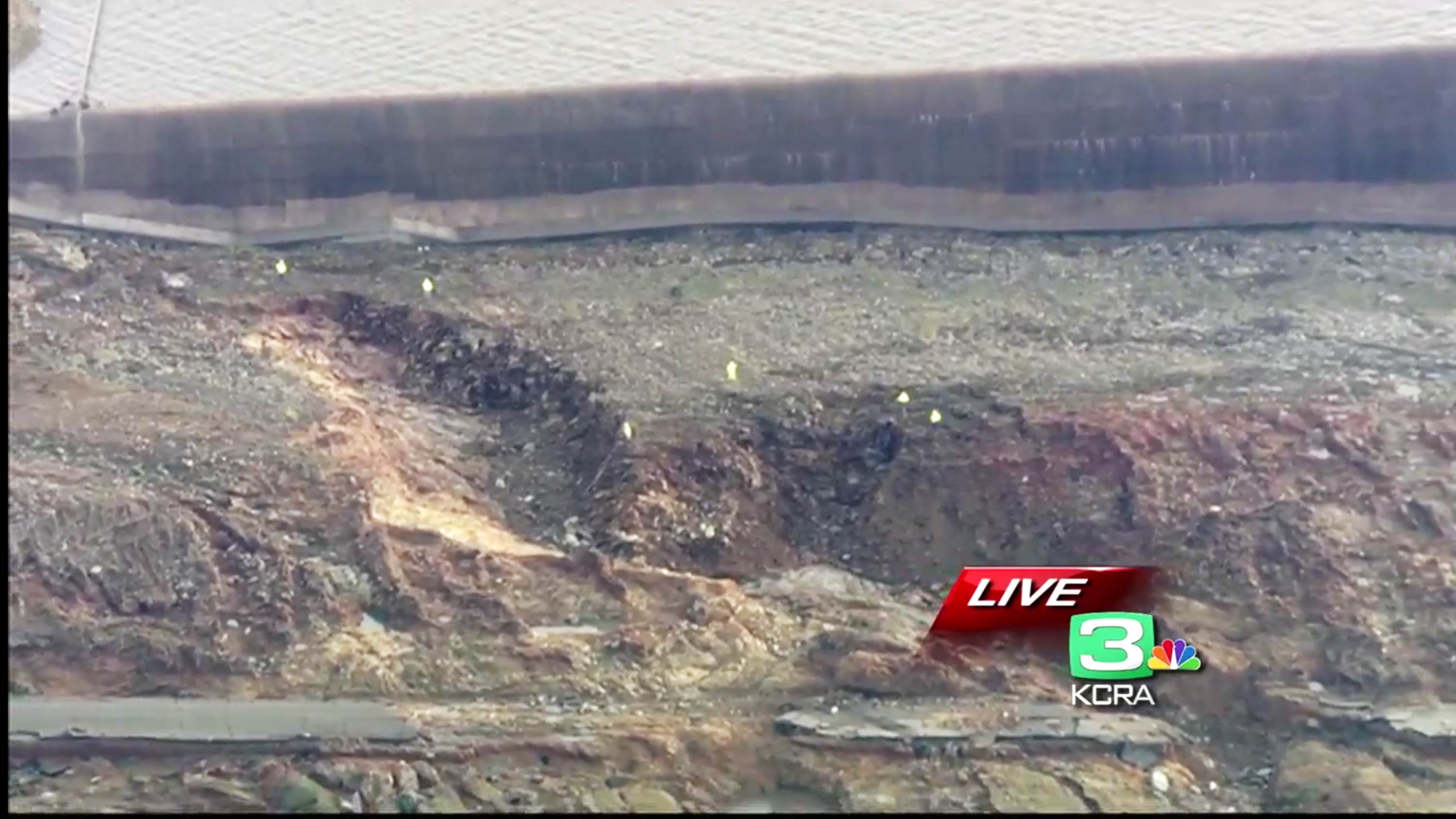
With daylight and Oroville Lake water levels now 4 feet below the lip of the emergency spillway, we can see that the area of concern is a gouge which developed near the far end of the concrete weir, and was eroding uphill toward that structure; for scale, those yellow spots are people inspecting the gouge (click images for full-size):

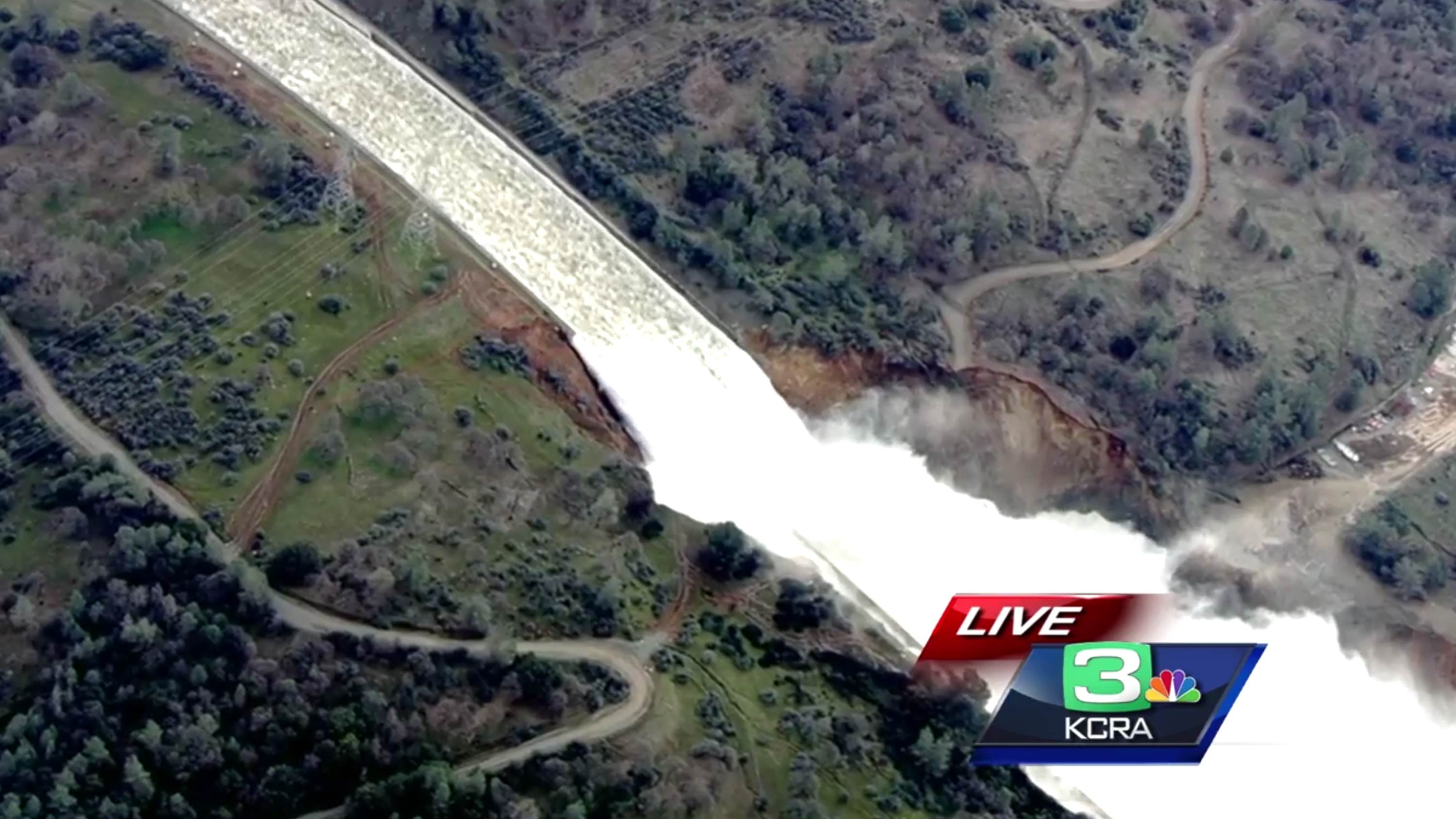
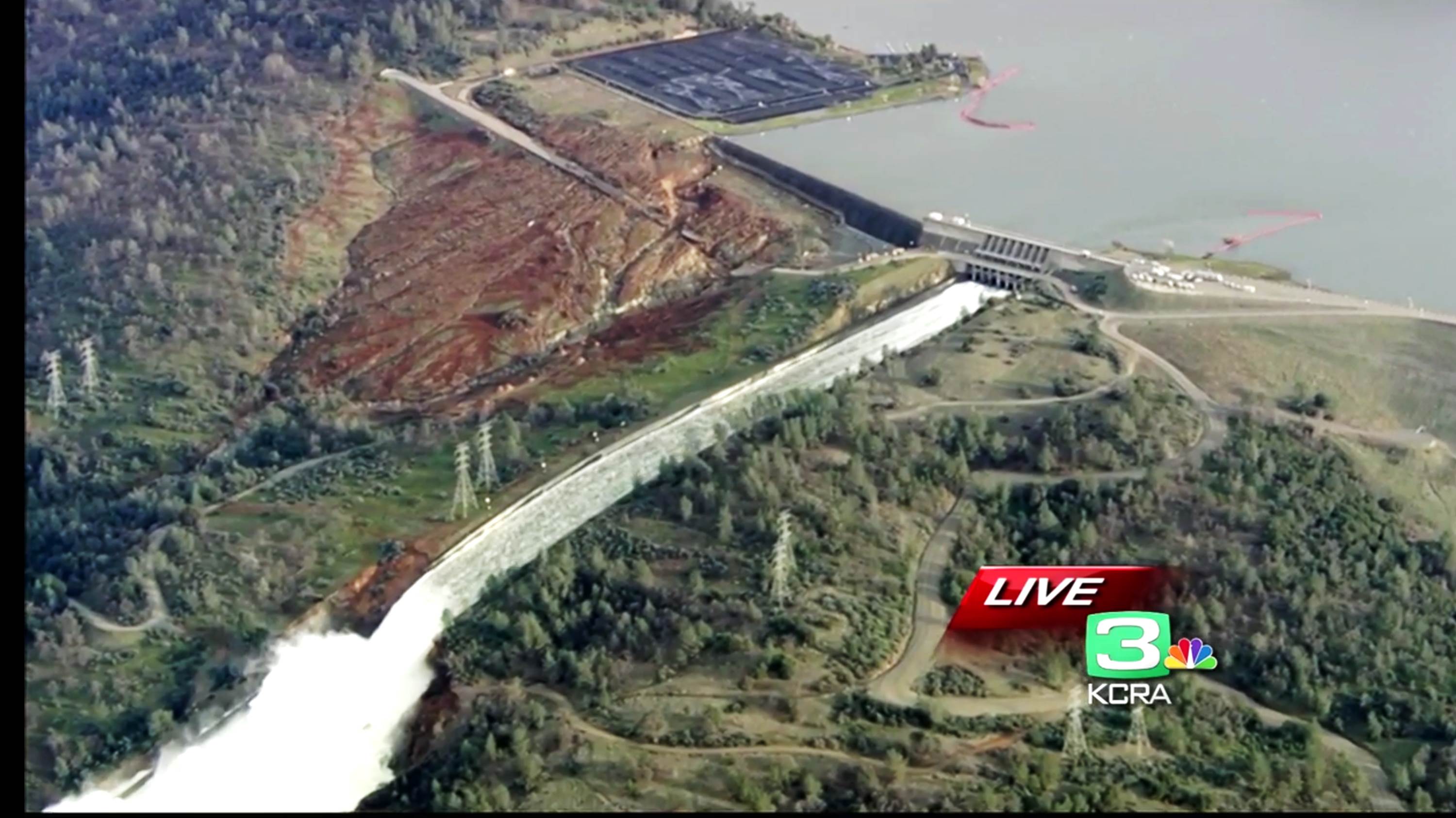
A wide-angle view (KCRA-TV helicopter frame grabs) shows the main, heavily damaged spillway which still has a huge 100,000 CFS flow continuing in an attempt to reduce the lake level as much as possible:

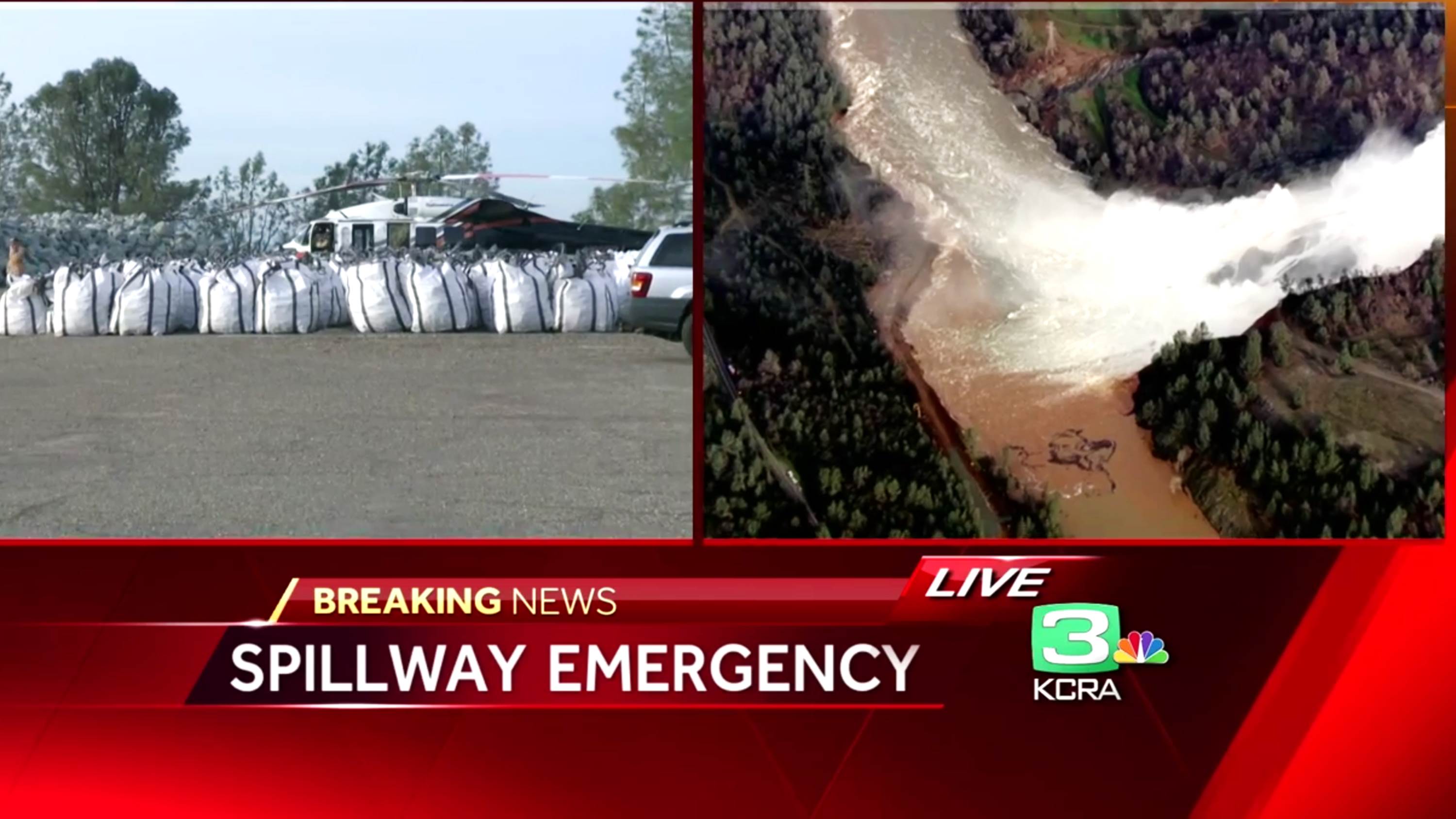
Rocks have been bagged overnight and helicopters will soon start filling the gouge:

The 100,000 CFS flow through the main spillway continues to erode the break in the concrete flume, but engineers are not worried about the damage eroding uphill and damaging the main portion of the dam:


43 Responses to “Oroville Dam Emergency Spillway Repairs Starting”

Toggle Trackbacks

  1. Beyond Concerned says:

    Thanks for sticking with this.

  2. Beyond Concerned says:

    As you can see the emergency spillway was built on the loose dirt of the hillside. Even if you pile rocks into the hole it won’t stop erosion from lower on the hill cutting back towards the spillway if they have to use it again.

    • Mike M. says:

      Beyond Concerned wrote: “As you can see the emergency spillway was built on the loose dirt of the hillside.”

      How can you see that? X-ray vision?

      It looks like along most of the area near the weir there is not a lot of erosion. Seems to me that must be solid rock. And the erosion in the area of concern slowed down greatly after a while, implying that it reached solid rock. So it seems logical to conclude that the engineers who built the dam were indeed competent and build the weir on solid rock.

      • If that was the case, why the emergency evacuation based upon concerns that the erosion would reach the concrete and compromise the base of it? I don’t have an answer…just trying to understand whether that concrete is on bedrock or a certain amount of fill over the bedrock.

        • Mike M. says:

          Roy,

          I think what happened is that they saw erosion working it way toward the weir in a way they did not expect. So they quite reasonably assumed the worst and ordered the evacuation. Then the erosion slowed.

          • Seems like it would be critical to have some sort of evidence, including photographic evidence, of just what the concrete was poured on when the dam was constructed. The emergency spillway is supposed to handle 350,000 CFS, and it took little more than 10,000 CFS for a little more than a day for this to happen. So, if you are correct, the formation of that gouge should not have been cause for any alarm at all.

        • Beyond Concerned says:

          Here is an engineer for dwr expaining why 20,000 cfs would be no problem for the emergency spillway:
          https://www.periscope.tv/w/1BRKjEbnpDdxw

          Right around the 11 minute mark.

      • Lester says:

        From some recent chopper video it looked like that to me also. Engineers and climbed down into the hole and the walls looked sheer and they did not seem muddy. The “canyon” walls where the dam is built look pretty steep.

        I still wish I could find a diagram as to the soil composition around there. There has to be engineering drawings.

      • Beyond Concerned says:

        https://twitter.com/TroyJBarnhart/status/831201627524575232?ref_src=twsrc%5Etfw

        That “bedrock” is not as solid as you think. You can see how the water eroded it in the above video. They were told that this was unsafe twelve years ago. You have to remember that in 1968 they were overconfident. Then in 1976 the Teton Dam in Idaho failed and they updated their standards. This Dam would not be built today. The hillside is not going to hold up. Don’t believe me? Youtube some hydraulic mining videos.

      • Beyond Concerned says:

        You can see how deep the holes are. They go down 30-40′. That is not bedrock and relatively low flows cut right through it.

    • dam1953 says:

      This is basically what happened w/ Katrina in NO. In some places, the storm surge topped the barriers, washing away the reinforcement on the backside. Once that support was gone the barriers folded over. In Oroville, it is my understanding that the emergency spillway is 100 ft tall, generating substantially more force than what NO experienced.

      • William Weirick says:

        Small correction. The worst issue with Katrina, as documented by a forensic investigation, is that the sheet pilings anchoring many of the flood walls were not driven to design depth. Sloppy oversight, or worse, among the contractors supervised by the Levee Boards. In many cases, the hydraulic pressure pushed underneath the too shallow sheet pilings and created boils on the protected sides of the flood walls. Overtopping was NOT the most serious problem, the fact that the flood control walls did not perform to design specs was the most serious. The storm surge NEVER exceeded design standards. Similar to the fact that the Oroville primary spillway failed at about 1/4 of maximum design flow and the secondary spillway failed the first and only time it was used in history. I am seeing far too many parallels between these documented bureaucratic failures by the Corps of Engineers and the Levee Boards in Orleans Parish and what we are seeing with DWR’s oversight of this critical infrastructure.

  3. Beyond Concerned says:

    It looks like the flat section at the base of the spillway has buckled and slid down from the spillway. How are they going to fix that in two days?

  4. Ric Werme says:

    They might be able to put “flashboards” at the weak part of the spillway crest to block nearly all of the water there. There’s lots more spillway that hasn’t eroded, so they won’t lose much capacity.

    They can also do something to seal off the parking area. What a mistake that is!

    • Matt says:

      That’s a good idea, Ric. If the crest of the spillway is wide enough, sandbags a couple feet high should be adequate to block off that end of the weir.

      Good blog, Dr Roy Spencer! As an engineer, I have been looking for better/more info than what’s in the news, and I’m happy to have found this.

    • Scott Gates says:

      Ric … the parking lot is part of the spillway … spreads the spillway to 1700 feet long instead of just 900 …

  5. Bart says:

    “…for scale, those yellow spots are people inspecting the gouge (click images for full-size)…”

    Thanks for that. At first, I looked and thought, that’s not so bad. Then, I read your note. Wow.

  6. Travis Casey says:

    I heard on the news several times that this is the tallest dam in the US. and it didn’t look or sound right. It turns out to be true, but I was deceived because the recent shots are mainly of the weir and emergency spillway, which don’t appear all that tall.

    https://upload.wikimedia.org/wikipedia/commons/d/d5/OrovilleDam.jpg

  7. ren says:

    February 15 jet stream will share over California and will bring a powerful downpour on the west coast.

  8. Myron Mesecke says:

    Let’s say that the lip of the emergency spillway was indeed constructed on bedrock. Constructed 50 years ago.
    Since then there was been 50 years of sun, rain, wind, etc.
    What has that weathering done to the exposed rock?

  9. Tim Wells says:

    Same thing happened to a smaller dam in the UK when we had heavy rain a number of years ago. In the end it was repaired and they got away with it. Search Ulley reservoir leak.

  10. Ross G says:

    My thoughts on this is that the USA has not built dams like this for 35 years. The dam design and construction engineers are gone. You now have dam maintenance and operations engineers trying to understand and resolve two serious design problems. It’s going to take them a while to figure this out and then further to execute the fix (aka dam construction engineering).

    I guess the emergency spillway was designed for a worse case scenario-design rainfall with the main spillway failed (closed). So the operation to date was way below design. It’s possible the erosion seen was envisioned and accounted for in the design 40 years ago. Perhaps no one today understands (or has confidence in) how it was supposed to work. I assume they have the original drawings they need.

  11. ren says:

    I asked why in California maintained a drought?
    https://youtu.be/JxbDJlruQ-4

  12. Beyond Concerned says:

    Only five hours of daylight left and the helicopters have not moved. The rains start on Thursday.

  13. Beyond Concerned says:

    More vague talk at the press conference today. They cut it short and did not answer any real questions directly. They all looked scared.

  14. Gerry Olsen says:

    Big gambles, but they sure have run out of options. The emergency spillway only works in total over-capacity mode, and its’ failure would catastropically release a huge amount of water. How about lowering the level using the damaged main spillway, before demolishing portions of the emergency spillway to establish a new and safer reservoir level?

    Any large catastrophic water release will cause much more damage, than a larger constant flow, I hope…

    Am just as worried about damage done by continued use of the main spillway. Hopefully they’ll have time and opportunity to build a second main spillway, and repair the original one.

  15. Pete Mack says:

    Came to make the same point as Gerry.
    There are only two questions that matter now.
    1. How long can the original spillway take heavy load.
    2. How to mitigate the eventual failure, if and when the spillway becomes to risky to use.

    The first thing is to reduce head in the dam for when the failure begins. A catastrophic failure would run away very quickly–basically starting well up the slope super linear damage curve. It’s desirable to start as far down that slope as possible. So it may be better to dynamite the emergency spillway and just grade it as level and low as possible. Then there’s less water, and, more critically, less head for any possible blowout: start as far down the failure curve as possible.

    I can’t see any other way to get a little ahead of the problem. All they are doing is reactive.

    Bags of rocks with helicopters–helicopters!– just cannot address the magnitude of the issue.

    They have a little time for action, and that time is golden. Worst case planning just has to be on the agenda.

    • Scott Gates says:

      They have continued to run the main spillway at 100,000 cfs since Sunday afternoon … wtaer levels were 901.58 at appx 17:00 PST Sun … at 22:00 PST 2/13 they are 892.41 … draining appx 1′ per 4 hours.

      No additional significant damage to main spillway despite 100,000 cfs flow for appx 30 hours

      Their goal is 50′ drop – to 851 feet

      You also have to consider the majority of rain doesn’t hit the reservoir for some time – as it makes its way thru tributaries.

      http://cdec.water.ca.gov/cgi-progs/queryF?s=ORO&d=13-Feb-2017+22:31&span=36hours

  16. Ken McDonald says:

    Dr. Spencer,

    This is probably a stupid idea.

    Place 100 12inch diameter SYPHON pipes over the emergency spillway and have them drain into flexible pipes run down to the river. No erosion. Move a heck of a lot of water out of the lake. It would take pressure off the damaged main release gate so they could back it down some.

    Ken McDonald

  17. Keith says:

    Hindsight being 20/20, while I shared your concern that COULD happen, you declared it WILL happen — and it didn’t. Speaking of erosion, that’s your credibility that just took a cut. Be concerned. Express your thoughts. Just stay out of the prediction business.

Leave a Reply