I’ve had a little criticism here and on Facebook that I’m not a geologist, so I shouldn’t be second-guessing the Oroville Dam engineers. They called for evacuations last evening out of an abundance of caution. That the emergency spillway is no doubt built on bedrock, and so it is safe.
Well, if it was only out of an abundance of caution that evacuations were ordered, why did emergency officials claim that there might be only one hour until the concrete weir topping the emergency spillway would fail? Hmmm?
And take a look at one of the ravines that eroded from only a little over 24 hours of flow over the emergency spillway

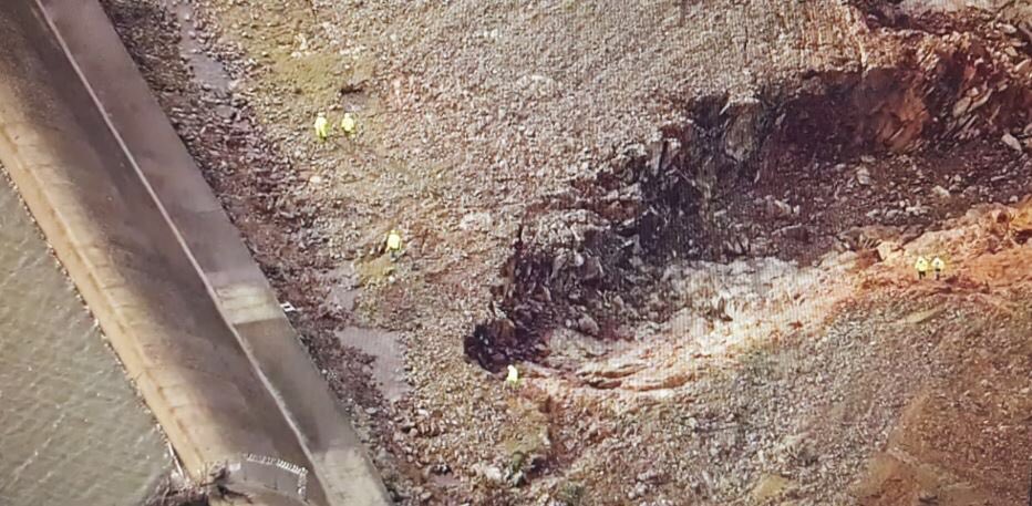
One of two major eroded areas just below the emergency spillway of Oroville Dam (Feb. 13, 2017). The little yellow spots are people.
Does that erosion feature look like it’s cutting into bedrock? Even though the spillway is supposed to handle 250-350,000 CFS, it was only ~10,000 CFS total flow across the 1,700 ft. long weir that caused this.
The latest press conference held shortly after noon today suggested that officials are avoiding hard questions. At one point a reporter asked, “With two parts of the system compromised (the main spillway and emergency spillway), how secure can people be?“. The speaker was not allowed to answer the question.
I honestly don’t know what’s going on, but if I lived in the flood plain (and now one of the near-200,000 people evacuated), I’d be wanting some more definitive information.
I hope the bottom is ebedded in bedrock. Looks like the power towers are seeing encroachment from the main spillway flow erosion in the other pics you have of that area. What a mess no matter. Californication once again…..
That might well be, and I hope so. But if that’s the case, why were (are) they worried? It seems like there would be photographic evidence during construction so later generations could see what the hell this thing was built on.
Why don’t the engineers just say, “Listen, the concrete weir was built on solid bedrock, there’s nothing to fear. People can go back home”?
That’s not happening. Why?
Why? Because it is not built on solid bedrock. As you pointed out with this article you can see how weak the soil is with your own eyes. The bottom line is that this dam is in serious trouble.
Found this item.
https://www.youtube.com/watch?v=p_5udzKfLQM
I wouldn’t be surprised if the weir is sighted on the old roadbed for that service track they used to bring the dam material in on.
Yeah, back from the dam, there’s what passes for bedrock in that part of the world. It’s badly fractured, and didn’t stand up to even a modest flow, but it looks like pieced together bedrock, not fill. Darn good thing this got tested by a semi-planned release and not an dam overstepping due to flooding beyond capacity of the main spillway.
The slow failure from back erosion of the main spillway–and any further undermining of the actual dam’s hillside foundation–are the critical paths now. No way they can use the emergency spillway except as a last resort when choosing a go-to-hell failure mode.
Interesting input, thanks.
The only people who don’t currently have egg on their faces are the sheriff who pulled the trigger in the evac last night, and the consortium of environmental groups who called for paving the emergency spillway during the 2005 relicensing. FERC and Cali since that time have both been negligent. BTW: I’d never think I’d use the phrase ‘environmental groups call for paving’. Talk about I told you so, but any Sierra Club members can feel that way, UST a little bit.
I’m interested in what was happening where the weir ends in the bedrock, the the latest photo seems to show something unusual there, it’s right at the bottom of the photo from today. Also when I look at the photo from yesterday it looks to me like there is a stream of water pouring over the weir right where it is socketed into the bedrock at the end farthest from the dam.
If that is bedrock (think not, as an avid amateur rockhound for over 40 years) it is so rotten than it is useless from a weir anchoring perspective. As we now know from the evacuation order. Useful bedrock does NOT erode rapidly.
There is no choice about using or not using the emergency spillway. If the damaged main spillway (which is controlled by 7 30 foot gates) is unable to keep the lake below 901 feet, it simply starts spilling over the emergency weir all by itself. That is the design. Same as my farm pond, which is one acre and still has an emergency spillway backing up the main spillway (a 10 vertical 3foot diameter corrigated steel pipe joining a 3foot diameter steel pipe the runs through the dam, protrudes about ten feet beyond and spills into a riprapped section of the old washbed. Has been used a couple of times when deep snow and heavy spring rains coincide and the catchment overflows.
The erosion from less than 24 hours of about 1 foot overtopping shows that the weir is not sitting on meaningful bedrock from an engineering safety perspective. Whether it has deep footings dunno, but somebody does because the building plans haven’t disappeared. The evacuation order suggests no. And once the erosion undercuts the weir, it will topple forward downhill from the water pressure behind it. That is the feared catastrophic release. The attempt to backfill the erosion gully with rock will simply move the erosion to next weakest spot along that 1700 foot weir. This is a real dangerous situation from now until spring snowmelt is past
Yes, there was a conscious decision to use the emergency spillway when flow to the main spillway was cut to 55kcfs and then 35kcfs. The chart for the current fill of the dam blows up suddenly when the spillway was partially closed, and overstepped the emergency spillway within 48 hours. Now the main spillway is dumping 100kcfs, and the level is going back to it’s usual level of 80-85% capacity for this time of year.
http://cdec.water.ca.gov/cdecapp/resapp/resDetailOrig.action?resid=ORO
Understand your point.
Another blogger noticed several days ago that the hole in the main spillway showed no rebar in the concrete. Normally you would expect to see dangling rebar ends sticking out of a hole like that.
Yes there is rebar. No you can’t see it at the scale of these pictures. You can barely make out PEOPLE in the image above.
Yeah, Anthony Watts may have gotten a little too excited there, and walked it back later. I was able to make out the curling ends of the snapped rebar by blowing up the picture. It looked like there was precious little of it – I was expecting more. But, I am in no way qualified to make a judgment on such matters.
Observing the growth rate of the water level should be from mid-December to systematically increase the outflow (compared to the years 1977-1978).
http://cdec.water.ca.gov/cdecapp/resapp/getResGraphOiginal.action?resid=ORO&waterYears=1976&waterYears=1982&waterYears=2016&waterYears=1977
The more that was known about heavy snowfalls in the mountains.
First video I’ve seen of the erosion shown above. Yeesh.
http://www.kcra.com/article/first-view-of-erosion-at-oroville-emergency-spillway/8756049
Latest news is that there is no known timeline to rescind the evacuation order. Our church (among many others) here in Chico is being used as an evac center, and we’ve made up makeshift sleeping arrangements in case they’re needed (we expected to bunk 2 DWR workers last night, but didn’t need to).
It’s pretty tense here.
From Thursday will begin a very heavy rain. You have to wait.
Hang in there, Mark. If there’s one thing I know from growing up in the Midwest, there’s nothing like natural disasters to erase any political differences between people or the ideologies they ascribe to. The people of Chico and Oroville and other nearby communities are good people; I’d like to see the braggarts in San Francisco, Berkeley, Sacramento, and L.A. get humbled a little, just so that they can understand their sh-t doesn’t NOT stink.
Now we can only beg for mercy Mother Nature.
Look at any of the recent videos of the main spillway and you can see the water change direction as it goes over the lip of the damaged section. With full flow continuing it is hard to be sure, but the hole now seems to cover the full width of the spillway and water is leaking under the retaining walls on both sides. Official announcements notwithstanding, the damage is getting worse
Looks as though the management have chosen to sacrifice the main spillway to keep pressure off the emergency spillway.
This is.
What they really have to monitor is main spillway back erosion. The main spillway rests on alluvium, as can be seen from the erosion below the collapse in the main spillway to its right as you face it. Water tumbling off the spillway break ‘cliff’ splashes in all directions, including uphill: back erosion. Niagara falls goes over solid rock, yet has still backeroded ~1-1.5 meters per year. The rock at the bottom of Niagara falls is shale. A lot sturdier than alluvium. And Niagara flow is ~85,000 cfd. Less than the current 100,000 cfs Oroville main spillway discharge. Doesn’t look good in the long run.
Sounds like this might be another case of experts destroying their credibility by treating the public like children. When they think there is no need to evacuate, they downplay concerns so as not to panic the children, er, public. Then when they decide that evacuation would be prudent, they play up the danger (failure of the weir is imminent!) to make sure people do as they are told. Then, when disaster does not happen they … Well, it doesn’t much matter since people have stopped believing them.
Not quite. You can see that the erosion was severe and that the weir was about to fail. That is reality, not PR.
Mike M.
You can believe me or not, but after the upcoming rains will be flooding in California. The more that the majority of reservoirs are overcrowded.
http://cdec.water.ca.gov/cdecapp/resapp/getResGraphsMain.action
http://cdec.water.ca.gov/cdecapp/resapp/getResGraphOiginal.action?resid=DNP&waterYears=1976&waterYears=1977&waterYears=1982&waterYears=2016
Just looking at recent photos, it is startling how quickly the main spillway is eroding under the 100k cf flow…just saw a picture indicating that the concrete is now gone up to the top of the steeper bottom section of the slope (where the powerlines cross). This would indicate that they’ve lost at least another 100-200 feet of the spillway uphill since they began releasing again down the main spillway. At this rate, the flow could be threatening to undermine the main spillway gates with 36-48 hours. I think they will be forced to shut the main spillway gates again within a day. This crisis is far from over.
What will they do when the rain starts on Thursday?
That’s kind of the beauty of it … they won’t do anything, because there’s nothing that CAN be done. We’ve been deluded by the AGW crowd into thinking that mankind is responsible for all things weather and climate, and that we must pay penance for modern conveniences and the ICE. Mother Nature is going to do what Mother Nature wants to do, period. We sit back and wait until she’s done to shore up the leftovers and soldier on with creating a new life.
They will have to play a guessing game between letting water destroy the main spillway or letting it eat away at the hill beneath the emergency spillway.
Its a Crap shoot.. I’m surprised the main spillway has held up..
we shall see.
Yep. While not a house of cards the “bedrock” seems to be very prone to undercutting. Hope everyone (and the dam) make it through the spring OK.
It will be interesting to see how they lay down the rock on the bare hillside. I dont want to be the dude saying trust me it will work..
See my comment above on Niagara Falls. The uphill erosion caused by the main spillway failure is, in my opinion, a huge issue. And not resolvable until after snowmelt is done for the season.
It’s bedrock under the talus and soil.
The gash looks a bit like column basalt. Central Washington is covered with it. Historical floods (Missoula) rapidly washed this material way by peeling it off of the downhill side. See Dry Falls in Washington.
I note that the power line support tower adjacent to the main spillway was still in place as of the most recent photo I have seen. That is not far above where the hole initially developed. The uphill erosion does not appear to be rapidly back towards the dam beyond that point in the last couple days. I assume there is something hard under the channel there.
It appears the upper part of the channel is cut into bedrock. This is to be expected – the Feather River, before it was dammed, eroded the bedrock creating a valley. I am not a dam engineer (although I am a professional structural engineer with experience in river hydrology and soil mechanics), but it seems logical that the overflow channels would typically be cut into the rock as evident in the pictures of the upper section of the main overflow. HOWEVER, the rock in the area appears to be heavily fractured and weathered. It has further been twisted and folded by plate tectonics (fault lines). It looks to be quite variable – Roy’s picture could be a loose pocket in the ‘bedrock’ beneath the emergency overflow. I don’t know for sure. Pete Mack appears to be knowledgeable of the area – I am not – so I defer to him.
This is the reason officials cannot state things are safe. There are many unknowns in the geology here. If it were a gorge carved from solid granite, or even limestone, engineers might be able to make unequivocal statements as to safety. But here, they cannot. It is a very difficult situation.
It is easy to sit back an criticize (I am guilty) but imagine yourself in a decision maker’s shoes for a moment, in the heat of a very fluid situation (no pun intended). They are making decisions under heavy uncertainty. This shit is very real! We can gripe about what government authorities should have, or should not have done, but hey, most of us aren’t on the hotseat.
Exactly!
Well said.
Geology info at this link..
Also the hole is at the other end…
hmm
https://www.metabunk.org/oroville-dam-spillway-failure.t8381/page-6
Phenomenal link. Great find.
My only ‘local knowledge’ is from frequent hikes in the Sierra 15 years ago. A lot of the rock is schist or a relative to it. And it’s highly stressed and fractured from mountain formation, often meaning dangerous talus overburden. Schist doesn’t rhyme sound like ‘shut’ for no reason.
My current question is whether there’s a pool forming at the base of the waterfall. If so, that will reduce the erosion substantially, by breaking the force of the falling water.
The erosion was worse at the other end towards the dam structure that they are filling with rock .. a section of the flat concrete lip has collapsed being undermined .. the erosion had worked it’s way up to the emergency spillway as you had thought in the image you posted with the descriptions earlier .. this was definitely the main area of concern .. not the hole at the far side of the spillway away from the dam structure
In 1992, Belton Lake (Belton, TX) went over its emergency spillway for the first time. The lake was created in the 1950s.
At Belton lake the emergency spillway begins at a limestone bank. The emergency spillway is basically cut out of the limestone. There are several hundred feet of flat limestone the water has to travel before there is any real drop in elevation.
But once that water started downhill it was awe inspiring to watch the power of it. Water went over the emergency spillway for at least 2 weeks. Afterward they made the area below the spillway a series of nature paths.
Kind of glad we have that long flat shelf and no wall that can get undercut from erosion like Oroville.
If you look at the controlled spillway at the link you can see how small it is. Of course in central Texas it doesn’t have to be much bigger.
https://www.google.com/maps/@31.1096171,-97.4687834,1713m/data=!3m1!1e3
Here’s a great picture from the forum posted above of the bedrock behind the emergency spillway.
https://www.metabunk.org/attachments/20170213-224719-sp4sd-jpg.24569
So, yes it’s on bedrock. No it’s not eroding very quickly past the overburden. Yes, the engineers are doing a good job, letting the water do necessary excavations, and filling in any bad holes with rock and concrete. So we–I include myself–have been panicking a little prematurely. Alternating between the two spillway looks feasible at this point, which will allow any desperate temporary repairs to be done. I’d say after the first storm pass through this week, the evacuation should be over.
It will be a lot of rain in California.
http://pics.tinypic.pl/i/00870/ctunvf9u5sch.png
Emergency spillway is wide to cope with the flooding.
But the way down to the river can bee much less wide. And can bee dug out in bedrock.
Sorry.
If someone thinks that the temperature in the stratosphere over the polar circle in the winter does not affect the temperature of the troposphere and the jetstream is wrong.
http://www.cpc.ncep.noaa.gov/products/stratosphere/strat-trop/gif_files/time_pres_TEMP_MEAN_JFM_NH_2017.png
http://ocean.dmi.dk/arctic/plots/meanTarchive/meanT_2017.png
It looks like layered sedimentary rock formation to me so in my opinion it fits the definition of “bedrock” as presented e.g. on Wikipedia. But I’m not an american so I might be missing on language nuances. And it certainly had to be weathered and fragile to let the water erode it that much.
I’m really, really happy the dam did not break. And I hope they will succeed keeping it together until there’s chance to start with repairs. Pity they missed on the opportunity past years when the dam was mostly empty, I would guess they believed the 97% of scientists who agreed that the California drought is permanent?
The consensus has no effect on solar cycles and climate. Sun’s magnetic field changes during long periods.
http://wso.stanford.edu/gifs/Polar.gif
Roy et al. You are missing the point. Global warming weakened that bedrock.
AaronS et al. You are missing the point. Arm-chair experts are invariably wrong.
I wonder how comes so many people on internet lost their sense of irony.
It is because the irony, or more properly sarcasm, has become difficult to separate from sincere expression of thoughts. There is nothing so absurd that it hasn’t been ascribed to Global Warming by now. It might help in the future to include a “/sarc” tag, AaronS.
Thanks. I was indeed trying to make a joke.
For those interested in placing blame, look at the agendas of the CA water board’s annual meeting going back to 2008–the last four years into Schwarzenegger’s administration. The meetings cover every possible lightweight topic except engineering, infrastructure safety, and maintenance. The whole board should resign, effective immediately.
If the dam goes, so should the governor.
Forgot the link.
http://www.swrcb.ca.gov/board_reference/index.shtml
Thanks Dr Roy, for providing regular, reasoned updates with intelligent comments. A refreshing change from the sensationalism of the MSM, especially the UK Daily Mail – http://www.dailymail.co.uk/news/article-4221808/Officials-warned-Oroville-Dam-12-years-ago.html
I laughed out loud at that. There is nothing CO2 can’t do.