When a tropical cyclone moves poleward and merges with a frontal system, and then draws upon the extra energy that exists between cold and warm air masses, a Sandy-type storm can result.
Sometimes it causes explosive cyclogenesis, what we call a “bomb”, with rapidly deepening low surface pressures.
I’ve been watching Super Typhoon Nuri in the West Pacific, one of the strongest of the year, and each run of the GFS model continues to show this system becoming a spectacular extratropical storm in the Bering Sea, with hurricane force winds and near record low barometric pressure in about 5 days time, after it just misses Japan.
As of today, this is what Nuri looks like in the latest MODIS imagery…it’s not a particularly large storm, but it has an intense core, with maximum surface winds estimated at 180 mph with gusts to 220 mph (these are satellite-estimated…they do not routinely fly into typhoons to measure them like we do in the West Atlantic):
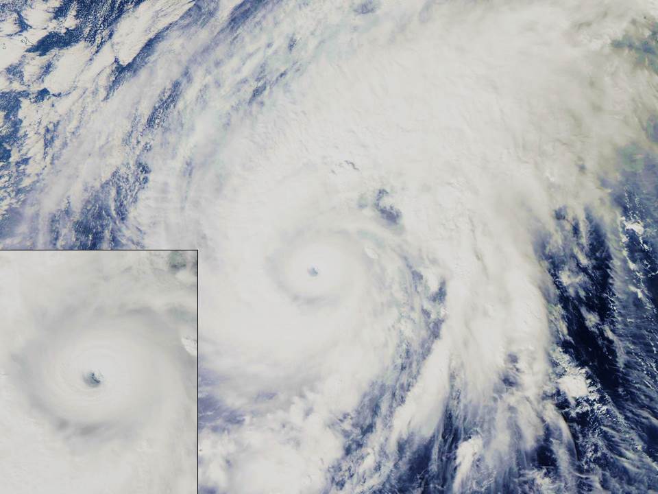
Here’s some nice video of Nuri from the International Space Station from yesterday:
The GFS forecast model run from this morning shows Nuri as an extratropical low with an exceedingly low central pressure of 924 mb (27.29 inches) by Friday evening (graphic courtesy of Weatherbell.com, click image for full-size):
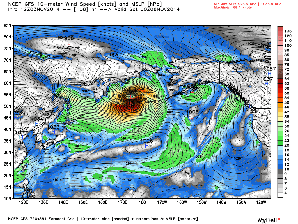
The previous 2 model runs had the low at 919 mb lowest pressure. By comparison, the lowest pressures recorded in extratropical storms have been in the range of 912-920 mb, in the North Atlantic, so it looks like Nuri might be one of the strongest on record. The lowest surface pressure ever recorded in the U.S. was from one of these Bering Sea systems: 927 mb (27.35 inches) at Dutch Harbor, Alaska on October 25, 1977.
Where, how could it affect the North America land mass?
. . wow, those ‘Deadliest Catch’ crab fisherman better keep their eyes on this . .! 🙂
Well I give you credit for being consistent on these “Hurricanes/Typhoons”.
Yet again the Stallites are showing wind speeds in MPH where they appear to be closer to KPH at ground level.
They were wrong on the last 2 so what odds are you giving for them being right this time?
they are not not my estimates.
Oh my God, I have a friend who lives on one of those Alaska tongues jutting into the Bering Sea. He and his wife teach school to Inuit, and they live in a house on stilts. I wonder what’s going to happen to them. Surely, they’re being moved.
The latest Canadian Global model has a pressure of 945 mb Saturday morning (12Z). We have found over the past few years the GFS model to be very unreliable over northern Canada, to the point we don’t even use it anymore. But, who knows, this time it may work out.
we shall see.
Dr. Spencer
Would it be worthwhile to estimate the amount of thermal energy being removed by such a storm?
Spent a year at Shemya (close to the end of the Aleutian chain), temperature doesn’t vary much between seasons but the wind sure does blow. Was driving back from the Tower in a 4×4 pickup and had the wind put me up on 2 wheels, scared the dickens out of me thought I was a gonner. But just as quickly the vehicle settled on all 4’s and then I could aim my rear at the wind for smooth sailing.
Nullschool shows 921 mb on 11/08/2014.
http://earth.nullschool.net/#2014/11/08/0600Z/wind/isobaric/1000hPa/overlay=mean_sea_level_pressure/orthographic=-171.14,71.35,481
Dr. Roy Spencer, the Low-pressure area over the Bering Strait bring very cold air into the north central states. As I moved the polar vortex will be allow any arctic air to America over the Bering Strait. The location of the stratospheric polar vortex is similar to the previous year.
Do not such storms that track this far north break up arctic sea ice resulting in a lower extent?
If you look at SWARM detected by changes in the Earth’s magnetic field, can be seen to be associated with anomalies of weather in the winter. Very cold in North America and a warm in Europe and northeastern Asia.
http://www.esa.int/var/esa/storage/images/esa_multimedia/images/2014/06/magnetic_field_changes/14582173-1-eng-GB/Magnetic_field_changes_node_full_image_2.jpg
Let’s see what happens in the stratosphere at an altitude of about 35 km.
http://www.cpc.ncep.noaa.gov/products/stratosphere/strat_a_f/gif_files/gfs_t05_nh_f00.gif
Dr. Roy Spencer frost, which will fall on a Sunday far southeast US, will mean the beginning of winter in the US?
Can anyone comment on the statement in the media and TV Meteorologists that Nuri amplified the wave and caused more cold air to flow southward into the lower 48. Where did this originate??