Home/Blog
NOTE: See the update from John Christy below, addressing the use of RATPAC radiosonde data.
This post has two related parts. The first has to do with the recently published study of AIRS satellite-based surface skin temperature trends. The second is our response to a rather nasty Twitter comment maligning our UAH global temperature dataset that was a response to that study.
The AIRS Study
NASA’s Atmospheric InfraRed Sounder (AIRS) has thousands of infrared channels and has provided a large quantity of new remote sensing information since the launch of the Aqua satellite in early 2002. AIRS has even demonstrated how increasing CO2 in the last 15+ years has reduced the infrared cooling to outer space at the wavelengths impacted by CO2 emission and absorption, the first observational evidence I am aware of that increasing CO2 can alter — however minimally — the global energy budget.
The challenge for AIRS as a global warming monitoring instrument is that it is cloud-limited, a problem that worsens as one gets closer to the surface of the Earth. It can only measure surface skin temperatures when there are essentially no clouds present. The skin temperature is still “retrieved” in partly- (and even mostly-) cloudy conditions from other channels higher up in the atmosphere, and with “cloud clearing” algorithms, but these exotic numerical exercises can never get around the fact that the surface skin temperature can only be observed with satellite infrared measurements when no clouds are present.
Then there is the additional problem of comparing surface skin temperatures to traditional 2 meter air temperatures, especially over land. There will be large biases at the 1:30 a.m./p.m. observation times of AIRS. But I would think that climate trends in skin temperature should be reasonably close to trends in air temperature, so this is not a serious concern with me (although Roger Pielke, Sr. disagrees with me on this).
The new paper by Susskind et al. describes a 15-year dataset of global surface skin temperatures from the AIRS instrument on NASA’s Aqua satellite. ScienceDaily proclaimed that the study “verified global warming trends“, even though the period addressed (15 years) is too short to say much of anything much of value about global warming trends, especially since there was a record-setting warm El Nino near the end of that period.
Furthermore, that period (January 2003 through December 2017) shows significant warming even in our UAH lower tropospheric temperature (LT) data, with a trend 0.01 warmer than the “gold standard” HadCRUT4 surface temperature dataset (all deg. C/decade):
AIRS: +0.24
GISTEMP: +0.22
ECMWF: +0.20
Cowtan & Way: +0.19
UAH LT: +0.18
HadCRUT4: +0.17
I’m pretty sure the Susskind et al. paper was meant to prop up Gavin Schmidt’s GISTEMP dataset, which generally shows greater warming trends than the HadCRUT4 dataset that the IPCC tends to favor more. It remains to be seen whether the AIRS skin temperature dataset, with its “clear sky bias”, will be accepted as a way to monitor global temperature trends into the future.
What Satellite Dataset Should We Believe?
Of course, the short period of record of the AIRS dataset means that it really can’t address the pre-2003 adjustments made to the various global temperature datasets which significantly impact temperature trends computed with 40+ years of data.
What I want to specifically address here is a public comment made by Dr. Scott Denning on Twitter, maligning our (UAH) satellite dataset. He was responding to someone who objected to the new study, claiming our UAH satellite data shows minimal warming. While the person posting this objection didn’t have his numbers right (and as seen above, our trend even agrees with HadCRUT4 over the 2003-2017 period), Denning took it upon himself to take a swipe at us (see his large-font response, below):
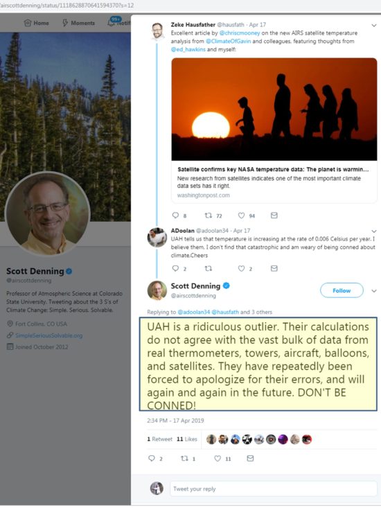
First of all, I have no idea what Scott is talking about when he lists “towers” and “aircraft”…there has been no comprehensive comparisons of such data sources to global satellite data, mainly because there isn’t nearly enough geographic coverage by towers and aircraft.
Secondly, in the 25+ years that John Christy and I have pioneered the methods that others now use, we made only one “error” (found by RSS, and which we promptly fixed, having to do with an early diurnal drift adjustment). The additional finding by RSS of the orbit decay effect was not an “error” on our part any more than our finding of the “instrument body temperature effect” was an error on their part. All satellite datasets now include adjustments for both of these effects.
Nevertheless, as many of you know, our UAH dataset is now considered the “outlier” among the satellite datasets (which also include RSS, NOAA, and U. of Washington), with the least amount of global-average warming since 1979 (although we agree better in the tropics, where little warming has occurred). So let’s address the remaining claim of Scott Denning’s: that we disagree with independent data.
The only direct comparisons to satellite-based deep-layer temperatures are from radiosondes and global reanalysis datasets (which include all meteorological observations in a physically consistent fashion). What we will find is that RSS, NOAA, and UW have remaining errors in their datasets which they refuse to make adjustments for.
From late 1998 through 2004, there were two satellites operating: NOAA-14 with the last of the old MSU series of instruments on it, and NOAA-15 with the first new AMSU instrument on it. In the latter half of this overlap period there was considerable disagreement that developed between the two satellites. Since the older MSU was known to have a substantial measurement dependence on the physical temperature of the instrument (a problem fixed on the AMSU), and the NOAA-14 satellite carrying that MSU had drifted much farther in local observation time than any of the previous satellites, we chose to cut off the NOAA-14 processing when it started disagreeing substantially with AMSU. (Engineer James Shiue at NASA/Goddard once described the new AMSU as the “Cadillac” of well-calibrated microwave temperature sounders).
Despite the most obvious explanation that the NOAA-14 MSU was no longer usable, RSS, NOAA, and UW continue to use all of the NOAA-14 data through its entire lifetime and treat it as just as accurate as NOAA-15 AMSU data. Since NOAA-14 was warming significantly relative to NOAA-15, this puts a stronger warming trend into their satellite datasets, raising the temperature of all subsequent satellites’ measurements after about 2000.
But rather than just asserting the new AMSU should be believed over the old (drifting) MSU, let’s look at some data. Since Scott Denning mentions weather balloon (radiosonde) data, let’s look at our published comparisons between the 4 satellite datasets and radiosondes (as well as global reanalysis datasets) and see who agrees with independent data the best:
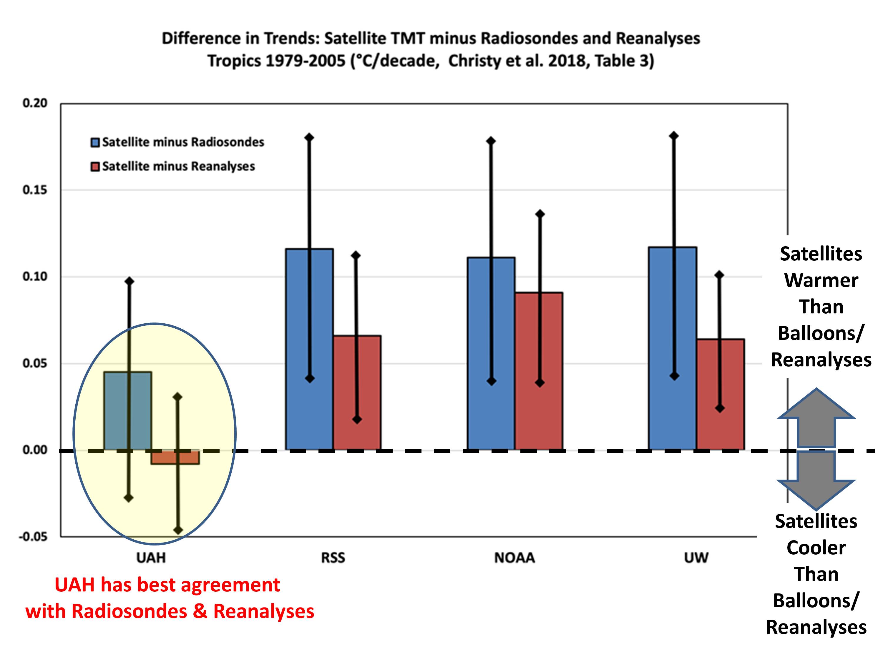
Clearly, the RSS, NOAA, and UW satellite datasets are the outliers when it comes to comparisons to radiosondes and reanalyses, having too much warming compared to independent data.
But you might ask, why do those 3 satellite datasets agree so well with each other? Mainly because UW and NOAA have largely followed the RSS lead… using NOAA-14 data even when its calibration was drifting, and using similar strategies for diurnal drift adjustments. Thus, NOAA and UW are, to a first approximation, slightly altered versions of the RSS dataset.
Maybe Scott Denning was just having a bad day. In the past, he has been reasonable, being the only climate “alarmist” willing to speak at a Heartland climate conference. Or maybe he has since been pressured into toeing the alarmist line, and not being allowed to wander off the reservation.
In any event, I felt compelled to defend our work in response to what I consider (and the evidence shows) to be an unfair and inaccurate attack in social media of our UAH dataset.
UPDATE from John Christy (11:10 CDT April 26, 2019):
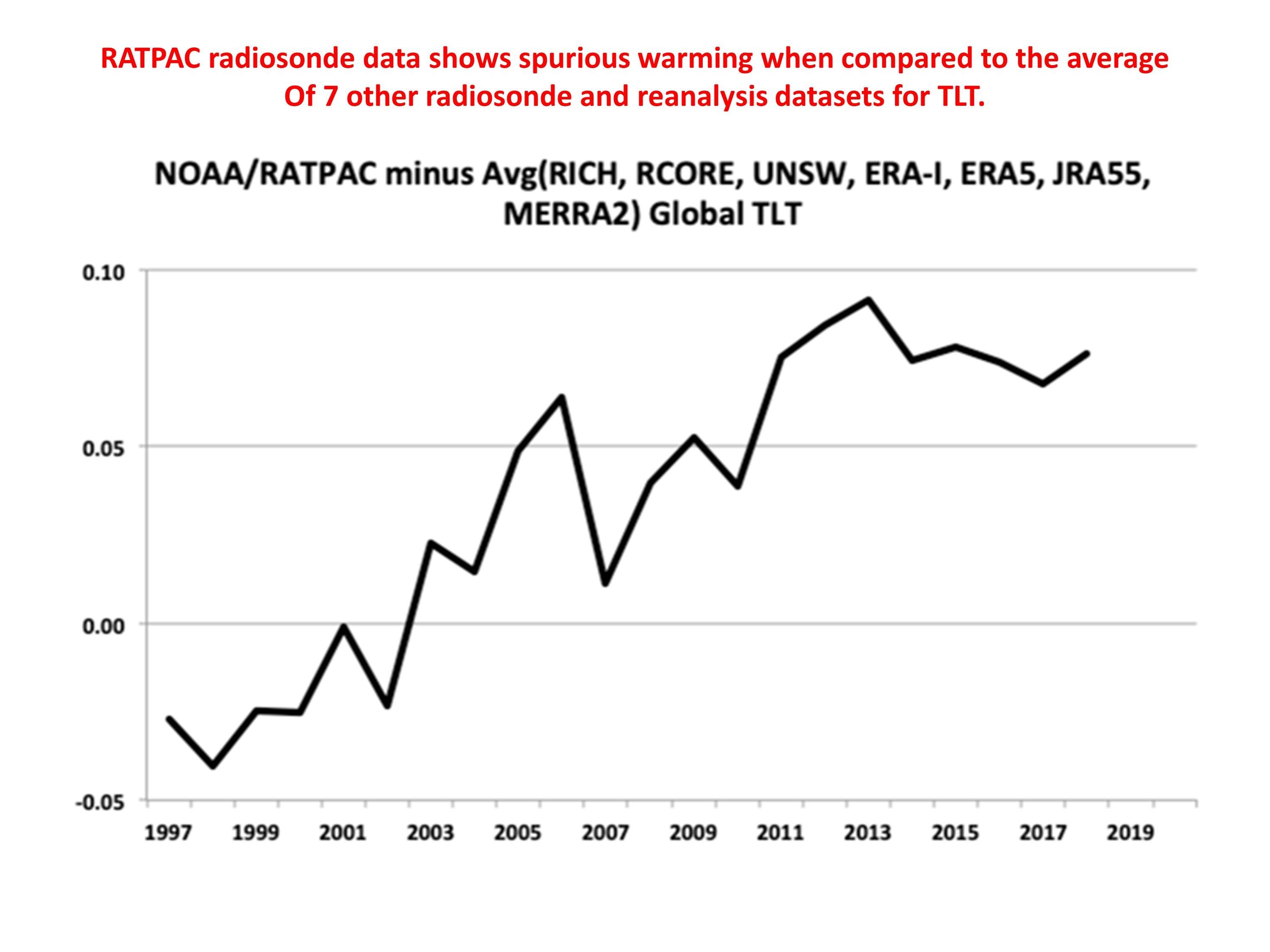
In response to comments about the RATPAC radiosonde data having more warming, John Christy provides the following:
The comparison with RATPAC-A referred to in the comments below is unclear (no area mentioned, no time frame). But be that as it may, if you read our paper, RATPAC-A2 was one of the radiosonde datasets we used. RATPAC-A2 has virtually no adjustments after 1998, so contains warming shifts known to have occurred in the Australian and U.S. VIZ sondes for example. The IGRA dataset used in Christy et al. 2018 utilized 564 stations, whereas RATPAC uses about 85 globally, and far fewer just in the tropics where this comparison shown in the post was made. RATPAC-A warms relative to the other radiosonde/reanalyses datasets since 1998 (which use over 500 sondes), but was included anyway in the comparisons in our paper. The warming bias relative to 7 other radiosonde and reanalysis datasets can be seen in the following plot: