
 Home/Blog
I have previously addressed the NASA study that concluded the AIRS satellite temperatures “verified global warming trends“. The AIRS is an infrared temperature sounding instrument on the NASA Aqua satellite, providing data since late 2002 (over 16 years). All results in that study, and presented here, are based upon infrared measurements alone, with no microwave temperature sounder data being used in these products.
That reported study addressed only the surface “skin” temperature measurements, but the AIRS is also used to retrieve temperature profiles throughout the troposphere and stratosphere — that’s 99.9% of the total mass of the atmosphere.
Since AIRS data are also used to retrieve a 2 meter temperature (the traditional surface air temperature measurement height), I was curious why that wasn’t used instead of the surface skin temperature. Also, AIRS allows me to compare to our UAH tropospheric deep-layer temperature products.
So, I downloaded the entire archive of monthly average AIRS temperature retrievals on a 1 deg. lat/lon grid (85 GB of data). I’ve been analyzing those data over various regions (global, tropical, land, ocean). While there are a lot of interesting results I could show, today I’m going to focus just on the United States.
Because the Aqua satellite observes at nominal local times of 1:30 a.m. and 1:30 p.m., this allows separation of data into “day” and “night”. It is well known that recent warming of surface air temperatures (both in the U.S. and globally) has been stronger at night than during the day, but the AIRS data shows just how dramatic the day-night difference is… keeping in mind this is only the most recent 16.6 years (since September 2002):
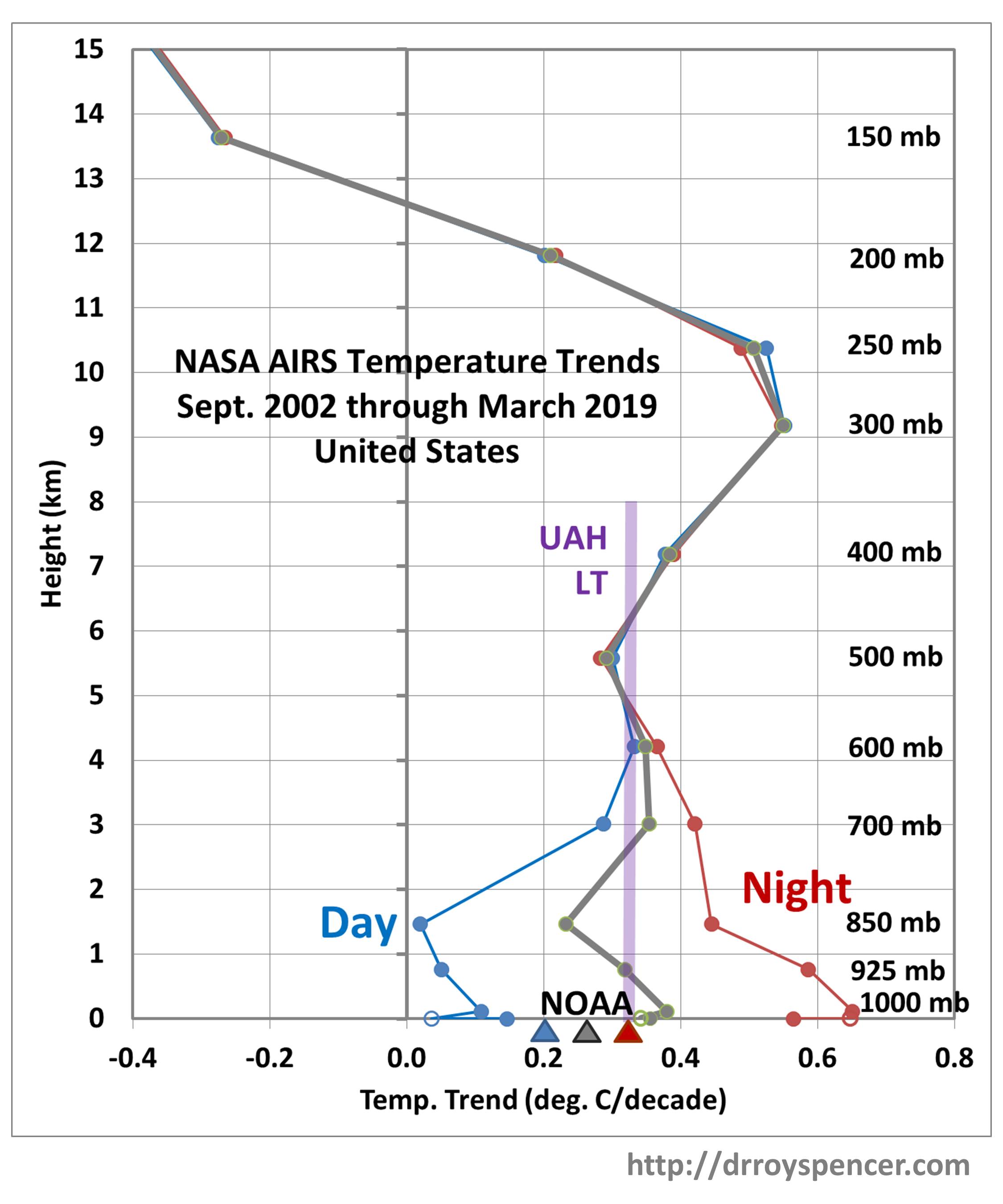
The AIRS surface skin temperature trend at night (1:30 a.m.) is a whopping +0.57 C/decade, while the daytime (1:30 p.m.) trend is only +0.15 C/decade. This is a bigger diurnal difference than indicated by the NOAA Tmax and Tmin trends (triangles in the above plot). Admittedly, 1:30 a.m. and 1:30 pm are not when the lowest and highest temperatures of the day occur, but I wouldn’t expect as large a difference in trends as is seen here, at least at night.
Furthermore, these day-night differences extend up through the lower troposphere, to higher than 850 mb (about 5,000 ft altitude), even showing up at 700 mb (about 12,000 ft. altitude).
This behavior also shows up in globally-averaged land areas, and reverses over the ocean (but with a much weaker day-night difference). I will report on this at some point in the future.
If real, these large day-night differences in temperature trends is fascinating behavior. My first suspicion is that it has something to do with a change in moist convection and cloud activity during warming. For instance more clouds would reduce daytime warming but increase nighttime warming. But I looked at the seasonal variations in these signatures and (unexpectedly) the day-night difference is greatest in winter (DJF) when there is the least convective activity and weakest in summer (JJA) when there is the most convective activity.
One possibility is that there is a problem with the AIRS temperature retrievals (now at Version 6). But it seems unlikely that this problem would extend through such a large depth of the lower troposphere. I can’t think of any reason why there would be such a large bias between day and night retrievals when it can be seen in the above figure that there is essentially no difference from the 500 mb level upward.
It should be kept in mind that the lower tropospheric and surface temperatures can only be measured by AIRS in the absence of clouds (or in between clouds). I have no idea how much of an effect this sampling bias would have on the results.
Finally, note how well the AIRS low- to mid-troposphere temperature trends match the bulk trend in our UAH LT product. I will be examining this further for larger areas as well.


Good post. I learn something new and challenging on sites
I stumbleupon everyday. It’s always useful to read through articles from other
authors and use something from other web sites.
It is in reality a great and helpful piece of info.
I am glad that you simply shared this useful information with us.
Please keep us up to date like this. Thank you for sharing.