Archive for September, 2014

Tonight’s Aurora Could Reach Southern States

Thursday, September 11th, 2014

Aurora on 28 Aug. 2014 as seen over Lake Superior, from Marquette, MI (courtesy Lake Superior Photography).

Aurora on 28 Aug. 2014 as seen over Lake Superior, from Marquette, MI (courtesy Lake Superior Photography).


The first of a pair of solar coronal mass ejections (CMEs) from sunspot AR2158 is supposed to reach Earth tonight, providing auroral displays (northern lights) unusually far south.

According to the most recent advisory from NOAA’s Space Weather Prediction Center,

“…conditions such as these could lead to auroras observed from the middle or southern states.”

Of course, any auroral displays visible in the southern U.S. are exceedingly rare. The last event that far south was October 24, 2011, with aurora visible as far south as Oklahoma and Alabama.

The second of the CMEs is traveling faster than the first, and is supposed to reach Earth about a day later. The probability of more events remains relatively high. According to SpaceWeather.com,

“More radio bursts may be in the offing. Sunspots AR2157 and AR2158 have unstable magnetic fields that harbor energy for strong explosions. NOAA forecasters estimate a 40% chance of X-class flares and a whopping 85% chance of M-flares on Sept. 11th.”

Here’s the latest solar wind model forecast for midnight tonight, showing the passage of the first plasma event from the first CME, and then second one following it:

Solar wind plasma density forecast for midnight tonight, showing two solar eruption events arriving at Earth.

Solar wind plasma density forecast for midnight tonight, showing two solar eruption events arriving at Earth.

The model animation is pretty cool, and provides a good conceptual view of how these plasma events exit the Sun and travel toward the Earth.

For those interested in viewing tonight, try NOAA’s Ovation aurora monitoring tool, which is based upon the latest polar orbiting satellite measurements. If that page is not up to date with the latest satellite data, this one usually is.

Water Vapor Feedback and the Global Warming Pause

Wednesday, September 10th, 2014

evaporation-precipitation1
Global warming is the predicted result of increasing atmospheric CO2 causing a very small (~1-2%) decrease in the rate at which the Earth cools to outer space though infrared radiation. And the since temperature change of anything is always the result of net gains and losses of energy, a decrease in energy lost leads to warming.

The direct effect of that warming is only about 1 deg. C in the next 100 years, though (theoretically calculated, in response to an eventual doubling of CO2 late in this century). Climate models instead project 2 to 3 times as much warming as that, due to “positive feedbacks” in the climate system.

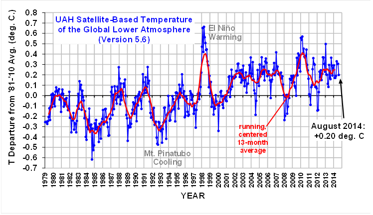
But the Earth hasn’t warmed as much as expected by the global warming pundits and their positive feedbacks, especially in the tropics where deep moist convection dominates the atmosphere’s response to forcing.

Why?

We know that water vapor is the main atmospheric gas which reduces the Earth’s ability to radiatively cool in the infrared (IR). And, unlike CO2, water vapor varies tremendously due to a variety of processes.

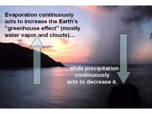
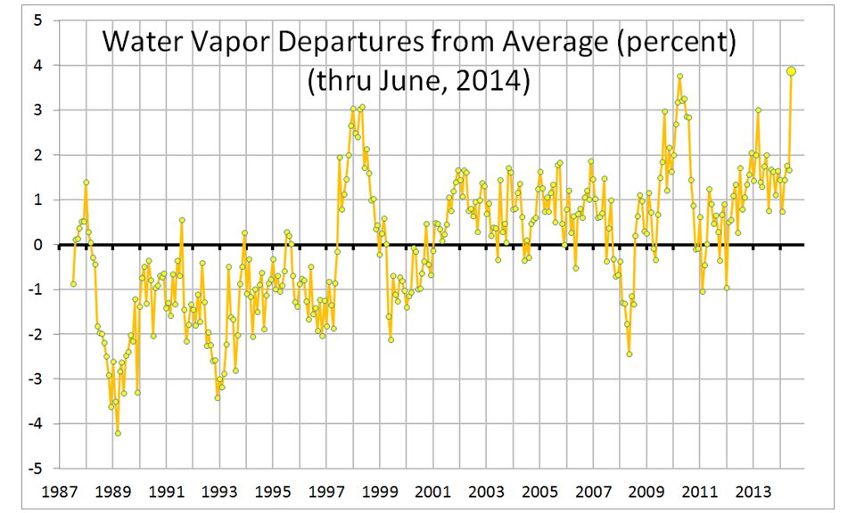
Increasing surface temperatures cause more evaporation which by itself increases the water vapor content of the atmosphere. Water vapor at low altitudes has indeed increased with warming, as I have shown here (over the oceans):
Fig. 2. As in Fig. 1, but for SSM/I integrated water vapor.

So, the simple-minded assumption has been that warming caused by increasing CO2 would cause more water vapor, which will enhance the radiative warming. That’s called positive water vapor feedback, which roughly doubles the amount of warming from the CO2 increase alone in climate models.

[Yes, I know that more water vapor evaporated from the surface cools the surface…that’s taken into account by the climate models, too.]

But for many years I have advocated the view that water vapor feedback on the long time scales of climate change might not be positive. Clearly, something is causing the current “pause” in global warming. The three most likely causes of the pause (in my view, not prioritized) are: (1) increasing cloud reflection reducing the solar input, or (2) decreasing water vapor (and maybe cirrus clouds) in the upper troposphere increasing the infrared output, or (3) an increase in ocean mixing sequestering extra heat in the deep ocean. Or, some combination of the three. (I’m not a big fan of other theories, like more aerosol reflection of sunlight from dirty Chinese coal, or problems with the CO2 theory itself. Not that they are necessarily wrong.)

Our 1997 BAMS paper (Spencer & Braswell, 1997) discussed the importance of middle and upper tropospheric vapor to the IR cooling rate of the Earth. I also blogged about water vapor feedback four years ago. Basically, the bottom line is that it’s the processes controlling upper tropospheric water vapor which have the biggest impact on the IR cooling rate of the Earth.
atmos-hydro-cycle-small

As Spencer & Braswell (1997) showed, at low relative humidities often seen in the upper troposphere (below, say, 30%) a tiny change in water vapor content has a huge effect of the infrared cooling rate of the Earth. So you can have large increases in lower tropospheric vapor, but a small decrease in upper tropospheric vapor can completely negate the resulting water vapor feedback.

A recent paper which claims to have new satellite evidence of positive water vapor feedback uses highly uncertain infrared water vapor channel data (6.7 microns) which has unknown long-term instrument stability, and unknown diurnal drift effects (issues which we have spent 20 years on with the microwave temperature sounders), and unknown cloud contamination effects.

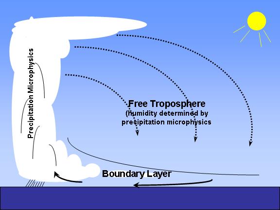
The important thing to understand is this: the largest control of water vapor feedback is the efficiency of precipitation systems, which controls how much water vapor is detrained into the upper troposphere. This process is what controls the humidity of the atmosphere on a clear day…that clear air is being forced to sink by rising air in precipitation systems, and its humidity (and thus its influence on the IR cooling rate of the clear air to space) can also be traced back to microphysical processes in precipitation systems. Clear air might seem boring, but it has a huge influence on the Earth’s temperature, through its humidity controlling the rate at which the Earth cools to space.

While climate models can be tuned to produce the average amount of water vapor in the upper troposphere reasonably realistically, we do not understand how precipitation efficiency changes with warming, and so the physics cannot currently be included in climate models for the purpose of predicting climate change.

On the subject of this uncertainty, a 20-year old paper by Renno, Emanuel, and Stone (1994) concluded:

The cumulus convection schemes currently in use in GCMs (general circulation models) bypass the microphysical processes by making arbitrary moistening assumptions. We suggest that they are inadequate for climate change studies.

That paper described from a theoretical point of view how high precipitation efficiency causes a cool and dry climate, while low precipitation efficiency causes a warm and moist climate.

While I’m sure that convective parameterizations are better today than they were 20 years ago, they really can’t address something this complex. Even much more sophisticated cloud resolving models (CRMs) still make rather arbitrary assumptions regarding the conversion of cloud to precipitation. And that which isn’t converted to precipitation re-evaporates and then changes the humidity of clear air.

It might well be that the limited radiosonde evidence we have of lower tropospheric moistening and upper tropospheric drying (e.g. Paltridge et al., 2009) is telling us that water vapor feedback is not positive, as is currently assumed in climate models. This is basically the reason why Miskolczi (2010) found a constant greenhouse effect…that the observed decrease in upper tropospheric humidity (which is controversial from an observational standpoint) just offset the warming caused by increasing CO2.

None of the above regarding water vapor feedback is new, and even our 1997 paper examined issues Dick Lindzen was advocating at least a decade before us. I’m presenting it again to remind ourselves of how little we really know about climate change.

And don’t even get me started on cloud feedback.

Sept. 21, NYC: The People’s Frozen Climate March?

Tuesday, September 9th, 2014

It seems more than appropriate that the Gore Effect might be in full swing in NYC on Sept. 21 when climate hand-wringers from around the country gather to protest the world being maybe a full degree warmer than it was 100 years ago.

The latest Climate Forecast System forecast for the 10-day period around that blessed event (12 days from now) shows the eastern U.S. pretty dang chilly, with temperatures averaging 8-10 deg. below normal (Plot courtesy of WeatherBell.com):

cfs_anom_t2m_conus_2014090906_x61

Of course, now that cold weather is also the fault of global warming the participants can complain about that, too.

September Snow in Seven States over Seven Days

Saturday, September 6th, 2014

Sunday update: make that eight states.

Looks like September snows — not even mountain snows — over the northern tier of states spreading eastward from Montana and North Dakota starting Tuesday night.

The latest GFS model total snow accumulation by next Saturday shows snow for Montana, Wyoming (mountains only), the Dakotas, Nebraska, Minnesota, Wisconsin, and Michigan (plot courtesy of WeatherBell.com):
gfs_6hr_snow_acc_conus2_49

I suspect any “lake effect” in Michigan will be ice pellets embedded in rain showers coming off the lakes, which are probably still too warm for snow. Michigan lake effect snow usually holds off till October, at the earliest.

Regarding how unusual this is, here’s a plot of the average times of first snow…as you can see, the predicted snow is about a month early:
wxwhyAverageTimeOfFirstSnow385X287X96

Explosive Eruption of Mount Tavurvur, Up Close and Personal

Saturday, September 6th, 2014

This is amazing video (with sound) of the recent explosive eruption of Mount Tavurvur in Papua New Guinea, taken by Phil McNamara. Few people in the world will ever get to witness something like this, let alone capture video of it. Note the shockwave that travels along the ground as well as through the cloud layer. I have no idea how large the boulders are that were ejected, but I suppose one could roughly estimate how high they reached by timing how long it took them to fall.

At the Crossroads: Energy and Climate Policy Summit

Friday, September 5th, 2014

energy-summit-regonline-H.jpg I will be appearing at a 2-day conference called At the Crossroads: Energy and Climate Policy Summit, at the Hyatt Regency in Houston, TX, Sept. 25-26, 2014.

Speakers on the star-studded agenda currently include (in the order they appear):

Matt Ridley (“The Rational Optimist”)
Roy Spencer (UAH)
Judith Curry (GaTech)
Hal Doiron (The Right Climate Stuff)
Zong-Liang Yang (U. Texas – Austin)
Eric Groten (Vinson & Elkins)
Marlo Lewis (CEI)
Mike Nasi (Jackson Walker)
Rupert Darwall (“The Age of Global Warming”)
Stephen Moore (Heritage)
Marc Morano (Climate Depot)
Mark Mills (Manhattan Inst.)
Rob Bradley (Inst. for Energy Research)
Peter Grossman (Butler U.)
David Kreutzer (Heritage)
Calvin Beisner (Cornwall Alliance)
Kathleen Hartnett White (Armstrong Center for Energy and the Environment)
Caleb Rossiter (American University)
H. Leighton Steward (Plants Need CO2)
Frank Clemente (Penn State)

Standard registration is $75, while students, media, and government representatives are free.

UAH Global Temperature Update for August 2014: +0.20 deg. C

Tuesday, September 2nd, 2014

The Version 5.6 global average lower tropospheric temperature (LT) anomaly for August, 2014 is +0.20 deg. C, down from July’s value of +0.31 deg. C (click for full size version):
UAH_LT_1979_thru_August_2014_v5

The global, hemispheric, and tropical LT anomalies from the 30-year (1981-2010) average for the last 20 months are:

YR MON GLOBAL NH SH TROPICS
2013 1 +0.497 +0.517 +0.478 +0.386
2013 2 +0.203 +0.372 +0.033 +0.195
2013 3 +0.200 +0.333 +0.067 +0.243
2013 4 +0.114 +0.128 +0.101 +0.165
2013 5 +0.082 +0.180 -0.015 +0.112
2013 6 +0.295 +0.335 +0.255 +0.220
2013 7 +0.173 +0.134 +0.211 +0.074
2013 8 +0.158 +0.111 +0.206 +0.009
2013 9 +0.365 +0.339 +0.390 +0.190
2013 10 +0.290 +0.331 +0.249 +0.031
2013 11 +0.193 +0.160 +0.226 +0.020
2013 12 +0.266 +0.272 +0.260 +0.057
2014 1 +0.291 +0.387 +0.194 -0.029
2014 2 +0.170 +0.320 +0.020 -0.103
2014 3 +0.170 +0.338 +0.002 -0.001
2014 4 +0.190 +0.358 +0.022 +0.092
2014 5 +0.326 +0.325 +0.328 +0.175
2014 6 +0.305 +0.315 +0.295 +0.510
2014 7 +0.304 +0.289 +0.319 +0.451
2014 8 +0.199 +0.244 +0.154 +0.060

It should be remembered that during ENSO, there is a 1-2 month lag between SST change and tropospheric temperature changes, so what the SST anomaly is doing lately gives you a rough idea of how the tropospheric temperature anomaly will be changing in a couple of months.

The global image for August should be available in the next day or so here.

Popular monthly data files (these might take a few days to update):

uahncdc_lt_5.6.txt (Lower Troposphere)
uahncdc_mt_5.6.txt (Mid-Troposphere)
uahncdc_ls_5.6.txt (Lower Stratosphere)