Archive for 2016

No, Spencer’s Research Wasn’t Funded by Peabody

Wednesday, June 15th, 2016

My vacation this week was interrupted this morning by some hate e-mail…apparently, the recent Peabody Coal bankruptcy produced paperwork that listed everyone that was ever paid by Peabody for anything.

As far as I can recall, I am quite sure that Peabody has paid me for two things. Neither was payment for climate research, but just for presentation of information and opinions.

First was a presentation I gave to their board of directors, maybe 2-3 years ago, for which I charged my usual speaking fee plus travel expenses to Washington D.C. As I recall, my talk was back-to-back with one by a representative from Natural Resources Defense Council.

The second instance was hearing testimony I was asked to write related to a legal case I’ve already blogged about, here. That took quite a bit of time, requiring rebuttal and surrebuttal testimonies, then travel to St. Paul, MN to testify in front of a judge. I don’t do such things for free, and I always make sure I do it on vacation time from my day job so I can’t be accused of double-dipping.

If people are that concerned about not having any financial relationships with fossil fuel interests, I suggest they stop using electricity and most of our modern conveniences. I would have accepted payment from Satanists for Sane Energy Policy for my opinions if it would help prevent energy poverty and the resulting preventable deaths.

Another Potential Reason Why Climate Sensitivity is Over-Estimated

Thursday, June 2nd, 2016

No, not that kind of feedback...

No, not that kind of feedback…


BACKGROUND

It’s been quite a while since I’ve discussed why the diagnosis of feedbacks in the climate system (and thus climate sensitivity) from observations is biased toward high climate sensitivity. It’s a controversial topic, one which we have a few published papers on, yet one I am more firmly convinced about than any other climate research I have ever published.

I’m pretty convinced that most of our detractors on the subject don’t even know what we are talking about. The refutations against our work have been a mixture of strawman arguments, red herrings, silliness, and deception.

To put it simply, if temperature change causes a change in the top-of-atmosphere radiative balance, then you can (with some assumptions regarding time lags) diagnose feedbacks by simply regressing the radiative variations against the temperature variations. BUT if it is instead a time-varying radiative imbalance causing a surface temperature change (causation reversed), then you cannot diagnose feedbacks.

If you try, then you will usually diagnose positive feedback, even if strongly negative feedback exists. Our most complete analysis of the effect was described here.

In general, both directions of causation are operating in the climate system. People like Andy Dessler will claim that ALL radiation changes are ultimately caused by temperature change, maybe at some earlier time, and so he thinks you can diagnose feedback.

But I totally reject that…there are many reasons why (for example) clouds (and thus albedo) can change that are not caused by temperature.

And if Dr. Dessler really believes it, why does he not include a time lag in his feedback diagnoses? (It usually take time — sometimes months — for the atmospheric response to a surface temperature change to fully develop). When you do that, the diagnosed feedback parameter almost always shifts in the direction of low climate sensitivity (Dick Lindzen has also published work on this issue).

ANOTHER REASON WHY FEEDBACKS CAN BE BIASED POSITIVE

For years, I’ve been mulling another reason (other than the radiation-causing-temperature change one) for diagnosed feedbacks to be biased positive. It would occur if different sources of climate variation have different feedbacks.

When feedbacks are strongly negative, then temperature changes will be minimized, because that’s what negative feedback does — it damps temperature change.

But when feedbacks are positive, the temperature changes are allowed to grow.

So, the BIG temperature changes and their associated radiation changes during positive feedback events will dominate our observations of the climate system, while the small temperature changes during negative feedback events will be less noticeable.

The net result will be an average diagnosed feedback that is biased positive, that is, toward high climate sensitivity, because we are really only analyzing the big climate events that were allowed to grow due to positive feedbacks.

1D FORCING-FEEDBACK MODEL TEST

One can test this idea quantitatively with a simple 1D forcing-feedback energy balance model (like the one we have use in our papers, but here assuming a simple 1-layer swamp ocean 25 m deep, and a 30 day time step). If I force the ocean surface temperatures departures from an average state with a random number generator that is smoothed in time, then assume a sinusoidally varying feedback parameter between 0 and 6.4 W m-2 K-1 over a period of 28 months as the radiative response to those temperature variations, I get behavior like this:
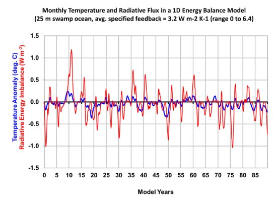
simple-1d-model-with-variable-feedback-timeseries

The net feedback parameter diagnosis is then usually just the regression slope between the radiative flux variations and the temperature variations, which from the model output looks like this:
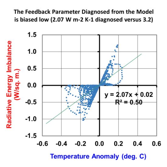
simple-1d-model-with-variable-feedback-scatterplot

We see that the regression diagnosis of the feedback parameter is biased low. Instead of an average of 3.2 W m-2 K-1 as specified (which would be 1.2 deg. C equilibrium climate sensitivity), the diagnosis is 2.07 W m-2 K-1 (about 1.8 deg. C climate sensitivity).

If I add in some time-varying radiative forcing like we have addressed in our recent papers (e.g. this one), the bias toward high climate sensitivity is even greater (not shown here).

The above discussion is nowhere near exhaustive; I’m just trying to stimulate thought and discussion on an issue I feel very strongly about, that is: climate feedbacks diagnosed from observational data are very error-prone, with the errors most likely leading to overestimates of climate sensitivity.

UAH Global Temperature Update for May, 2016: +0.55 deg. C

Wednesday, June 1st, 2016

NOTE: This is the fourteenth monthly update with our new Version 6.0 dataset. Differences versus the old Version 5.6 dataset are discussed here. Note we are now at “beta5” for Version 6, and the paper describing the methodology is still in peer review.

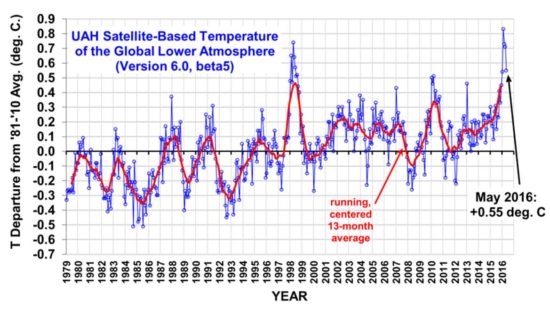
The Version 6.0 global average lower tropospheric temperature (LT) anomaly for May, 2016 is +0.55 deg. C, down 0.16 deg. C from the April value of +0.71 deg. C (click for full size version):

UAH_LT_1979_thru_May_2016_v6

The global, hemispheric, and tropical LT anomalies from the 30-year (1981-2010) average for the last 17 months are:

YEAR MO GLOBE NHEM. SHEM. TROPICS
2015 01 +0.30 +0.44 +0.15 +0.13
2015 02 +0.19 +0.34 +0.04 -0.07
2015 03 +0.18 +0.28 +0.07 +0.04
2015 04 +0.09 +0.19 -0.01 +0.08
2015 05 +0.27 +0.34 +0.20 +0.27
2015 06 +0.31 +0.38 +0.25 +0.46
2015 07 +0.16 +0.29 +0.03 +0.48
2015 08 +0.25 +0.20 +0.30 +0.53
2015 09 +0.23 +0.30 +0.16 +0.55
2015 10 +0.41 +0.63 +0.20 +0.53
2015 11 +0.33 +0.44 +0.22 +0.52
2015 12 +0.45 +0.53 +0.37 +0.61
2016 01 +0.54 +0.69 +0.39 +0.84
2016 02 +0.83 +1.17 +0.50 +0.99
2016 03 +0.73 +0.94 +0.52 +1.09
2016 04 +0.71 +0.85 +0.58 +0.94
2016 05 +0.55 +0.65 +0.44 +0.72

Cooling from the weakening El Nino is now rapidly occurring as we transition toward likely La Nina conditions by mid-summer or early fall.

The “official” UAH global image for May, 2016 should be available in the next several days here.

The new Version 6 files (use the ones labeled “beta5”) should be updated soon, and are located here:

Lower Troposphere: http://vortex.nsstc.uah.edu/data/msu/v6.0beta/tlt/uahncdc_lt_6.0beta5.txt
Mid-Troposphere: http://vortex.nsstc.uah.edu/data/msu/v6.0beta/tmt/uahncdc_mt_6.0beta5.txt
Tropopause: http://vortex.nsstc.uah.edu/data/msu/v6.0beta/ttp/uahncdc_tp_6.0beta5.txt
Lower Stratosphere: http://vortex.nsstc.uah.edu/data/msu/v6.0beta/tls/uahncdc_ls_6.0beta5.txt

UAH V6 Global Temperature Update for April, 2016: +0.71 deg. C

Monday, May 2nd, 2016

NOTE: This is the thirteenth monthly update with our new Version 6.0 dataset. Differences versus the old Version 5.6 dataset are discussed here. Note we are now at “beta5” for Version 6, and the paper describing the methodology is in peer review.

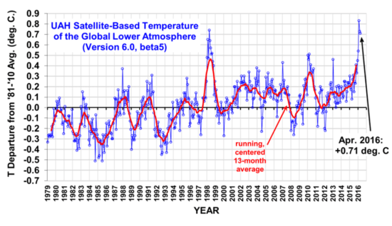
The Version 6.0 global average lower tropospheric temperature (LT) anomaly for April, 2016 is +0.71 deg. C, down slightly from the March value of +0.73 deg. C (click for full size version):

UAH_LT_1979_thru_April_2016_v6

The global, hemispheric, and tropical LT anomalies from the 30-year (1981-2010) average for the last 16 months are:

YEAR MO GLOBE NHEM. SHEM. TROPICS
2015 01 +0.30 +0.44 +0.15 +0.13
2015 02 +0.19 +0.34 +0.04 -0.07
2015 03 +0.18 +0.28 +0.07 +0.04
2015 04 +0.09 +0.19 -0.01 +0.08
2015 05 +0.27 +0.34 +0.20 +0.27
2015 06 +0.31 +0.38 +0.25 +0.46
2015 07 +0.16 +0.29 +0.03 +0.48
2015 08 +0.25 +0.20 +0.30 +0.53
2015 09 +0.23 +0.30 +0.16 +0.55
2015 10 +0.41 +0.63 +0.20 +0.53
2015 11 +0.33 +0.44 +0.22 +0.52
2015 12 +0.45 +0.53 +0.37 +0.61
2016 01 +0.54 +0.69 +0.39 +0.84
2016 02 +0.83 +1.17 +0.50 +0.99
2016 03 +0.73 +0.94 +0.52 +1.09
2016 04 +0.71 +0.85 +0.58 +0.94

I expect average cooling to continue throughout the year as El Nino weakens and is replaced with La Nina, now expected by mid-summer or early fall. Nevertheless, 2016 could still end up as a record warm year in the satellite record…it all depends upon how fast the warmth from the El Nino dissipates and La Nina sets in.

The “official” UAH global image for April, 2016 should be available in the next several days here.

The new Version 6 files (use the ones labeled “beta5”) should be updated soon, and are located here:

Lower Troposphere: http://vortex.nsstc.uah.edu/data/msu/v6.0beta/tlt/uahncdc_lt_6.0beta5.txt
Mid-Troposphere: http://vortex.nsstc.uah.edu/data/msu/v6.0beta/tmt/uahncdc_mt_6.0beta5.txt
Tropopause: http://vortex.nsstc.uah.edu/data/msu/v6.0beta/ttp/uahncdc_tp_6.0beta5.txt
Lower Stratosphere: http://vortex.nsstc.uah.edu/data/msu/v6.0beta/tls/uahncdc_ls_6.0beta5.txt

William Gray, Hurricane Researcher and Skeptic, Dead at 86

Saturday, April 16th, 2016

Myself, Bill Gray, and Marc Morano in Las Vegas, July, 2014.

Myself, Bill Gray, and Marc Morano in Las Vegas, July, 2014.

I just learned through Climate Depot and Tony Heller that Bill Gray has died.

Bill was a pioneering researcher and hurricane forecaster, as well as a skeptic of the seriousness of the manmade global warming threat.

Bill’s legacy goes well back before my time…and I’m getting to be an old guy (60). He was at most of the Heartland conferences, and he always made it a point to spend time with me. In fact, he was embarrassingly effusive with his praise. He was quite a character, and very sharp. We didn’t always agree on the science, but that’s ok.

My earliest memory of Bill was my very first scientific conference, an AMS Hurricanes and Tropical Meteorology Conference in Oklahoma, maybe around 1982. The big thing then was the mesoscale modelers were all giving papers showing that their model would take a pre-existing tropical disturbance, say an African easterly wave, and turn it into a hurricane. This indeed was an achievement.

After sitting through all of these presentations, Bill Gray, who was sitting just in front of me, stood up and asked in his Jimmy Stewart-esque way, “All you modelers keep showing your models producing a hurricane out of a disturbance…but that usually doesn’t happen…where are the model results showing that a hurricane doesn’t develop?”

I will never forget the question…it was a good one.

Goodbye, Bill. You will be missed.

Why Gavin Schmidt’s Temperature Plot Baseline Issue is Irrelevant

Thursday, April 7th, 2016

Ever since we started posting global temperature comparisons between models and observations there has been a recurring objection over the way the data are plotted. I really thought that the issue would go away because it’s so silly. But I’ve seen it crop up again in the last week in a series of messages between Judy Curry and Gavin Schmidt.

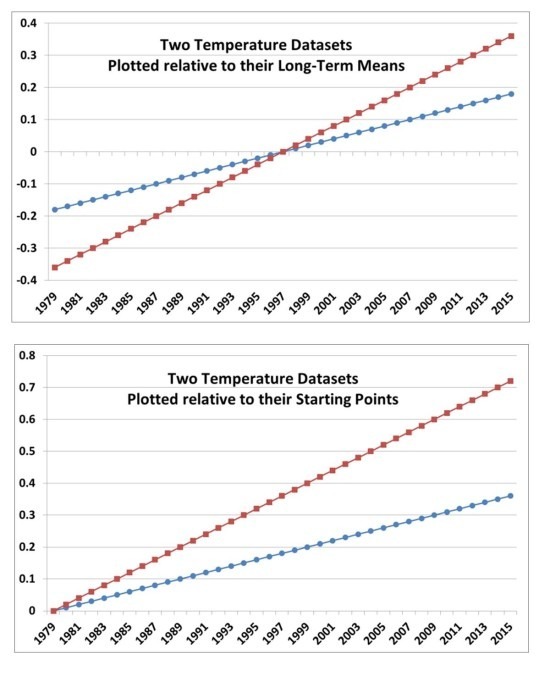
This issue can be summarized with the idealized temperature plots, below. The first plot shows how our critics apparently think two datasets should be plotted for comparison. The second plot is how we think the data should be plotted.

two-temp-datasets-diff-starting-points

Note that no matter which one you choose, though, both plots show what is important… that the red temperature trace is warming twice as fast as the blue trace.

You might say, “but the disagreement in 2015 between the two traces is only half as big in the first plot as it is in the second plot“.

Yes, but that ignores the fact that there the other half of the disagreement has just been shifted to 1979…nothing has been gained.

It’s really the trends which are important (or, if you don’t like linear trends, pick some other metric of long-term temperature change…none of them is perfect).

We choose to plot the data relative to the same point early in the record. We usually do it relative to the average of the first 5 years of data, so that noise in both datasets has a minimum effect on aligning their starting points.

Or, to avoid that problem entirely, you can compute the trends from each dataset and simply plot all of the linear trend lines with the same starting point.

This is because you start a race at the beginning….not in the middle. How much warming we have seen over a certain period of time (say, since 1979) is relative to the start of that time period…not the middle of the period.

That this issue continues to be a point of contention, quite frankly, astonishes me. All I can think of is that the defenders of the climate models cannot allow any significant criticisms of the models to survive, even when the model shortcomings are staring everyone in the face.

UPDATE: It Did Not Snow in Guadeloupe

Monday, April 4th, 2016

"Residents film the falling flakes on Thursday."

“Residents film the falling flakes on Thursday.”


On April Fools day (April 1), there was a report of snow on the tropical island of Guadeloupe on the night of March 31, 2016. Guadeloupe is an island in the northern Lesser Antilles. The news report even mentions a light dusting on the ground.

I’m calling BS on this report.

It claimed to not be an April Fool’s joke.

Well, the movie Fargo was also supposed to be a “true story”.

If people there really saw something, it wasn’t “snow”.

The high temperature at Le Raizet Airport was 83 deg F, and the low was 72, on March 31.

The elevation of the town (St. Claude) where the snow was reported was, at most, 3000 ft. That elevation could have been 10 deg. F colder….maybe 15 deg. F under unusual circumstances. So, we’re talking maybe the upper 50s deg. F at the absolute coldest. Not cold enough for snow, unless under exceptionally low humidity (which would never occur at this location).

There wasn’t a deep, cold air layer sufficient to cause such an event. It would have to have been an amazingly cold air mass, which penetrated deeply into the tropics. To a latitude of 16 deg. N.

So, I’m calling BS on the Guadeloupe snow report.

Crops at Risk: Will This Week Equal the $2 Billion Freeze of 2007?

Monday, April 4th, 2016

Exactly 9 years ago this week, the eastern U.S. was plunged into below-freezing weather after an unusually warm March just got things growing. The result was about $2 billion in agricultural losses across 16 states.

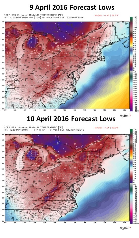
Similar to that Easter 2007 event, the current forecast for late this week has temperatures into the lower 20s as far south as South Carolina; both Saturday and Sunday morning should see below-freezing temperatures into Alabama and Georgia (forecast graphics courtesy of Weatherbell.com):

Morning low temperatures forecast from the GFS model for Saturday and Sunday (9-10 April 2016). Graphics courtesy of Weatherbell.com.

Morning low temperatures forecast from the GFS model for Saturday and Sunday (9-10 April 2016). Graphics courtesy of Weatherbell.com.

The state with the greatest losses in 2007 was Georgia, with about $400 million in damage to blueberries, peaches, pecans, and livestock grasses.

UAH V6 Global Temperature Update for March, 2016: +0.73 deg. C

Friday, April 1st, 2016

NOTE: This is the twelfth monthly update with our new Version 6.0 dataset. Differences versus the old Version 5.6 dataset are discussed here. Note we are now at “beta5” for Version 6, and the paper describing the methodology is in peer review.

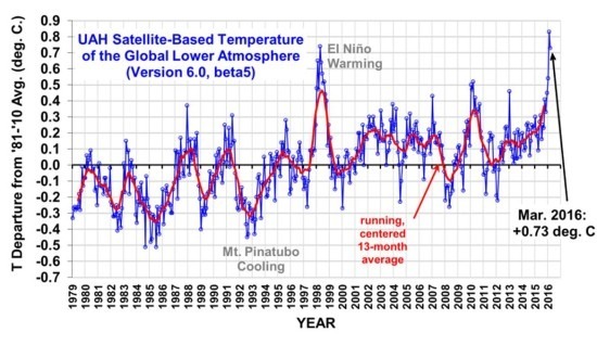
The Version 6.0 global average lower tropospheric temperature (LT) anomaly for March, 2016 is +0.73 deg. C, down a little from the February record-setting value of +0.83 deg. C (click for full size version). This makes March 2016 the warmest March in the satellite record (since 1979), and statistically tied with April 1998 for the second warmest month.

UAH_LT_1979_thru_March_2016_v6

The global, hemispheric, and tropical LT anomalies from the 30-year (1981-2010) average for the last 15 months are:

YEAR MO GLOBE NHEM. SHEM. TROPICS
2015 01 +0.30 +0.44 +0.15 +0.13
2015 02 +0.19 +0.34 +0.04 -0.07
2015 03 +0.18 +0.28 +0.07 +0.04
2015 04 +0.09 +0.19 -0.01 +0.08
2015 05 +0.27 +0.34 +0.20 +0.27
2015 06 +0.31 +0.38 +0.25 +0.46
2015 07 +0.16 +0.29 +0.03 +0.48
2015 08 +0.25 +0.20 +0.30 +0.53
2015 09 +0.23 +0.30 +0.16 +0.55
2015 10 +0.41 +0.63 +0.20 +0.53
2015 11 +0.33 +0.44 +0.22 +0.52
2015 12 +0.45 +0.53 +0.37 +0.61
2016 01 +0.54 +0.69 +0.39 +0.84
2016 02 +0.83 +1.17 +0.50 +0.99
2016 03 +0.73 +0.94 +0.52 +1.09

I suspect that February and March represent peak El Nino warmth in the lower troposphere, and the rest of the year will see cooling. Whether 2016 ends up being a record warm year will depend upon just how fast global temperatures fall as La Nina approaches, now forecast for late summer or early fall.

The “official” UAH global image for March, 2016 should be available in the next several days here.

The new Version 6 files (use the ones labeled “beta5”) should be updated soon, and are located here:

Lower Troposphere: http://vortex.nsstc.uah.edu/data/msu/v6.0beta/tlt/uahncdc_lt_6.0beta5.txt
Mid-Troposphere: http://vortex.nsstc.uah.edu/data/msu/v6.0beta/tmt/uahncdc_mt_6.0beta5.txt
Tropopause: http://vortex.nsstc.uah.edu/data/msu/v6.0beta/ttp/uahncdc_tp_6.0beta5.txt
Lower Stratosphere: http://vortex.nsstc.uah.edu/data/msu/v6.0beta/tls/uahncdc_ls_6.0beta5.txt

Impact of CFSv2 Model Fix on 2016 La Nina Forecast

Thursday, March 31st, 2016

As discussed over at WUWT, there has been a significant change in NOAA’s Climate Forecast System (CFSv2) model resulting from a cold bias that has been developing in the model in the tropical Atlantic ocean temperatures.

Since the NOAA presentation regarding the CFSv2 model problem made it sound like they haven’t been routinely adding ocean observations to the model, I asked NOAA’s David Behringer for clarification, and he said:

First, to be clear, the ocean component of the CFSv2 is routinely updated with the thousands of ocean observations provided daily by many platforms (Argo drifters, TAO-TRITON and other tropical moorings, satellites, etc.) via a variational assimilation method.

At the root of the problem is what is sometimes referred to as the representation error: the mismatch between what the numerical ocean model can resolve versus what the set of ocean observations provide, which are very accurate point measurements of the real ocean. In effect, your reasoning was on the right track, but I would turn it around: it is the inherent limitations of the ocean model, not the accuracy of the observations, that ultimately caused this particular failure.

Let me say a little more about this specific case. The ocean model used in the CFSv2 is built on a variable grid; the resolution over most of the globe is1/2 degree, but within 10 degrees of the equator it is 1/4 degree. A 1/4-dgree grid is considered to be “eddy permitting”, but not “eddy resolving”, meaning that the model dynamics will generate eddies, but these eddies cannot be made to match up with real world eddies. In the 1/2-degree part of the grid we do a reasonably good job managing the representation error through the specification of model and observational error variances, but in the 1/4-degree equatorial zone the job is much harder. In the equatorial zone of the western Atlantic, which is very energetic, the job is harder yet.

The answer is a better assimilation system. The ocean 3D variational (3dvar) system used in the CFSv2 provides a global solution. So we can have a situation where the 3dvar believes the analysis has converged globally, but locally where model-observation differences are too large, for reasons described above, it may not have converged. I think this is what has happened in the CFSv2. We have made improvements to the 3dvar and it is working successfully offline. However, it will need further testing offline before it can be made operational. A temporary emergency fix will be used in the meantime.

Now, I’m not a 3D modeler, but I think what he’s saying is that the numerics in the model in the tropical Atlantic generate unrealistic small-scale ocean eddies in this particularly energetic region that are too intense for the global real-data assimilation system to remove, and they have a temporary model fix in place. (For those not familiar, weather forecast models are typically initialized with a mixture of observations and a previous model forecast, called “3DVAR” methodology, since there is not enough observational data alone to describe the 3D state of the ocean-atmosphere system at any given time.)

Since I was still a little confused about whether the Atlantic cold spot would just reemerge in a many-month model forecast, I asked Dave for clarification on this. He responded:

In this particular case the Atlantic cold spot was caused by a flaw in the data assimilation. Once that was corrected and the cold spot removed, it should not return during the forecast cycle.

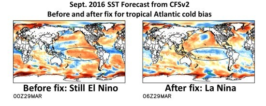
Ryan Maue at Weatherbell.com (which is well worth the $20/month subscription fee to get their full range of model output) provided me some imagery of how the La Nina forecast for later this year suddenly appeared in the CFSv2 model after the cold Atlantic fix was implemented:

Sept. 2016 SST forecast from the CFSv2 model before and after a fix was made for anomalously cold water in the tropical Atlantic (courtesy Ryan Maue, Weatherbell.com).

Sept. 2016 SST forecast from the CFSv2 model before and after a fix was made for anomalously cold water in the tropical Atlantic (courtesy Ryan Maue, Weatherbell.com).

This fix now puts the CFSv2 model forecast of La Nina more in line with the general cluster of ENSO forecasts, which suggest La Nina conditions by late summer or early fall.