Home/Blog
 Congressman Ra�l Grijalva (D-AZ) has sent letters to universities requesting information on the sources of financial support of seven climate researchers. A few of these might well have some portion of their funding come from energy companies, I don�t know.
The implication, of course, is that research money from fossil fuel companies to any skeptics is bad, even though much greater amounts of fossil fuel money goes to Green organizations.
Can you spell �hypocrisy�?
One of the biggest misconceptions about climate research funding is that government funding is unbiased. That is, the belief that government funding does not favor one outcome over another.
This might be true for benign research projects, like the mating habits of the Arctic sea slug, but when it comes to research topics with massive political and economic implications, nothing could be further from the truth.
Government funding programs are, in part, formulated by government political appointees who prefer research with outcomes that support their government programs.
Similarly, university research scientists who provide peer review of proposals for funding favor those proposals which offer to make findings that everyone knows will help to perpetuate funding. After all, it is difficult to get Congress to agree to fund non-problems, and yet climate research funding has to continue in order for the current marching army of lifelong climate researchers to have jobs.
Furthermore, in my experience both government employees and university researchers tend to have a distorted view of where research money comes from, and how prosperity (which is necessary for us to afford scientific research) is achieved. Government managers call their research budgets �funny money�, as if its value did not derive from actual work performed by actual taxpayers.
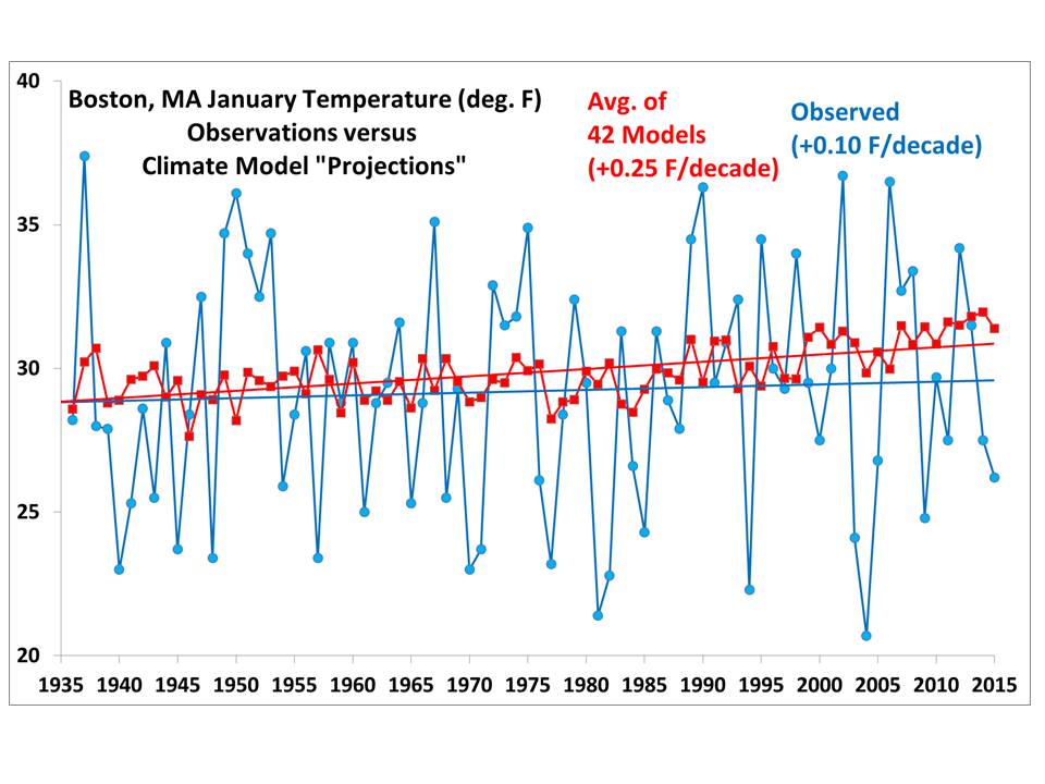
For many years now, government funding of climate research has been infamously resistant toward any theories that climate change isn�t primarily human-driven. I am not aware of any NSF, NOAA, NASA, DOE (or any other funding agency) request for proposals (RFPs) that offered funding to investigate alternative theories of climate change.
This is an unfortunate situation that continues to astonish me, given the immense human cost of proposed energy policies.
I also believe this situation is not what a majority of taxpayers (who foot the bill) would want. The disparity in government funding is not easy to remedy. We have told Congress for years that a Red Team approach to climate research funding is needed, but government funding agencies (which fall under the Executive Branch) would just put the foxes in charge of the hen houses when it came time to form the Red Teams.
The fact that the agencies which fund climate research are technically part of the Executive Branch of government means that the White House has considerable control over outcomes. The recent WH release of what amounts to a directive to go after �climate change deniers� (who the hell denies that climate changes?? Sheesh!) seems to have been the start of an orchestrated effort to shut us down.
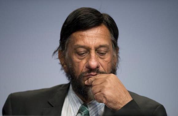
That Roger Pielke, Jr. is one of the current �Skeptical Seven� targets is especially troubling. Roger is quite green and hardly considers himself a skeptic. In fact, he largely agrees with the IPCC. All he asks is that people stop making demonstrably incorrect claims that �climate change� is causing greater damage today than it ever has. (Total monetary losses due to weather rise as prosperity and infrastructure increases, even if weather becomes somewhat less severe). Yet, Roger is now backing out of climate change related research due to the current witch hunt.
I�ll leave it to others to decide whether McCarthyism is a good description of the current situation.
Due to a lack of funding for alternative theories of climate change, a handful of skeptical researchers have turned to private funding from time to time to help keep their research going. Now, I personally don�t care where people get their funding. Their published research must stand on its own merits. And if government refuses to fund both sides, what choice is there other than find a new line of work?
So, will Congressman Grijalva also make similar requests of warmist researchers whose universities took money from energy companies? Does he really think everyone will be blind to the naked hypocrisy of such a move?
What is ironic is that it is the fossil fuel companies which have given money to both sides of the global warming debate. Their giving to Big Green groups has far exceeded their giving to any skeptics. In contrast, government has been the most biased source of funding, refusing to fund virtually all research that might in any way cast doubt on humans being the cause of �climate change�, since it would jeopardize energy policy changes which some politicians and environmentalists have been lusting after for decades.
I suspect my current views on climate change happen to be consistent with what most of the CEOs of coal and petroleum companies would like to hear. But even if they all decided tomorrow that the IPCC is correct after all, and they even offered to pay me to go along with them, I would not change my mind. In my opinion, the bulk of evidence suggests more CO2 in the atmosphere will be good for life on Earth, and in any event there is nothing substantial we can do yet to prevent steadily increasing CO2 without causing immense human suffering.
If we could, then fine, do it as an insurance policy. But no one in their right mind buys insurance that costs more than the payout.
In fact, if government pressure on energy companies continues, I fully expect most CEOs will decide to go along with the government�s desires. They know they are going to get paid anyway, because humanity for the foreseeable future will continue to run on ~85% fossil fuels. They probably will expect to get additional government subsidies to �reduce their carbon footprint�, or some such nonsense.
Follow the money, folks.
So, while we wait to see just how the current witch hunt plays out (which I am told has now been extended to some skeptical-leaning think tanks), let me ask:
1) Are you OK with the fact that U.S. energy policy has been informed by an international scientific organization (the IPCC) whose outgoing chairman this week admitted that global warming is his “religion“? Or that others in the IPCC have admitted their goal is global income redistribution? Is this the �unbiased� source of scientific information you want your government to rely on for energy policy?
2) Are you OK with the fact that U.S. government funding for research into natural sources of climate change has been almost non-existent?
The governmental Goliath is coming after David. It will be interesting to see what happens.